Large prospects have been mapped in ultra-deepwater depths of 3,000m off the Comoros Islands. Photo: ID 45880835 © Presse750/ Dreamstime.com.
Comoros Islands: Multi-billion barrel deepwater hydrocarbon potential
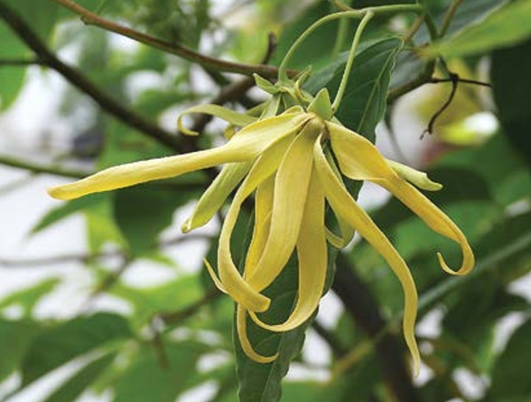
The scent of a new fragrance is in the air in the Perfume Islands. Hopes are high for an exciting new frontier, with multi-billion barrel oil prospects in the same plays that have found giant gas fields in Mozambique
In the 18th century, the Comoros were known as the ‘Perfume Islands’ due to their fragrant flowers, like the yellow ylang-ylang, used in perfumes. Originally imported and cultivated by French colonialists, the ylang-ylang flower provided perfume makers with an exotic source of essential oils, while the 1,862 km2 island archipelago provided France with a strategic base, port and harbour location midway between Arabia, the Indies and East Africa. Independence came late to the volcanic archipelago, in 1975, and since then the island colonies of Grande Comore (Ngazidja), Mohéli (Mwali), and Anjouan (Nzwani) which make up the young Comoros nation have grown to a population of 800,000, with a GDP around $650m and an annual per capita GDP of $850.
Neighbouring Hydrocarbon Discoveries in Mozambique and Tanzania Spark Interest
So when Comoros witnessed billions of dollars in major new investments being made over the past decade in the Mozambique Channel only 300 km away, which led to world-class gas discoveries totalling 200 Tcfg reserves in Mozambique and Tanzania, interest in the Comoros began to stir. This is, after all, more gas than has been found in total in the US offshore Gulf of Mexico or Nigeria. These are among the world’s largest gas finds of the past two decades and include the discoveries made by Anadarko (now Oxy), including Prosperidade, Orca, Lagosta, Atum, Golfinho and Tubarã discoveries in Mozambique Area 1; Coral, Mamba and Prosperidade, found by Eni in Mozambique Area 4 ; and BG (now Shell) and Equinor’s Zafarini, Nzia, Jodari, Chewa, Pweza and Papa fields in Tanzania. With 375 Tcfg potential, development plans now underway and first liquid natural gas planned for 2023, the finish line is within sight in neighbouring Mozambique – in plain view of the Comoros.
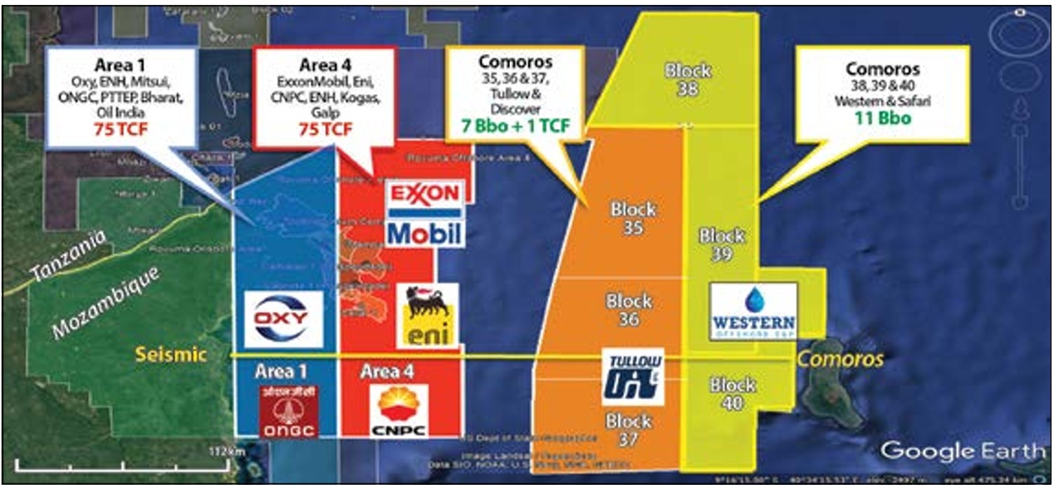
This success by key international oil players, like Anadarko, Eni, CNPC, ONGC and more recently ExxonMobil, Oxy and Total, has emboldened smaller, independent entrants to wade into deep water and to prospect for new giant oil resources down-dip from the gas discovered earlier. Today, the Comoros archipelago is abuzz with talk of new deep sea riches potentially lurking below in waters up to 3,000m deep, just waiting to be discovered.
Following publication of a new petroleum law in Comoros in 2012, new players including Bahari Resources, Discover Exploration and Western Energy East Africa Ltd joined the hunt. Discover was founded by the Cove Energy management that in 2012 had created almost two billion dollars in shareholder value via a sale to PTTEP of its stake in Mozambique Area 1, while Western Energy is famed for its earlier successes in unconventional oil shale plays in Colorado and California.
Thus a new era of modern seismic surveying was kicked off in the Comoros, with a grid of some 8,500 line-km 2D seismic data shot in 2014. This was tied to 20,000 line-km of Ion’s regional SPAN surveys, which had been shot in 2011 in East Africa over and surrounding several giant discoveries. The Bahari-Discover team licensed 2,330 km of the new Comoros 2014 infill 2D seismic over their 16,063 km2 three block area (Comoros 35, 36 and 37), while Western Energy East Africa licensed 744 line km of 2011 vintage and 3,134 km of 2014 data. The company holds the three blocks (38, 39 and 40) east of Tullow (formerly Bahari) / Discover’s area and currently operates 14,178 km2.
The bar was raised even further when superstar explorer Tullow Oil joined the party last year, fresh from earlier African successes in Uganda, Ghana, and Kenya and after extending its petroleum geology grasp further, into Guyana and Surinam in South America. Tullow took a 35% stake from Bahari and now operates for Discover.
Interesting Magnetic Anomalies in Comoros Subsurface Data
This is the first survey in the Comoros since Ion’s pioneering regional SPAN work in 2011 and the 2014 infill, which built upon earlier 1980s seismic reflection and refraction studies conducted on cruises aboard R/V Vema and Conrad by Columbia University’s Lamont-Doherty Geological Observatory. These, together with DSDP and ODP core-hole programmes, proved that the Somali Basin floor, on which the Comoros volcanic island archipelago grew, was made of thin ocean crust, and not continental crust as at Mozambique Area 1, which lies west of the Davie Fracture Zone. The ocean floor formed during seafloor spreading in the Late Jurassic to Aptian, as Madagascar and India moved 2,000 km southwards, away from East Africa, meaning that the oldest sediments on the ocean floor in the Comoros are Lower Cretaceous.
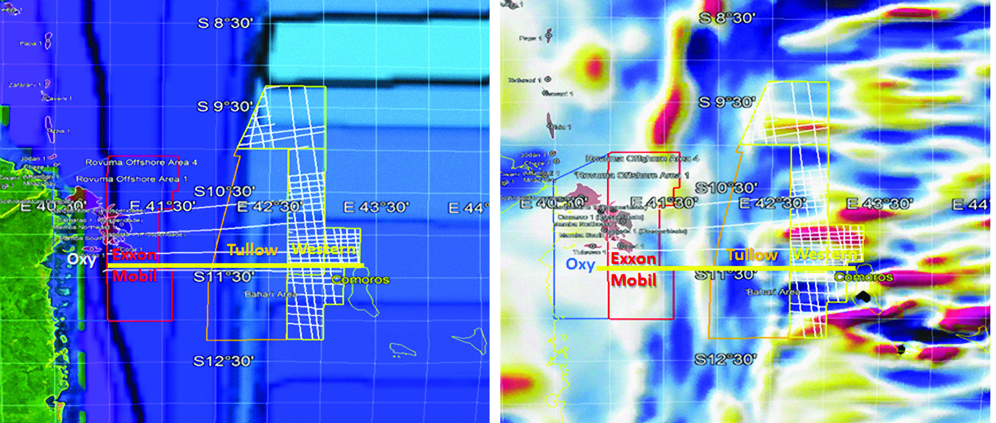
As a result, it can be seen that Area 1 in Mozambique is on continental crust and Area 4 straddles the Davie Fracture Zone, but everything east of that is oceanic crust. This is clearly demonstrated by lower frequency magnetic anomalies over continents compared with oceanic crust, and by gravity and refraction seismic survey results showing thin, shallow gabbro with 7 km/s velocity that are about ~10 km thick. Seismic reflection and refraction data show a shallow Moho with 8 km/s velocity below the thin ocean crust, fracture zones and transform faults.
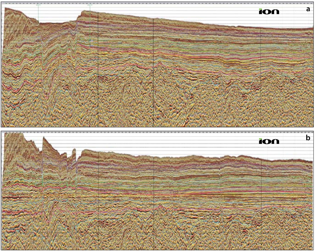
The basement below blocks 38, 39 and 40 is Lower Cretaceous ocean crust, with alternating east–west magnetic anomalies or ‘stripes’ in the ocean floor (see figure above), while the basement of the blocks to the west (35, 36 and 37) is the same but with the presence of well-developed transforms faults and fracture zones, some with as much as 2.5 km relief. New seismic (see figure opposite) shows ocean fracture zones bounding the first sediments to be deposited on the ocean floor, presumed to be of Lower Cretaceous age. Maps of seismic basement independently correlate directly with maps of magnetic basement. These Lower Cretaceous units are inferred to be restricted marine Type II source rocks and burial history plots show these today to be in the oil window in all the blocks. This offers a valid basis for Comorians’ hopes for offshore oil.
High Hopes for Hydrocarbon Potential in the Comoros
The igneous rocks in the Comoros Islands and surrounding seas are aged Miocene to present, which coincides with the onset of the East Africa Rift System, when asymmetric onshore rifts hosting deep anoxic lakes with Type I source rocks began developing. This is a modern analogue for Late Jurassic rifting of Gondwana, when similar lakes formed in Somalia, Mozambique and the Weddell Sea Basin. These later became restricted marine basins after Lower Cretaceous sea floor spreading, with Type II source rocks deposited during anoxic events. Sea floor spreading ceased in the Aptian, with a third post-spreading anoxic event possibly occurring in the Maastrichtian (Cohen et al., 2019).
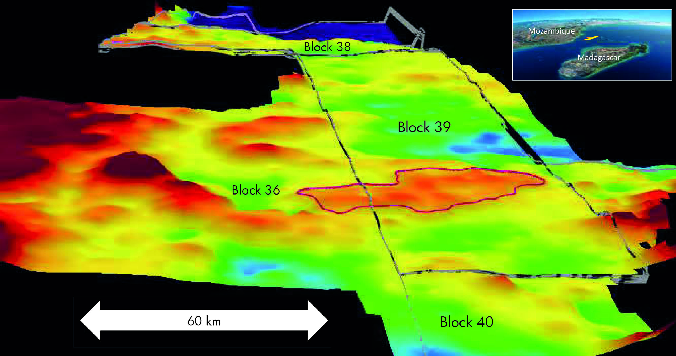
Comoros mapped prospects range in size up to 700 km2 (see figure opposite) and clearly straddle the boundary between blocks 36 and 39, showing similar trends and geology in deepwater Tertiary turbidite fans above the Lower Cretaceous oceanic basement. Many of these are associated with surface oil seeps detected by satellite synthetic aperture radar. In August 2019, Tullow began 3D surveying with the PGS vessel Apollo, and Western Energy East Africa have a 3D survey scheduled for 2020 that will cover 3,000 km2 – an area that is bigger than the cities of Delhi or Bangkok.
There appears to be considerable potential in these waters. A Competent Person’s Report produced on Tullow’s blocks 35, 36 and 37 estimated more than 7 Bbo and 1 Tcf of nonassociated gas was recoverable; Western estimates it has 11 Bb of recoverable oil reserves on its blocks. Taking Tullow’s and Western’s mid-case assessment together, this amounts to half the oil equivalent of the 200 Tcfg found to date in the offshore Rovuma Delta.
Today, Comorians’ hopes are high, as independent operators, seismic companies, news press and government have smelt the scent of the Perfume Islands and are on the hunt now for another essential oil: Texas tea, aka crude petroleum. The potential impact of any new-found wealth on the island’s society could obviously be huge.
References:
https://www.france24.com/en/20190522-dreams-comoros-oil-boom-hang-seismic-survey
https://www.discover-exploration.com/news/discover-exploration-farms-out-comoros-psc-to-tullow-oil
https://www.discover-exploration.com/assets/comoros-blocks-35-36-37
http://www.scotese.com/
https://www.geospace.com/
Cohen, C. R., Marshall, S. C., and Lovitz, G., Deepwater Oil Exploration and Prospects for Multi-Billion Barrel Discoveries, Comoros Blocks 38, 39 & 40, AAPG ICE, Buenos Aires, 2019.