La Brea Pitch Lake: The Largest Tar Pit in the World
The largest tar pit in the world, La Brea Pitch Lake in Trinidad, has a fascinating history and awaits approval as a Unesco World Heritage Site – even if it resembles a somewhat neglected car park!
I have been to more spectacular outcrops, I admit.
I am in the middle of what seems to be a somewhat neglected car park. The gently undulating black hardstanding is stretched and cracked as though from a long hot summer, yet elongate pools of water are suggestive of a recent rainstorm.
I feel curiously isolated in this quiet dead zone, yet the verdant fringe lies only a couple of hundred meters all around. I am standing on a large mineral bed. Oil is a mineral, isn’t it?
The Magic Lake
La Brea Pitch Lake (always ‘La Bray’ in Trinidad) is one of those places an oil geologist has heard of but does not quite know what to expect when they get there. Is it a glorified seep or an environmental disaster? The view on our arrival early one Saturday seems less than auspicious. Seen from the gentle hill above, it looks like a dry lake bed, and the tall reeds and grasses that surround it certainly don’t contradict this view. On the far flank, there seems to be some industry – warehouses, pipes and hoppers – but all is quiet today.
Mindful of the advice to avoid hustlers who might take advantage of our zeal to visit at all costs, Shazam and I had waited at the small car park until we saw a guide appropriately attired in an official red tee shirt and Cyrill Billy assigned himself to walk out with us. Of course, so as to justify his appointment, we are shown a faded photograph of an oil-covered man, zombie-like after rescue from the tar and presumed guilty of straying unsupervised from the route. The three of us walked through the curtain of sedge and out on to the tar field, Cyrill Billy recounting his well-rehearsed patter while prodding the ground with an umbrella.
Cyrill Billy prods the tar lake. © Tim Daley.
It is like soft tar. Indeed, it is soft tar. But it does not move or rebound and nor does it clag to your shoes. There is no particular odor; nor does it flow except in a few places where the surface skin is split, causing the gentle exuding of a rich black fudge. None can resist poking and probing at the wound and pulling the tar into extended tendrils of thick, viscous grease. There is a network of fissures that are mostly filled with water, and I am surprised to see the water is clear, with no slick, revealing schools of small fish suspended among a desultory fizz of bubbles. And just over there, as the tourist brochure claims, a family of ‘Trinnies’ (Trinidadians) are bathing, without fuss or demonstration, and presumably seeking the supposed restorative benefit of the sulfurous waters for their skin and bones.
And that’s it. The largest tar pit in the world awaits approval as a Unesco World Heritage Site in its quiet unassuming corner of Trinidad while it lays bare the oil history of this land. The magic is in that history: the industry it founded and the unseen thermoplastic properties of this mineral bed. According to Cyrill Billy, the 24 wagons of pitch that the Trinidad Lake Asphalt Company still scratches out from the surface every day and push up the hill for ‘refining’ are replaced each night and the lake surface healed by inflow. A mine that refills every night; now that really is magic.
Paved with Oil
Despite the economic interest and obvious focus for study, I am a bit unconvinced by the explanation for the pitch lake. It covers an impressive 100 acres or so (40 hectares) and is up to 250 feet (75m) deep, classically portrayed as a bowl shape. I have seen a cross-section, a detached figure I presume comes from an early 20th-century document, which appears to depict where the lake had been penetrated and records its reduction in size between 1893 and 1925. It is probably a breached oil field, now revealed as a massive seep, any light gassy fraction naturally venting away to leave a slow churn of biodegraded bitumen that appears to replenish over time. The proximity and intersection of two large faults is cited as facilitating the up flow, an association with faulting it may have in common with other well-known tar pits, including the identically named deposits in the suburbs of Los Angeles, which lie above the Salt Lake oil field and the 6th Street fault.
Source: P. R Woodside, U.S. Geological Survey Open-File Report 8l-660: Petroleum Geology of Trinidad and Tobago.
But why is a lake the result here? Oil seeps out at the surface all over the world but there are few tar lakes.
There is a small museum which may be open when you visit. We needed to ask for a Mr Carrington, museum curator and key holder, to come and open the center, but it was worth the wait. The display of glossy posters and artefacts is not overwhelming but it is well-presented and features the human history around the lake.
Every reference to the pitch lake is prefaced by the visit of Sir Walter Raleigh in 1595, who used this ‘black gold’ to caulk his boats on the way to search for El Dorado. Indeed, ‘brea’ is Spanish for tar, although the indigenous Amerindians use of the word ‘piche’ is closer to the word adopted by English speakers. The Spanish and then the British became aware of the properties of this flowing tar to smooth over uneven surfaces. A certain John McAdam was making roads in the mid-18th century from tightly packed broken stones, but in 1820 the addition of pitch led to the invention of ‘tarmacadam’ and a massive increase in demand for the asphalt, which has ‘paved’ the progress of Europe and America. I read in the museum how the 10th Earl of Dundonald, Thomas Cochrane, provided the money to form the precursor of today’s company to develop the field in 1851, but that it was Conrad Frederick Stollmeyer who managed the operation and further experimented with converting the tar into the kerosene known as ‘Trinidad Oil’. In the 1920s, more than 1,200 souls were laboring to dig up the lake, but by this time deeper sources of flowing oil were being discovered in Trinidad that would provide an abundant and frictionless source of kerosene and fuel oils.
Quarries to Castles
Stollmeyer: the name rang a bell. He was a German national, an emigrant to America, who when journeying to Venezuela was persuaded to stay in Trinidad by the opportunity presented by the pitch lake. Visitors to the Queens Park Savannah of Port of Spain might have noticed an eccentric mansion of that name, fashioned after a baronial Scottish castle – an ostentatious display of the wealth extracted from the south of the island. But the name also reminded me of a quarry, just a few miles south of La Brea, bisected by the Southern Main Road.
Stollmeyer’s Quarry: bitumen stained and seeping oil. © Tim Daley.
While puzzling over extending the life of the oil fields in south-west Trinidad with Trinity Exploration and Production, I had been invited on a field trip in which we examined the reservoirs exposed at the coast and in quarries. We had arrived at Stollmeyer’s Quarry late in the afternoon after a hard day’s geo-pondering; here was a great sand body cutting across its flood plain, crossbedded over its entire 15m height – and weeping oil from its bituminous face. The oil is not the focus of the quarry, the sand being extracted for road aggregate, but the location has been studied as an analog for an oil reservoir and how its resources are compartmentalized by subtle stratigraphic barriers.
Although the pitch lake is more famous, it is oil, and latterly gas, that has energized the Trinidadian economy. Oil company maps are peppered with closely spaced well penetrations and oil fields across the south are depicted as broad, continuous swathes, brushing over the intricacies of complex structures and multiple stacked sandstones. But the overall impression given is correct. Southern Trinidad is very oily. Everything that can hold oil does so and the overfill leaks to the surface.
The Source Up a Hill
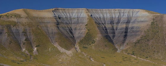
What is the source of all this oil? An unlikely outcrop of a world-class source rock is the centerpiece of San Fernando, southern capital of the island. A cone of pearly white rock, Naparima Hill, lends its name to the Upper Cretaceous rock formation, age-equivalent to the widespread and prolific Querecual Formation of eastern Venezuela which is responsible for that country’s vast oil reserves. This uplifted outlier is the evidence of what lies beneath the Trinidadian oil patch.
Lower slopes of San Fernando Hill and the Naparima Formation. © Tim Daley.
The view from San Fernando Hill looking across the Gulf of Paria. We can see the oil loading dock in the mid ground, and beyond that the chemical plants at Point Lisas. © Tim Daley.
When I jogged up the road to the small public park on the upper flanks of Naparima Hill and looked over the town and out across the Gulf of Paria, I did not really correlate the chalky looking cliffs with anything from which oil might have been sourced. But the shaded lower slopes of grey beds held more promise, based on comparison with my personal but unreliable atlas of source rock outcrops. Indeed, type rock descriptions from the Geological Society of Trinidad and Tobago describe bedded bituminous marls and shales while the upper parts are more of a silicified argillite. I should have wielded a pick hammer to expose the unweathered grey rock, and perhaps a whiff of hydrocarbons, but I left that untested honor to a literature search, which suggested 3–5% TOC from sampling.
But the age of abundance is coming to an end and even naturally refilling bitumen mines and super-sourced reservoirs are eventually emptied. One last look from San Fernando Hill shows the former Petrotrin refinery now quiet and unlit since its closure last year. It is being left to the small independent companies like Trinity to extend production life and keep the oil flowing long after the main harvest.
Further Reading on Oil and Gas Activity in Trinidad & Tobago
Some recommended GEO ExPro articles relating to oil and gas exploration in Trinidad & Tobago.
Oil and Gas Exploration in Latin America: From Shallow Shelf to Deepwater
Rog Hardy; Editor, NVentures Latin America Exploration Report
A brief overview of the history and future of oil and gas exploration in Latin America.
This article appeared in Vol. 16, No. 4 – 2019
Brief Biography of a Biogenic Gas Play
Rick Roberson, PGS
Recent commercial discoveries and modern 2D seismic in the Tobago Basin suggest that prolific natural gas reserves may extend far beyond the established trend and play concepts.
This article appeared in Vol. 8, No. 6 – 2012
The Deep Unexplored Waters off Trinidad, Tobago and Barbados
Scott Bowman Petrodynamics Inc., Ted Stieglitz Spectrum Geo Inc., Stephen Jagdeo
Re-imaged 2D regional seismic will lead to a better understanding of the Trinidad-Tobago and Barbados region and promising new opportunities in the search for hydrocarbons.
This article appeared in Vol. 9, No. 3 – 2012


