
Another piece in the complex Zambezi Delta puzzle
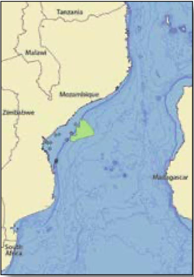
Addressing missing gaps with high-resolution gravity, magnetics and seismic data to aid in better understanding the geology of the Zambezi Delta Basin and its hydrocarbon-producing potential.
The structural configuration of the Zambezi Delta Basin provides evidence of a complex regional geodynamic evolution, with multi-phased plate tectonism and reconfiguration. The complexity of restoring the western Indian Ocean to its original configuration lies in the scarcity of M-series anomalies (those observed on the ocean floor and indicating oceanic crust) recorded during the Late Jurassic to Early Cretaceous.
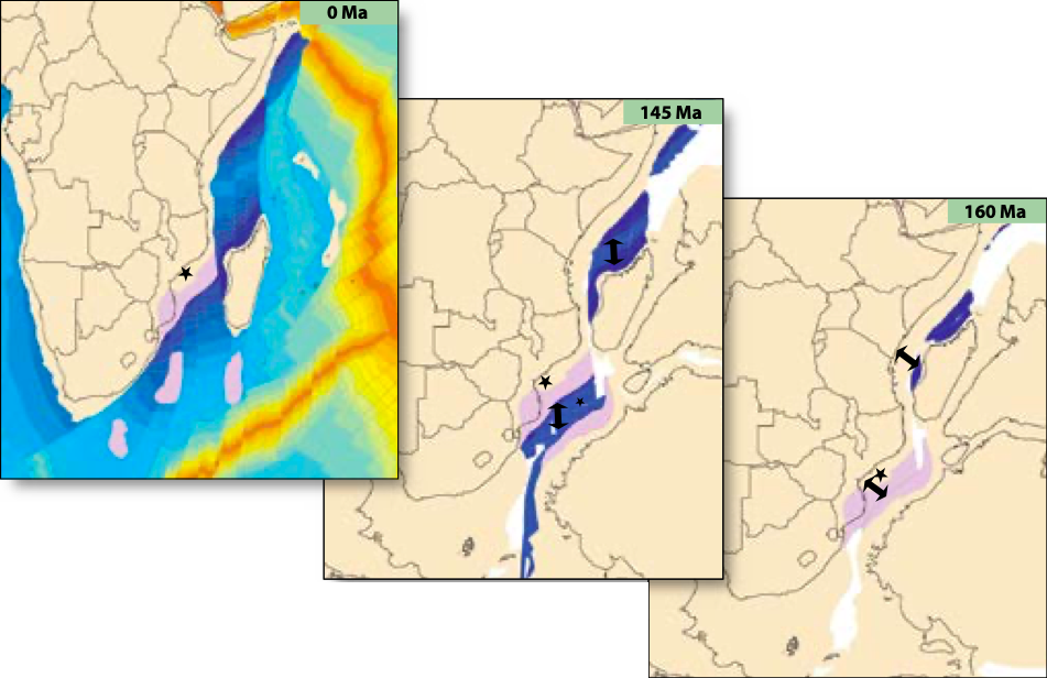
The Zambezi Delta Basin is one of the oldest offshore basins in the East African margin, formed as a consequence of the onset of an Early Jurassic rifting and subsequent breakup of eastern Gondwana. Its two-phase breakup with different stretching orientations triggered the formation of the African-Antarctica corridor, separated from the Somali Ocean by activation of the Davie Fracture Zone during the late Jurassic (Figure 2).
Gravmag data reveals structural information of the Zambezi Delta Basin
The area’s crustal nature and distribution across the basin was inferred from analysis of the high-resolution gravity and magnetics (gravmag) data and derived attributes acquired by CGG in 2017, which were also modeled in 2D cross-sections. Cross-correlation with the seismic data from CGG’s multi-client survey underlines the structural dimension of the basin’s geological characteristics.
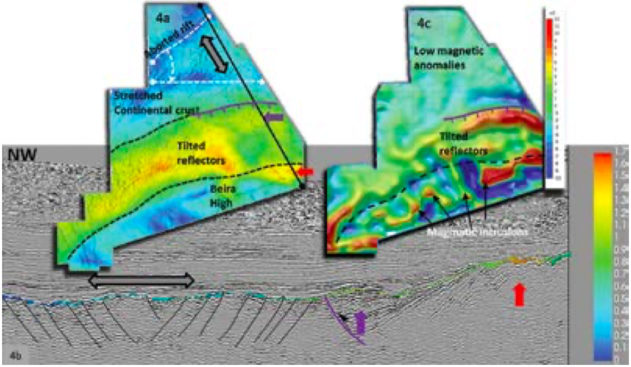
The Bouguer gravity map shows a low over the Beira High, a north-east to south-west elongated structural feature located offshore that extends for more than 150 km. The horizontal gradient of the Bouguer gravity shows highs along the edge of the Beira High as well as in the north of the survey area (Figure 4a), where a north-east to southwest rifting geometry is observed. Cross-correlating this map (blended with the top synrift structural map) with a seismic section confirms the extensional character of this geometry (Figures 4a and 4b).

The magnetic anomaly map differentiates between two main domains (Figure 4c). The northern domain, which is relatively quiet magnetically, shows low-amplitude non-coherent magnetic anomalies over the deeper basin. Conversely, the southern domain is characterized by two distinct magnetic anomaly orientations associated with the Beira High. One is observed over its northern flank, and the other, a set of north-west to south-east anomalies, within its internal architecture.
The complete basin picture
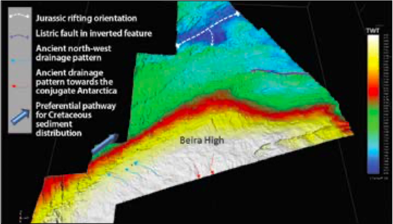
Insight from gravmag and seismic data confirms the continental origin of the Beira High. However, the origin and crustal nature of the northern area has historically been a matter for discussion. The evidence provided in this article suggests a stretched continental origin, with a north-east to south-west aborted rifting geometry located to the north of the survey. The synrift structural map indicates a clockwise rotational component (Figure 5).

Volcanism in the area played an active role in the basin’s configuration, with at least three relevant magmatic events identified. Locally, remnant magnetization was identified in the magnetic anomalies within the Beira High, suggesting magmatism during different magnetic pole orientations. The magmatism can be characterized by three separate events, although it would be more accurate to understand these events as part of a continuous evolution of the margin (Figure 3).
Firstly, there was an early Jurassic event, related to the start of regional north-east to south-west rifting. Late Karoo volcanism provided a considerable volume of mafic material along the northern flank of the Beira High. Some authors describe these geometries as seaward-dipping reflectors. However, magnetic depth estimates suggest a deeper origin.
A second event, identified from lava flows and intrusions interpreted on the seismic data, occurred along the north-east to south-west graben structures of the failed rift morphology. This event could be related to the reconfiguration of stress regimes and rotation during rifting evolution. Stress field orientation developed from north-west–south-east to north–south, favored by the onset of the Davie Fracture Zone and the opening of the Somali Basin. The Beira High acted as a backstop for continued rifting, which shifted south-eastwards with accretion of oceanic crust identified from M-anomalies south of the Beira High.
The third magmatic event is observed as sills in the seismic data, intruding the Early Cretaceous section. These are interpreted as resulting from late crustal readjustments and the reactivation of faults and flexure during the sag phase, resulting from thermal relaxation after the rift axis shifted to the south-east of the Beira High.
Beira high influences sediment distribution
Seismic data analysis reveals that the configuration and location of the Beira High during Early to Late Cretaceous times played a crucial role as a barrier for sediment distribution and its confinement along the basin. The crustal density contrast between the continental Beira High and the oceanic crust induced a buoyancy effect and a gradual uplift. Simultaneously, conditions for a rimmed carbonate platform were established on the inner western flank of the Beira High and subsequently more than 11 km of Mesozoic to Cenozoic sediments were deposited within the basin. Deep marine channel systems, together with mass flow processes, are the predominant mechanisms for sediment distribution within the basin. Observations from seismic attribute maps provide evidence of a south-west to north-east system of meandering channels developed from the early Cretaceous, which evolved to a west–east orientation during the Late Cretaceous and then a north-west to south-east orientation during the Cenozoic (Figure 6).
Figure 6: Set of RMS attribute maps from Early Cretaceous to Mid Tertiary. Note the evolution in orientation and morphology of the channels conforming to the intervals analyzed. The Late Cretaceous interval (green maps) shows a prominent mass transport complex (MTC) developed (dashed white line ). The MTCs are dominated by localized erosion, possibly turbidity-induced channel systems flowing from west to east. The lighter map shows the orientation and geometry of the deep marine channels related to the dynamics of the Zambezi River during intra Oligocene. (6a): Angle of evolution of the main flowing system for each of the analyzed intervals.
The present-day Zambezi Delta has been active since the Early Cenozoic and has a sedimentary thickness of over 4 km. Analysis of the Tertiary channels and their geometry, distribution and orientation variations provides evidence for close interaction between eustatic sea level and the Oligocene regional uplift event (Figure 6a).
A more comprehensive geological understanding of the Zambezi Delta Basin
CGG’s high-resolution 3D seismic survey further revealed potential prospective structures within the Zambezi Delta Basin. Widespread amplitude anomalies are evident as pinch-outs or within channels in the Cenozoic and Cretaceous sections.
Understanding the initial stages of the basin’s tectonostratigraphic evolution is fundamental to infering its hydrocarbon prospectivity. The mid-late Jurassic on the Beira High is dominated by the presence of rotated fault blocks with possible deposition of terrigenous sediments. The resulting carbonate platform would have been conducive for the development of both source rocks and reservoir facies.
The Cretaceous is dominated by the deposition of clastic sequences. The upper and lower Domo shales (Cretaceous source rocks) were deposited during a period of marine transgression and anoxia. The lower Cretaceous reservoirs are represented by the Maputo and the Domo sands. The Late Cretaceous reservoirs are represented by the Grudja Formation, possibly deposited by basin floor fans and channels. The Eocene-Oligocene reservoirs are represented by the Cheringoma Formation. Late Oligocene to Miocene reservoirs are well defined within the Zambezi Delta complex. Potential traps include structural as well as stratigraphic mechanisms (pinch-outs onlapping onto the Beira High, truncations against unconformities and channel fills). Seals will predominantly be intra-formational within the Cretaceous and early Cenozoic section.
Despite the presence of a promising and technically proven petroleum system in place, no significant oil or gas discoveries have been made in the basin. This could simply be a result of low drilling density in such a large basin. Predictions do, however, suggest significant potential in this basin.
References
Schenk, C.J., 2012, An estimate of undiscovered conventional oil and gas resources of the world, 2012: U.S. Geological Survey Fact Sheet 2012–3042, 6 p.


