The Hydrocarbon Potential of the Dominican Republic
The Dominican Republic has just announced its first licensing round, which concludes in December 2019. With fourteen blocks available on and offshore, a flexible contract and an attractive investment environment, the nation is set to open up the Caribbean to new oil and gas exploration opportunities.
The geological setting and a history of drilling and oil seeps in this frontier region gives investors and operators plenty of reasons to be attracted to the Dominican Republic. Major features of note in the structural setting include:
Subduction of the North American plate below the Caribbean Plate;
Strike-slip convergent structures produced by strike-slip displacements and transpressional accretion of crustal fragments (Mann & Lawrence, 1991);
Thrust belts developed on both sides of oceanic island arcs;
A north-verging accretionary prism lying to the north of the Eastern Greater Antilles arc.
The geological setting of the Dominican Republic. ALA: Arch of the Leeward Antilles, BhB: Bahía Basin, ColB: Colombia Basin, CF: Cuiza Fault, SCTB: Southern Caribbean Thrust Belt, NPTB: Northern Panama Thrust Belt,, RB: Ranchería Basin, MaB: Maracaibo Basin, TaB: Tairona Basin, SJTB: San Jacinto Thrust Belt, AR: Aves Ridge, BR: Beata Ridge, TB: Tobago Basin, VB: Venezuela Basin, DM: Magdalena Delta, HE: Hess Escarpment, AF: Ancón Fault, BF: Boconó Fault, OF: Oca Fault, SS-EPF: San Sebastián – El Pilar Fault, GB: Grenad Basin, SM: Santa Marta Massif, BAP: Barbados Accretionary Prism, GP: Guajira Peninsula, PP: Paraguaná Peninsula, SP: Serranía del Perijá, PBFZ: Pedro Baal Fault Zone, ASZ: Antilles Subduction Zone, VA: Venezuela Antiles, LASZ: Lesser Antilles Subduction Zone. STB: Sinù Thrust Belt.
The Dominican Republic occupies the eastern five-eigths of the island of Hispaniola, in the Greater Antilles archipelago of the Caribbean region. It is the second largest Caribbean nation by area, and the third by population. Its capital, Santo Domingo, is home to approximately three million people.
As the most visited destination in the Caribbean, the Dominican Republic is known for its beaches, resorts and golfing. It has geographically diverse terrain, with rainforest, savannah and highlands, including the Caribbean’s tallest mountain, Pico Duarte, and the Caribbean’s largest lake and lowest point of elevation, Lake Enriquillo. With temperatures averaging 26°C (78.8°F), and wide climatic and biological diversity, the nation has long been a favourite with tourists from all over the world. In addition, the Dominican Republic is an attractive and desirable country for international investment that goes beyond known tourism.
Structural main features of the Caribbean on the General Bathymetric chart of the oceans (GEBCO). Source: Neoil Exploration.
The presence of crude in the Dominican Republic has been known for decades, as evidence by the black gold that oozes out of a pit in Charco Largo, Azua, in the south of thet country. Three onshore Neogene clastic basins have been the focus of petroleum exploration, and oil seeps led to a well being drilled at Higuerito as long ago as 1905, which reportedly produced about 40 bopd, although sustained production was not obtained until 1927/8 by Texas Co.
A time line of hydrocarbon exploration in the Dominican Republic. (modified from Mann and Lawrence, 1991).
The Dominican Republic: A Significant Frontier Basin Opportunity
There are four basins of interest in the Dominican Republic:
the Cibao Basin;
the Enriquillo Basin;
the Azua Basin;
the San Pedro de Macoris Basin.
Conventional exploration in frontier basins has been shown to deliver stronger results than in emerging and mature basins. For early entrants, this delivers the most value – most commercial volumes discovered are through frontier exploration.
On offer in these four basins are fourteen blocks, both on and offshore, with a maximum size per block of 500 km2 onshore and 2,500 km2 offshore. Onshore, six blocks are available in the Cibao Basin, three in the Enriquillo Basin and one in the Azua Basin. The four offshore blocks are all located in the San Pedro de Macoris Basin.
In addition, interested companies will be able to nominate new exploration areas and/or propose changes to future blocks on the back of success in this round. Flexible contract terms allow operators to adapt the exploration strategy during the term of the contract.
Blocks on offer in the Dominican Republic first licensing round. Source: Wood Mackenzie.
The Cibao Basin
The Cibao Bain, located in the north of the country, has six onshore blocks available. It covers an area of 6,946 km2 and is an asymmetrical strike-slip basin. Approximately 23% of the basin has 2D seismic coverage, a total of 632 line-km. Sixteen wells with four gas shows have been drilled and there are two known oil seeps in the basin. Modern technology has the potential to improve historical information; however, seismic shows a highly deformed basin with high-angle transpressive faults, positive flower structures and anticlines, all identified as potential structural traps.
Geological map of the Cibao Basin.
Stratigraphic column of the Cibao Basin showing tectonic events, petroleum systems and three identified plays. Source: Modified from Tillman, 1991 – Mann & Lawrence, 1991.
In the Cibao Basin the Tabera Group is a hypothetical source rock, which has been in the oil window since the late Oligocene and would have reached maximum peak generation during the Miocene. Based on TOC interpretation of logs from well San Francisco-1 there are also potential source rocks in the Guarabo Formation. The same well has evidence of good reservoirs along the Miocene and Pliocene, which are also seen at outcrops. These are sealed by Oligocene and Pliocene siltstones and clays.
There are at least three different plays and several potential prospects in the Cibao Basin. The petroleum system shows type III gas-prone kerogen (Tillman, 2015) and a pseudo-well shows the Tabera Group entering in the oil window.
The Enriquillo Basin
The Enriquillo Basin, where three onshore blocks are available, is located in the western part of the Dominican Republic. The basin area is 3,100 km2 and it is a synclinal, upper Miocene to recent sedimentary ramp basin (Mann et al., 1991). Seismic coverage is approximately 90%, with 1,007 km of 2D in 65 seismic lines. Nine wells have been drilled, four having had gas shows, and two oil seeps and one gas seep have been identified. .
Geological map of the Enriquillo Basin.
Stratigraphic column of the Enriquillo Basin showing tectonic events and petroleum systems. Source: Modified from Tillman, 1991 – Mann and Lawrence, 1991.
Three source rocks have been defined. These are the Trinchera Formation in the early oil window towards the central part of the basin; the Sombrerito Formation in the early to middle oil window; and the Plaisance Formation in the late oil window and early gas window. These reached the early stage of generation during the Eocene and maturation continued during the Neogene. Outcrops and wells have shown reservoir potential in Eocene rocks, possibly the Oligocene and also at Miocene level in the basin, while shales at several levels in the Eocene to Pliocene are expected to act as seals.
Enriquillo is a highly deformed basin with high angle transpressive faults and salt-related and thrust structures, and there is also potential for carbonate and reef-associated reservoirs.
Several undrilled prospects have been identified, and there are at least three plays in the basin. The petroleum system indicates potential for biogenic and thermogenic gas in the Trinchera Formation.
The Azua Basin
The Azua Basin is located in the south-west of the country, and there is one onshore block available. It is a synclinal, Upper Miocene to recent sedimentary ramp basin (Mann et al., 1991) covering 795 km2 and approximately 10% of the basin has 2D seismic coverage, with 42 km in 9 lines. A total of 58 wells have been drilled in the basin and four have gone into production, while another 14 had oil and/or gas shows. There are also three significant oil seeps. Modern technology has the potential to improve historical information, but a number of interesting trapping structures have already been identified.
Geological map of the Azua Basin.
Stratigraphic column of the Azua Basin showing tectonic events and petroleum systems. Source: Modified from Tillman, 1991 – Mann and Lawrence, 1991.
Shales from Neiba and Trinchera Formations are expected to provide the hydrocarbons, while the Jura Formation is hyperthetically an additional source, considered to be at maximum peak of generation. Reservoirs comprise the conglomerate facies from the Ocoa Formation, as well as sandstones from Trinchera and Arroyo Blanco Formations, sealed by Sombrerito Formation marls and shales from the Arroyo Blanco Formation. Seismic shows a highly deformed basin with high angle transpressive faults, positive flower structures and anticlines – all potential structural hydrocarbon traps.
The Azua Basin is a proven petroleum system with two existing fields.with 20° API oil being produced from the Miocene Arroyo Blanco Formation. To date 13 Mbo has been produced from Maleno-1, 5 Mbo from Maleno 1A and 5 Mbo from the LYK well. These fields are no longer producing, but demonstrate that there are commercial quantities of hydrocarbons to be found.
The St Pedro de Macoris Basin
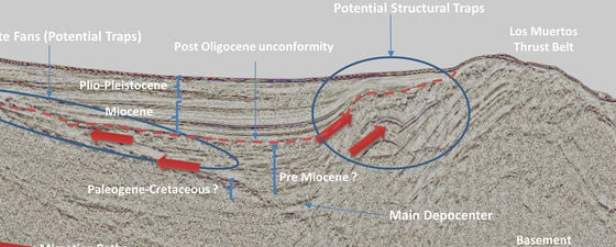
The St Pedro de Macoris Basin is the only offshore basin, and is located to the south of the Dominican Republic. There are four blocks available. It is a fore-arc basin and covers 10,339 km2. Approximately 67% of the basin is covered with 2D seismic, 1,898 line-km in 127 seismic lines. No wells have as yet been drilled offshore but three have been drilled on the onshore part of the basin, known as the Llanura Oriental Basin. San Pedro-1 showed paraffin and light oil at 30° API, and seismic shows potential structural traps, including pinch-outs and turbidite fans.
Seismic line with petroleum system elements. Source: Neoil Exploration.
Attractive Oil and Gas Opportunities in the Dominican Republic
Dominican law establishes equal treatment for all domestic and foreign investors, allowing the participation of international companies in all economic sectors, excluding defence and national security. Investors will have access to preferential markets through free trade agreements, including the Agreement of Economic Association with the European Union and the Dominican Republic-Central America Free Trade Agreement. Its location in the Caribbean means that the Dominican Republic is an important commercial link between Europe, North America and the rest of Latin America.
The Dominican Republic therefore offers an attractive investment environment, underpinned by strong and sustained economic growth. Upstream investment will beneft the country with greater development, technical know-how, new business for local firms and create more and better paying jobs. Diversifcation of the economy will help to protect the economic viability of other important sectors, such as industry and tourism, and create a sustainable cycle of economic activity.
Further Reading on Oil and Gas in the Caribbean
Buried Treasure in Jamaica
Chris Machette-Downes
The beautiful Caribbean Island of Jamaica was home to pirates and their loot in the past, but is there treasure of a different sort in its sparkling waters? Data collated for a new bid round, due to close in March 2011, suggests that there may well be.
This article appeared in Vol. 7, No. 6 – 2010