Exhumed Portuguese Oil Field Suggests Hydrocarbon Potential in Conjugate Newfoundland Basin
The discovery of an exhumed oil field in the central Lusitanian Basin in Portugal has significantly enhanced the hydrocarbon potential of Lusitanian and Peniche Basins and the conjugate Carson-Bonnition Basin in Newfoundland.
Location map for the central Lusitanian Basin showing the São Pedro de Moel diapir location. The dark grey areas show salt structures and the black areas are outcrops of evaporites. Coloured map shows the São Pedro de Moel oilfield (green) wrapped around the salt diapir (pink). © Earthmoves.
The Lusitanian Basin is part of the Central Atlantic rifting system which started opening between Late Triassic and Early Jurassic times. Hettangian-age salt was deposited during the rifting event, salt diapirs initiated soon afterwards.
Salt diapir growth continued thoughout the Jurassic and Cretaceous. Alpine compression from Late Cretaceous to the present day caused squeezing of the diapirs and produced folding of the adjacent overburden.
The Lusitanian Basin has been extensively explored for hydrocarbons over the past 80 years, with 135 exploration wells drilled, predominantly onshore, yet no commercial oil has been discovered, and it has been questioned whether a viable petroleum system exists.
Sao Pedro de Moel Salt Diapir Oil Field
Recent field work at Praia de Paredes de Vitória and Pedras Negras (black rocks) has revealed the existence of an important exhumed oil field, that has now biodegraded to bitumen. These two key outcrops occur at both ends of the oil field, which is trapped against an elongate salt diapir. Unfortunately, the inland area has very little outcrop and is now inaccessible following an extensive forest fire in October 2017, which left many tall tree trunks standing precariously, making it a ‘no-go’ danger area. Nonetheless, the information collected from vintage geological survey maps, together with exploration well data available around the diapir, provide a good control of the diapir’s lateral extent, eastward and westward.
The Azeche Mine at Praia de Paredes de Vitória was exploited for tar from the 1840s into the early 20th century. At least 507 tonnes of bitumen were mined here (Rodrigues, 1934). The tar sands and dolomites from this mine were used to surface the first asphalted roads in Lisbon and paved railway stations across the country. The mine lies on the southern contact of the São Pedro de Moel salt diapir and the location is therefore well known as an oil seep – but it is of much greater significant than this.
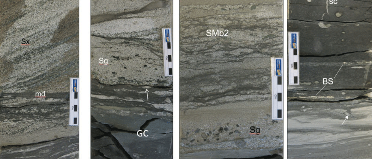
As can be seen in the image below, the sea cliffs at Praia de Paredes de Vitória expose a 50m vertical column of tar-saturated sandstones. The upturned hydrocarbon reservoirs extend for at least 350m southwards away from the east-west trending, vertical diapir wall before plunging below beach level. A minimum net reservoir thickness of 15m is present at the highest point adjacent to the diapir, and the sandstone units thicken downdip. The sandstone reservoirs weather to a white colour, but are black on fresh surfaces. Intervening tar-soaked shales are greenishyellow on weathered surfaces due to growth of native sulphur, which is a by-product of oil biodegradation, giving a striking stripy appearance to the outcrop.
Praia de Paredes da Vitória
Panorama of the Praia de Paredes de Vitória outcrop with stratigraphic units and unconformities highlighted. This whole cliff face is impregnated with oil below the Eocene unconformity. Inset photo shows the beautifully-crafted entrance to the Mina de Azeche asphalt mine within the diapir.
© Ian Davison.
Two unconformities are exposed adjacent to the diapir (see photo above). The lowermost unconformity is probably Cenomanian in age and is caused by uplift of the salt diapir and subsequent erosion. Steeply-dipping (>70°) Aptian to Albian sandstones and Cenomanian limestones and conglomerates are overlain by shallow-dipping (<20°) Turonian-age, shallow marine sandstones. The age of the unconformity indicates that the diapir was growing at this time, which was well before the Alpine compression initiated. Seismic and field data also indicate the diapirs were growing during Jurassic sedimentation. The upper unconformity is more regional, where Eocene-age red and grey marls and claystones overlie older Maastrichtian to possibly Palaeocene sandstones with little or no angular unconformity. These Eocene rocks act as the top seal to the oil reservoirs, indicating that active oil migration must have occurred in post-Eocene times. Oil probably migrated up and along the diapir contact and then backfilled downward and outward into the adjacent reservoir sandstones.
The small quarries at the northern end of the salt diapir at Pedras Negras beach expose black tar-saturated highlysheared dolomitic and gypsiferous shales, which form part of the main diapir. These are overlain by tar-impregnated Jurassic marls. It is not clear whether these lie within the diapir or in the immediate overburden. However, it is apparent that this exposure is situated within the main hydrocarbon migration pathway along the diapir contact.
Detail of the upturned Albian and Aptian interbedded sandstones and marls trapped against the diapir. One of the Mina de Azeche galleries is indicated by a rectangle. The arrows indicate fresh patches of exposed tar-stained sandstones which are almost black. © Ian Davison.
The proposed mapped outline of the diapir relies on outcrop information from the Geological Survey of Portugal and our own mapping. Based on the closure area we calculate that the field contains a minimum of 85 MMb of biodegraded oil, and probably significantly more, as deeper buried reservoirs are likely to exist below sea level. Furthermore, the upper part of the oil field may have been removed by the significant Alpine erosion in this area.
The syn-rift Sinemurian- to Pleinsbachian-age shales are the most likely source of the oil. These are particularly rich in the adjacent withdrawal synclines on the flanks of the São Pedro de Moel diapir, and reach up to 15% total organic carbon content. At least three different organic-rich intervals, with a gross thickness of 80m, are present at outcrop (Duarte et al., 2010).
However, the most productive gallery in the Azeche Mine was driven into dolomitic bituminous shales (Hettangian Dagorda or Sinemurian Coimbra Formation) within the diapir near the southern contact, where there is a well preserved mine entrance dated 1857 (Rodrigues, 1934; Morais, 1936). This suggests that source rocks are also present in the Dagorda Evaporites. BEICIPFRANLAB (1996) reports up to 3.25% TOC within Dagorda marls from data collected both from outcrops and well data (both onshore and offshore).
Implications for Hydrocarbon Potential in the Newfoundland and the Peniche Basin
Approximate fit (adapted from Alan Smith, Cambridge University) between Portugal and Newfoundland during rifting showing the Lusitanian Basin was conjugate to the Carson-Bonnition (C-B) Basin. Salt basin outlines and individual salt structures shown in black. The Berlengas Horst (pink) separates the Peniche Basin from the Lusitanian Basin. © Earthmoves.
The conjugate Carson-Bonnition Basin in Newfoundland is approximately 160 km long and is a deep Early Jurassic salt basin with up to 7 km of mainly Mesozoic sediment fill. Three wells have drilled down to the Upper to Middle Jurassic strata on the shallow shelf, but no source rocks were encountered (Wielens et al., 2006). No wells have been drilled in the deeper, more prospective parts of the basin where better source potential can be expected in the Jurassic-age withdrawal synclines in between the large salt structures. This has left a large question mark regarding the source rock potential of this underexplored basin, despite the fact that it lies only some 100 km south-west of the prolific Jeanne D’Arc Basin (see figure left). This is a similar situation to the deepwater Portuguese Peniche Basin which is still undrilled, although recent 3D broadband seismic data coverage indicates the presence of many salt structures with a similar structural style, and consequently there are many potential leads.
The Lusitanian and Carson-Bonnition Basins were in close juxtaposition during the Early Jurassic, when viable source rocks, now proven, were deposited in the Lusitanian Basin. The discovery of a significant oil field in the Lusitanian Basin greatly enhances the hydrocarbon potential of the Peniche and Carson-Bonnition Basins. ExxonMobil recently acquired a large block in this basin. On 3 April 2019, the Newfoundland and Labrador Offshore Petroleum Board announced a Call for Bids, offering nine parcels covering most of the remaining prospective acreage, with applications due on 6 November 2019.
A very timely offering considering this recent discovery on the conjugate margin!
Further Reading on Oil and Gas Activity in Portugal and Newfoundland
Some recommended GEO ExPro articles relating to oil and gas exploration activity in Portugal and Newfoundland.
Promising Portugal
UPEP/ENMC
Good sediment thickness; multiple trapping mechanisms; excellent energy-hungry markets nearby; and large areas available for leasing: time to take a look at underexplored Portugal.
This article appeared in Vol. 13, No. 2 – 2016
Beneath the Labrador Sea
Kai Floistad, Jerry Witney, Ron Borsato, James Carter, Richard Wright & Thomas Neugebauer
A new seismic dataset helps clarify the deepwater hydrocarbon potential offshore Newfoundland and Labrador in Canada.
This article appeared in Vol. 10, No. 2 – 2013
The Other North Atlantic
Thomas Smith
Canada’s offshore oil and gas industry was born off the coasts of Newfoundland and Nova Scotia and is seeing promising signs of a rebirth.
This article appeared in Vol. 8, No. 2 – 2011