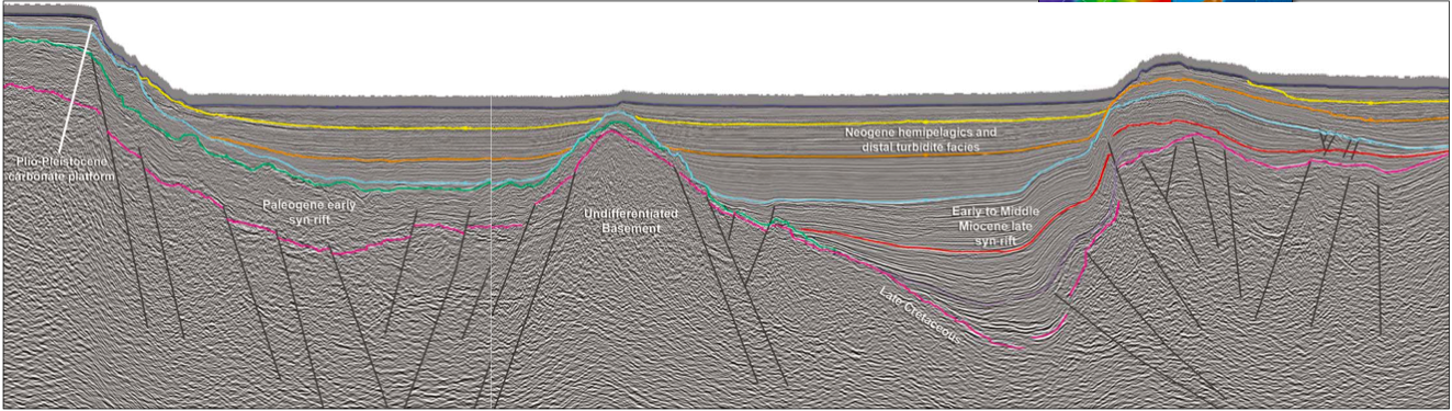
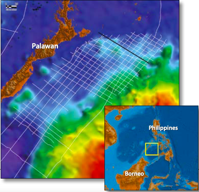
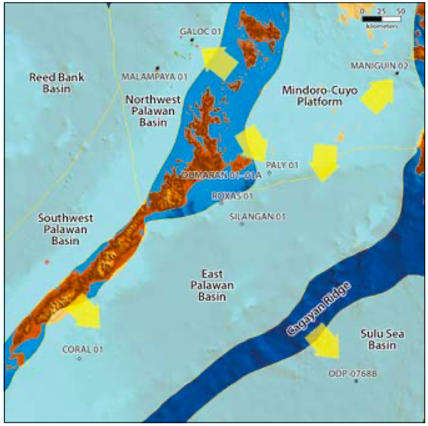
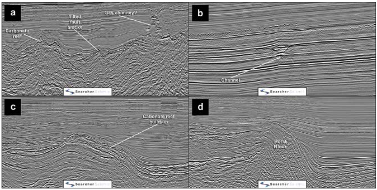
The Philippines has had some significant petroleum discoveries to date, with several important producing fields in the Northwest Palawan Basin. Just around the corner lies its sibling, the East Palawan Basin, which is devoid of any hydrocarbon discoveries or producing fields. This does not make sense as the East Palawan Basin has shared much of the same sediment provenance as the Northwest Palawan Basin through time. Searcher Seismic, in cooperation with the Philippine Department of Energy (DOE), has acquired over 8,500 km of long-offset, PSDM processed 2D seismic data in the East Palawan Basin. The interpreted line below is oriented north-west to south-east and highlights thicker sedimentary sections than the producing Northwest Palawan Basin, as well as previously unidentified subbasins in the area (e.g. the Mialara Sub-basin). With the approaching Philippine Conventional Energy Contracting Program (PCECP) bid round, these datasets are revealing new hydrocarbon potential and highlighting the prospectivity of the East Palawan Basin, which makes for an exciting future for exploration in the Philippines. Insights from the only five wells drilled to date, together with modern seismic data, reveal that there is still much to be unraveled in the East Palawan Basin. Much of the Philippines is characterized by mobile arcs, accretionary terrains and spreading centers. However, the western Philippines is underlain by Sundaland continental crust (Metcalfe, 2017). Palawan and its surrounding basins rifted and separated from southern China during the opening of the South China Sea in the Oligocene and Early Miocene. It is this period that much of the exploration efforts have been focused on; i.e. Oligo-Miocene carbonate plays such as the Malampaya Field. In 2014, Searcher Seismic acquired the Mialara 2D seismic survey to provide long-offset, high resolution seismic data over the East Palawan Basin to help identify prospective stratigraphic and structural trends, as well as tie the wells and the previously acquired Pala-Sulu 2D seismic survey (see map on main foldout page). The Mialara data addresses multiple issues with the vintage data in the area by using a 10 km streamer with improved frequency response, a larger source array for improved signal penetration, and a broadband anisotropic PSDM processing workflow. The East Palawan Basin, when compared to its producing sibling the Northwest Palawan Basin, remains an enigma, as it is devoid of any hydrocarbon discoveries or producing fields. With only five wells drilled in the area, as shown on the structural elements map, the basin remains underexplored. The majority of the wells in the East Palawan Basin were drilled in the 1970s and early 1980s, in general chasing Miocene objectives, although most resulted in dry holes. Perhaps the most intriguing of them is Dumaran-1 (1979, Citco Philippines Petroleum Corporation) as this flowed gas to surface and revealed traces of dead oil at depth. This suggests that up-dip migration from the deeper parts of the basin could be feasible. Dumaran-1 ultimately terminated in pre-Cretaceous ultramafic basement rocks. The most recent well was drilled by Shell in 2010 (Silangan-1). The well was chasing a turbidite flat spot objective, but post-drill analysis showed limited reservoir development. The flat spot was interpreted as a slump and the well, which terminated in the Middle Miocene, was plugged and abandoned as a dry hole. Sandwiched between the Northwest and East Palawan Basins lies the Mindoro-Cuyo Platform. Insights from the only five wells drilled to date, together with modern seismic data, reveal that there is still much to be unraveled in the East Palawan Basin. The platform contains several rift-related grabens that appear to have a similar late Paleogene history to the Northwest Palawan Basin and its known oil and gas producing areas (Ballesteros and Robinson, 2012). During the Neogene, their development changes and is analogous to the depocenter associated with the Maniguin oil discovery. The only available data are from the four old wells on the basin margin. Excluding Silangan-1 (Shell, 2010) which is in a more basinal location and terminated in the Middle Miocene, the wells in the Mindoro-Cuyo Platform arguably provide the closest useful data. The Maniguin-2 well was drilled in 1994 by PNOC on the eastern flank of the Mindoro-Cuyo Platform and flowed 300 bopd of waxy oil from a Lower Miocene sandstone reservoir (the Semirara Formation). Post-well analysis suggests that the Miocene source rocks and reservoirs were deposited under paralic to shallow marine conditions (Forbes, 2002). Lower to Middle Miocene sandstones in adjacent wells (Semirara-1 and Maniguin A-1X) also have high porosities (9–31%) and permeabilities (<1,070 mD). Is it feasible that this source-reservoir interval exists towards the Mindoro-Cuyo Platform’s southern margin (and the East Palawan Basin)? Distributary channel facies are observed in the Neogene section throughout the Mialara data, including channels with differential compaction evidencing coarse clastic channel fill (see b above). This suggests that Miocene sandstones like those encountered in Maniguin-2 have been delivered into the East Palawan Basin from the Mindoro-Cuyo Platform and Palawan areas. The Mialara data allows mapping of several rift-related grabens across the East Palawan Basin, some of which reach up to 7 km of burial which is likely to be buried to sufficient depths for the generation of hydrocarbons. Some grabens appear to be filled primarily with Paleogene early syn-rift sediments, while others are predominantly filled with late syn-rift Neogene fill. The Dumaran-1A well recovered gas to surface and encountered common traces of glutinous black tar with bright yellow cut fluorescence only, suggesting a working petroleum system in the area. Calibrating the heat flow and thermal history data from Maniguin-2, Searcher Seismic has produced a burial history model for the Mialara Sub-basin. This puts the Lower Miocene source in the late oil-gas window in the deepest part of the basin, which provides an encouraging benchmark for the other (deeper) parts of the basin. The area has also demonstrated good quality reservoir characteristics. The Roxas-1 well was drilled in 1979 by Citco Philippines Petroleum Corporation and encountered porous Middle Miocene sands (from 823 to 1,220m). ODP wells drilled as part of Leg 124 encountered Middle Miocene quartz-rich, continental-affinity turbidites, demonstrating that long distance transport during this period is feasible, the source of the sediments most likely being the Cagayan Ridge to the west. Additionally, undrilled Miocene carbonate reef facies, analogous to the Nido Limestone targeted in fields across Northwest Palawan, are observed on the Mialara data and may provide targets with excellent potential reservoir quality (see seismic labelled ‘a’ and ‘c’). An analysis of the Mialara data uncovers several stratigraphic and structural trends. As well as the Neogene section with the potential for source intervals that are thicker and more extensive than in the proven areas of Northwest Palawan (see foldout), significant Paleogene (and older) potential also appears to be present at depths conducive to hydrocarbon generation. Potential leads include channels with differential compaction suggesting coarse clastic fill, Pre-Miocene horst blocks, Upper Miocene carbonate reefs (possibly Malampaya analogs?) and tilted fault blocks. Additionally, gas chimneys identified on the Mialara data provide Direct Hydrocarbon Indications (DHIs). The figure above highlights several of these features that we believe warrant further investigation. Exploration success relies on high quality seismic data for the delineation of prospects. The Mialara data unequivocally provides a clearer image of the structural and stratigraphic framework and challenges the perceptions of limited prospectivity and the existence of a viable petroleum system in the lightly explored East Palawan Basin. Imaging of the deeper Paleogene and older strata, as well as better Neogene definition, enables the de-risking of the likely generative system in the area. With the approaching PCECP bid round, the future is exciting for exploration in the Philippines. Coupled with Searcher Seismic’s modern 2D seismic data, the true play potential of the region is beginning to be unraveled.
What lies beneath: unraveling the potential of the East Palawan Basin, Philippines
The underexplored East Palawan Basin
Known petroleum plays in the East Palawan Basin
Potential hydrocarbon prospects in the East Palawan Basin
The future
Related Articles


