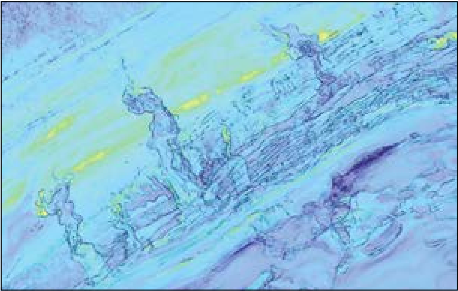
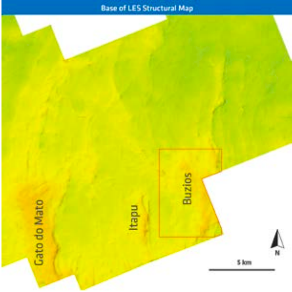
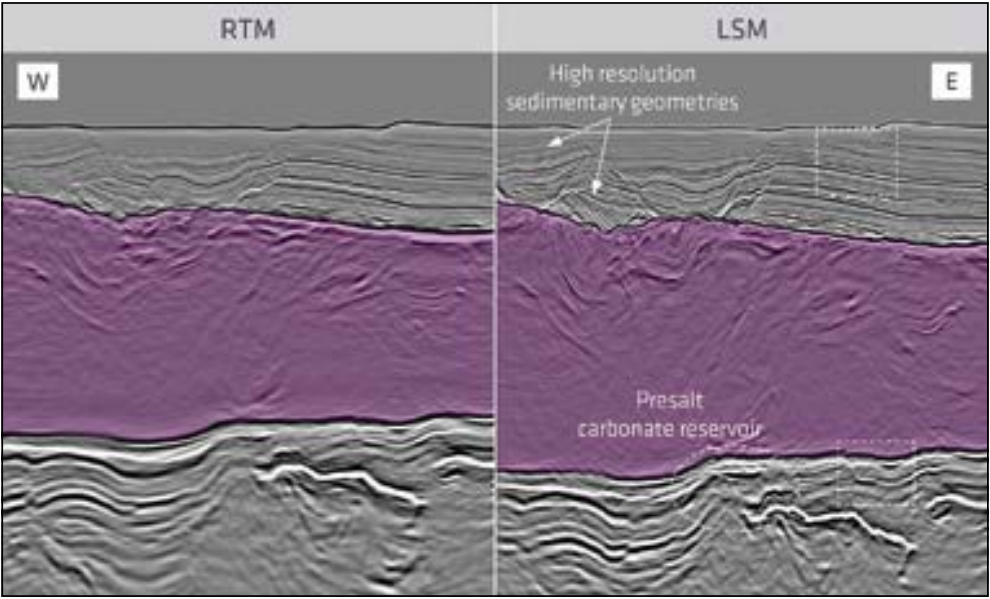
PGS has rejuvenated its Santos portfolio and final products from the reprocessing effort are available now. Covering around 34,000 km2, the Santos Vision program delivers the most comprehensive and geologically conformable dataset to date, mitigating exploration risk in the prolific pre-salt play of the basin. The latest in broadband processing has been applied and the single data volume represents the largest Reverse Time Migration (RTM) and Kirchhoff prestack depth migration (KPSDM) successfully completed by the industry. Extension of the dataset to more than 60,000 km2 of full and seamless coverage is in progress. The recent application of PGS Least-Squares Migration (LSM) to a subset of the seismic data demonstrates a further uplift in image resolution that provides unprecedented resolution in post- and pre-salt imaging. Delivering better fault definition and seismic stratigraphy for improved reservoir characterization Seismic data have many applications throughout the life cycle of hydrocarbon exploration and production. From regional reconnaissance to prospect maturation and field development, the impact of seismic data is closely linked to their quality, resolution and fidelity. These key objectives resonate throughout the energy industry, including Brazil, and demand superior seismic quality. Our answer is the deployment of innovative technologies for reprocessing existing seismic data from the Santos Basin offshore Brazil that reveals striking detail of the petroleum systems in the pre-salt and post-salt sequences of this extremely prolific basin. The Santos Vision product provides high resolution seismic images for better delineation of potential trap architectures, enhances reservoir characterization capabilities and emphasizes critical observations impacting the understanding of the petroleum system and salt displacement in the Santos Basin. The velocity model building adopts a domain approach guided by the major tectono-stratigraphic units, including the Aptian salt architecture. The focus is on a seamless geologically conformable velocity model and integrates data-driven processing results based on hyperTomo velocity updates and subsequent refinement by PGS’ unique Full Waveform Inversion (FWI) approach. Located in the Santos Basin offshore Brazil, the survey area comprises over 34,000 km2 of continuous high-resolution broadband seismic data, which have been calibrated by an increasing number of pre-salt well penetrations. The combined seismic surveys cover the São Paulo Plateau, a rift-related basement high that is subdivided into three tectono-stratigraphic domains based on the salt and post-salt architecture (Figure 1). The inboard north-western domain comprises the Albian Gap, an approximately 40 km-wide zone of Upper Cretaceous roll-over clinoforms. Its sedimentary loading displaced most of the underlying Aptian layered evaporite sequence (LES) including the post-salt Albian carbonates. The Albian Gap terminates against the Capo Frio Fault, a predominately counter-regional normal fault that reveals thick sections of Aptian LES in its footwall. The thickened salt sequence is frequently disrupted by down-building mini basins, which occasionally ground against the pre-salt sequences while carrying mega-flaps of post-salt carbonates at the base (see foldout section, left-hand side). These post-salt carbonates play a key role in creating an accurate velocity model as their interval velocities are controlled by overburden (confining pressure) and vary significantly along the Albian mega-flaps. Within the LES, highly reflective layers of evaporites indicate complex internal folding, whereas rather transparent sections are interpreted as accumulations of intra-formational mobilized halite. The occurrence of mini basins diminishes towards the south-eastern domain of the São Paulo Plateau and increasingly well imaged fold patterns within the LES can be found that are gradually transient into asymmetric and then upright folds. When approaching the most distal sections relative to the Albian Gap, little to no internal deformation is imaged in a well stratified layered evaporite sequence. The inferred original thickness of about 1,500m contrasts with the more than 4,000m thickness measured at the salt walls and diapirs separating the mini basins. It was found that displacement loading of the propagating sedimentary wedge at the Albian Gap caused lateral outward flow and frontal thickening of the layered evaporite sequence. The frontal bulging of the LES tapers out with increasing distance from the Albian Gap, as documented by the decreasing internal salt (LES) deformation towards the distal domain. In contrast to the passive behavior of the salt/LES on the São Paulo Plateau, the Merluza Graben reveals active diapirism and allochthonous salt sheets. The graben system is located inboard and separated from the São Paulo Plateau by normal faults that may exceed 3,500m in throw. It appears the faults have been active during the deposition of up to 4,500m of LES inside the half grabens, while the plateau has received merely 1,500m of evaporite deposits. The grabens reveal a north-north-east to south-south-west trend, which is also reflected by the rugose base of the LES at the São Paulo Plateau. There, the pervasive fault system forms the grain of the major pre-salt hydrocarbon reservoir facies associated with carbonate buildups that nucleate along up-thrown fault blocks. The post-salt sediment velocity model building process utilized a combination of data-driven traditional tomography and FWI. Our proprietary, unique implementation of FWI is based on the full wavefield and includes both reflection and refraction wavefields. This approach allowed iterative velocity updates of the post-salt Cenozoic sediment sequence up to 6 km depth. A geologically consistent post-salt sediment velocity model for the entire dataset was built and accurately captures the depth-dependent velocity variability of the Albian carbonates within the mega-sequences of overlying Upper Cretaceous clastic sediments (Figure 2). Following the successful results updating the velocities in the post-salt sediments, the FWI approach was extended to capture the velocity variations in the layered evaporite sequence and subsequently to update the pre-salt velocities. This data-driven approach over 34,000 km2 generated continuous velocity model updates through the salt and into the pre-salt, avoiding an imprecise horizon-based velocity boundary at the base of the salt. The resulting seismic image allows for a high resolution base of salt interpretation, as shown in Figure 3. Enhanced imaging in the Santos Basin was achieved by utilizing a full bandwidth Kirchhoff migration and a 35 Hz RTM, outputting angle gathers at every image location. Usage of angle gathers in the post-imaging workflows results in an excellent pre-salt image. Current imaging technologies (RTM, Kirchhoff Migration) provide a level of seismic resolution that suits the industry’s expectation for capturing hydrocarbon reservoirs and outlining prospects. For further improvement in resolution, PGS developed a LSM technology that corrects for acquisition effects, limited aperture and variable illumination. In this particular approach, the difference between the observed data and the synthetic data, modeled using a migrated stack and a velocity model, is minimized in a least-squares sense to update the image. The result of this application has enhanced resolution of fault patterns and sedimentary geometries in the shallow section as well as in the pre-salt section, improved imaging of the complex fold interference pattern within LES and provided a significant improvement in resolution of the carbonate reservoir section. The LSM stack also provides high granularity in attribute patterns and results in better definition of hydrocarbon reservoir targets (Figure 4). Fault patterns and stratigraphic geometries are better resolved with PGS LSM. It also provides significant uplift for prospect maturation and reservoir characterization. The enhanced seismic resolution supports mitigating compartmentalization risk, resolves depositional signatures and limits uncertainties in seismic stratigraphy characterization of reservoir facies variation. This technology proved to be beneficial at all stratigraphic levels, but most importantly in the prolific pre-salt play of the Santos Basin and elsewhere. This new regional contiguous volume accurately images the passive margin and rift section of the Santos Basin, reducing prospect risk and allowing explorationists to verify and extend their own vision of this prolific basin. The inclusion of a geologically conformable velocity model results in uplift in the pre-salt image, resolving the complexity of the layered salt and the variability of the post-salt carbonate velocities. Santos Vision delivers high granularity imaging of the base salt morphology and reveals reservoir presence. It also accurately images the faults beneath the salt, mitigating reservoir integrity risks and supporting petroleum system assessment, including gas invasion.
Santos vision: innovative seismic data processing in a super giant oil basin
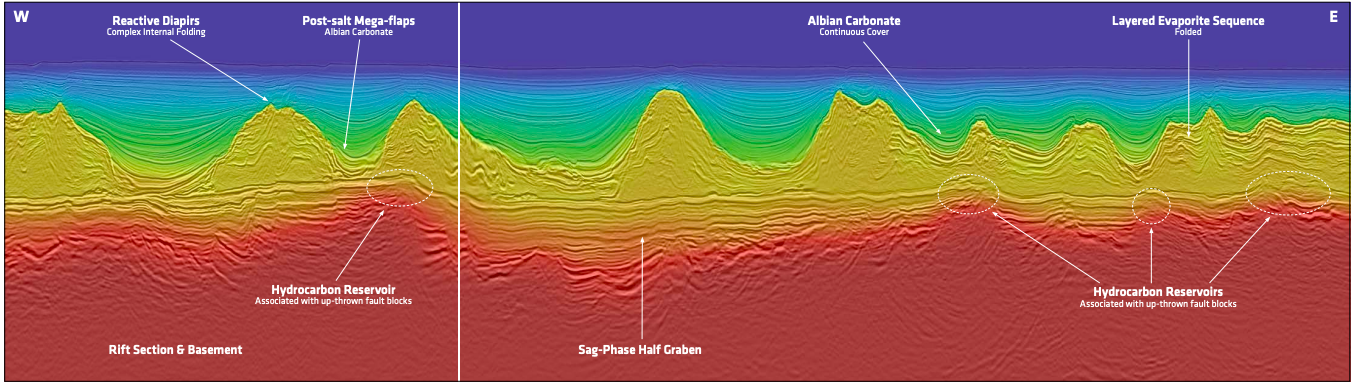 Two domains of the São Paulo Plateau are shown in the foldout seismic line. Firstly, there is the mini basin domain with thickened salt walls which separate partially grounded mini basins containing post-salt Albian carbonate mega-flaps. The second domain is characterized by harmonically folded and layered salt sequences that carry a rather undisrupted Albian carbonate cover. Potential hydrocarbon reservoirs are associated with normal fault highs of the pre-salt sequence.
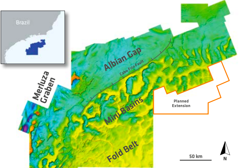
One single volume for the best geological insight of the Santos Basin
Understanding the geological setting of the São Paulo Plateau in the Santos Basin
Better seismic images
Improved definition of targets
Santos vision
Related Articles


