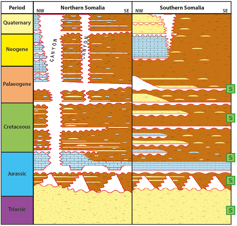
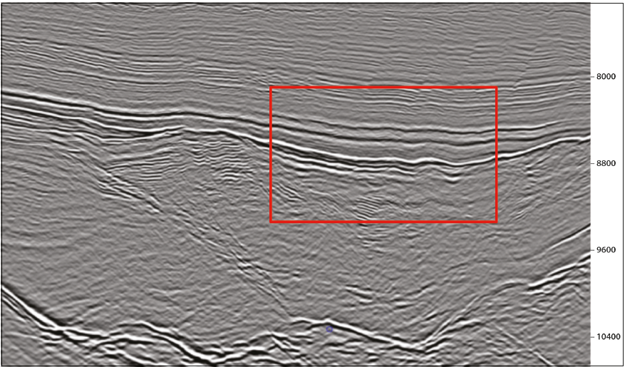
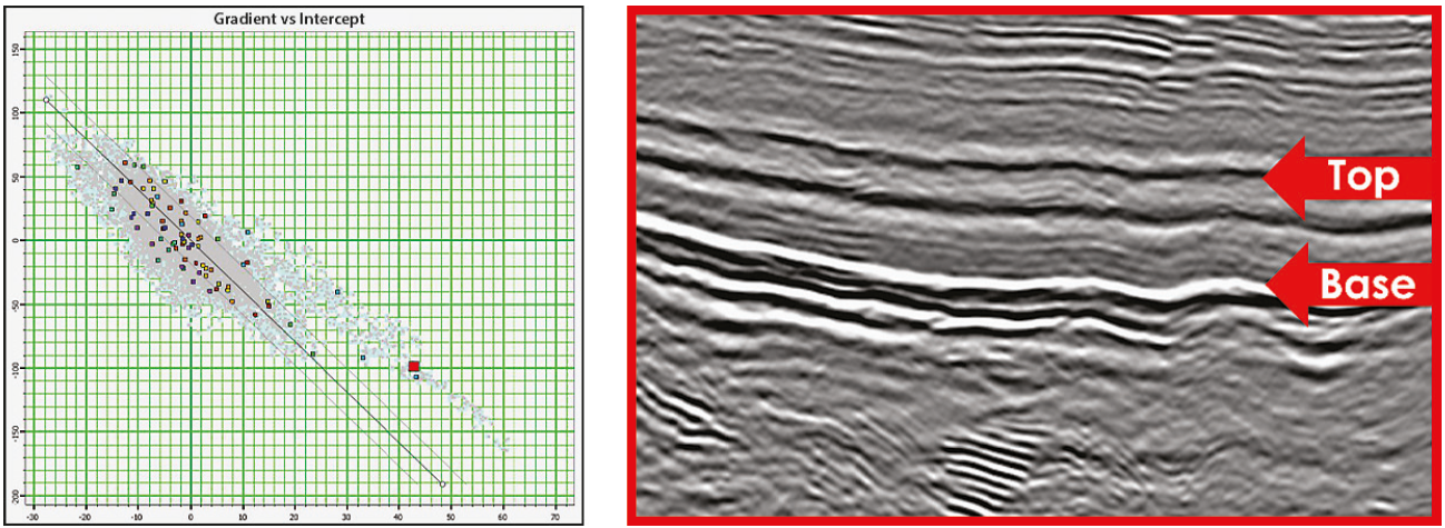
New seismic data studies from Spectrum indicate high potential for hydrocarbon exploration in offshore Somalia, with excellent opportunities on offer in the region’s 1st Licencing Round. Offshore Somalia remains one of the last truly frontier passive margins in the world, with only two exploration wells offshore along the 1,000 km-long margin. In frontier basins such as this, the first step is to identify potential source rocks by integrating multiple datasets such as gravity and magnetic data, all available and relevant well information, satellite imagery and regional knowledge, coupled with seismic interpretation. In 2015 Spectrum acquired approximately 20,000 km of long-offset 2D seismic data offshore Somalia, which has been used to de-risk source rock presence, distribution and maturity. There are strong indications of widespread distribution of good quality source rocks that modelling has shown to be in the oil window, potentially charging significant traps, making this a very attractive margin offering outstanding exploration opportunities in the 1st Licensing Round, launched in February 2019. Offshore Somalia remains one of the last truly frontier passive margins in the world. Only two exploration wells have been drilled offshore along the 1,000 km-long margin, and both are in the shallow nearshore area in less than 100m water depth. In frontier basins such as this one, the first essential step is to de-risk the presence and effectiveness (total organic carbon percentage (TOC%) and maturity) of a viable source. Identifying potential source rocks with very limited well calibration is a challenging exercise which requires integration from multiple datasets to build a robust geological model that fits with observations from seismic data. Gravity and magnetic data are used as support in the reconstruction of tectonic plate positions, conjugate margin and onshore well information are integrated, regional geological understanding and records of Ocean Anoxic Events (OAEs) are taken into account, and this is complemented with seismic observations, source rock characterisation, sequence stratigraphy models and naturally occurring slick clusters identified on satellite imagery. A regional plate tectonic and palaeo-geographic reconstruction of the margin was undertaken in order to develop an understanding of depositional and stratigraphic basin evolution. This involved identifying time periods and environments where source rock may have been deposited and preserved. The picking of ‘candidate’ source rocks on seismic data, driven by the basin evolution model, was guided in part by the observation that high TOC% oil-prone shale sources typically exhibit a low-frequency, low internal reflectivity character. Interpretation was then further constrained by criteria described by Løseth et al. (2011), which can be used to ‘identify, characterise and map spatial distributions and variations of thick source rocks’. These mainly included a significant reduction and increase in acoustic impedance (AI) at the top and base of the candidate source rock unit respectively and a reduction in amplitude with increasing reflection angle at the top of the unit. Finally, this interpretation was integrated with observations from other non-seismic direct hydrocarbon indicators, including slick clusters from satellite imagery and pockmarks from multi-beam bathymetry. All of the evidence, data and interpretation were then synthesised to provide a concise evidence base for the presence, character and potential maturity of individual ‘candidate’ sources within the offshore Somali basins. Initial Karoo rifting of Gondwana began in the Late Carboniferous/Early Permian. Deposition of the continentally-derived Karoo Supergroup, world-renowned for its source and reservoir properties, occurred across Southern and East Africa at this time. Breakup of Somalia and the Madagascar-Seychelles-India (MSI) block occurred in the Early Jurassic. This coincided with an initial marine transgression which saw lacustrine to brackish-marine restricted basin sediments deposited in rifted half grabens formed by fault block rotation. In the Middle to Late Jurassic, a restricted seaway formed between the Indian and Somali plates. Restricted marine marls were deposited in the basin at this time, while shallow water platform carbonate growth occurred on the continental shelf. From the Early Cretaceous, the northward movement of the Indian plate past the Somali plate led to the formation of large-scale transpressional and transtensional flower structures in the deep offshore, creating potentially very large trapping structures, as well as partial barriers to oceanic circulation, which may have facilitated the deposition of an organic-rich Late Cretaceous source rock. In the Late Cretaceous and Paleogene, slope failure events occurred in the southern offshore. All these observations led to the development of a stratigraphic chart for offshore northern and southern Somalia (Figure 2). Based on the detailed regional geological evaluation of the 40,000 km of 2D seismic data acquired between 2014 and 2015, several ‘candidate’ source rocks were identified by predicted depositional environment and seismic character. In the early post-rift, Upper Jurassic marine shales are a key source in the Ethiopian Ogaden Basin and in northern Somalia (Uarandab Formation). Organic-rich shales of similar age are present in the Rovuma Basin and have moderate TOCs in the Seychelles. In the deep basin, an acoustically quiet homogeneous unit was recognised at this level and was interpreted as a deep marine organic-rich marl source (Figure 3 and deep marine sapropels proposed outboard in the foldout Seismic Line). It is suggested that this candidate source rock is a regionally extensive restricted marine shale, mapped within the Obbia Basin of northern Somalia. No well control or oil discovery exists to date to confirm the presence or test the maturity of the interpreted source horizons. In order to provide additional evidence for the presence of a hydrocarbon-producing source the low-frequency character present at the inferred source interval on the seismic section was further supported by a significant decrease in acoustic impedance at the top of the infererred source rock unit and a dimming of amplitude with increasing angle (AVO Type IV) (Figure 4). Additionally a sea-surface slick study was employed which identified more than 80 individual non-anthropogenic sea surface slicks along the length of offshore Somalia. Basin modelling considering four potential source rock intervals was carried out in collaboration with Leeds University. Peak maturation maps for source rocks at pre-rift (Karoo), syn-rift, Late Jurassic and Early Cretaceous levels indicate that where the sediment column is thickest in the south, shallower Early Cretaceous sources are in the oil window. Where the pre-rift, syn-rift and early post-rift is not so deeply buried in the north, these source intervals sit in the present-day oil window. Defining source rocks in untested frontier margins can present a challenge; however, by integrating multiple datasets and geological models developed from seismic analysis, gravity and magnetic data, offset well information, satellite slick mapping and sequence stratigraphy models, we can propose various scenarios in which organic-rich sediments may have been deposited. This method combined with basin modelling has highlighted particular areas of interest for lead and prospect identification at multiple stratigraphic levels offshore Somalia. In modern seismic data offshore Somalia we have now found the illusive oil-prone gem in East Africa’s otherwise prolific petroleum systems. Source rock presence, distribution and maturity are largely de-risked for oil plays. The attraction of large oil reserves will draw the attention of the oil industry to Somalia in 2019, as this new province has now opened up its offshore waters for exploration in its exciting and hugely prospective 2019 licensing round.
The chase for oil in offshore Somalia
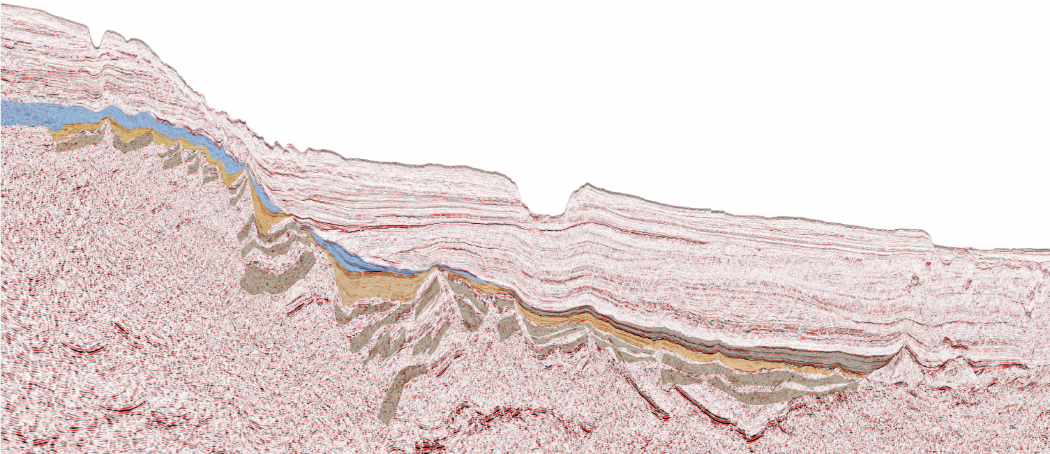 190 km-long Spectrum PSDM seismic section with brown tones highlighting the main pre-rift, syn-rift and early post-rfit inferred source rock intervals.
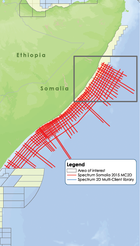
The illusive oil-prone region of offshore Somalia
Source rock evaluation
Seeking potential source rocks
Exciting upcoming licensing round offshore Somalia
Related Articles


