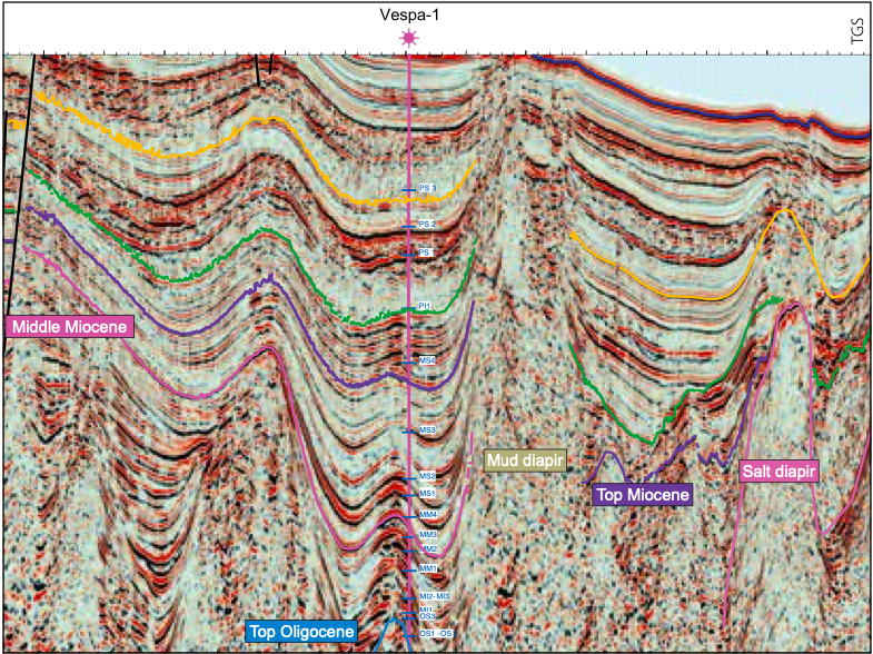
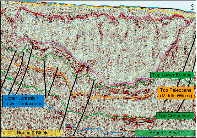
TGS’ Gigante is the largest 2D multi-client seismic survey in the world. It comprises 186,250 km of long offset data (streamer length 12 km, record length 16 sec) spanning the entire Mexican Gulf of Mexico (GOM), and ties to datasets in the US GOM. An additional 5,700 km covers the unexplored Caribbean coast of the Yucatan Peninsula. Gigante provides continuous coverage across the entire GOM, linking known petroleum systems to vast underexplored areas of the basin as a springboard for new exploration. The Gigante seismic survey is complemented by potential field data and over 600,000 km2 of multibeam data with coring and geochemical analysis. This provides the industry with a comprehensive database with which to evaluate the petroleum systems of the entire GOM. TGS’ interpretation study utilizes all available datasets and aims to deliver a complete regional tectono-stratigraphic interpretation of the Mexican offshore. A complex tectonic history has resulted in numerous structural provinces throughout the Mexican New seismic data has revealed a wealth of untested opportunities in the Mexican offshore. The geological evolution of the Gulf of Mexico (GOM) began with Late Triassic rifting followed by Late Jurassic oceanic spreading and then transition to a passive margin. Thick Middle Jurassic salt deposited in rift basins began to move by the Late Jurassic. A stable tectonic setting developed from the Late Jurassic, characterized by carbonate deposition on shallow water structural highs fringing the subsiding oceanic basin. Large Late Cretaceous to Miocene clastic sediment inputs related to events like the Laramide and Chiapas orogenies resulted in gravity sliding and high amplitude fold belts along the western flanks of the basin. Complex contractional terrains in the southern GOM are overprinted by halokinesis, which also sets up deepwater play possibilities in the Salina del Istmo. The Gigante regional survey is ideally suited to creating a catalog of structural styles, depositional characteristics, and trap and play types for each of the Mexican GOM (MGOM) structural provinces. Seismic integration with potential field data helps constrain the tectono-stratigraphic framework and provides insights to deep structure and the extent of oceanic – continental crust boundaries. Several major structurally defined provinces are defined in the MGOM (see map, above). Sedimentary basins immediately offshore the eastern and southern coasts of Mexico are dominated by belts of extensional normal faults, ranging in age from Triassic – Jurassic syn-rift faults to listric normal growth faults of Tertiary to Recent age. Fold belts lie outboard of the extensional belts, and may be linked to them by detachment surfaces in overpressured shales or may be distal expressions of onshore orogenies. Major salt provinces in the Salina del Bravo and in the Salina del Istmo form the outermost structural provinces before we pass into the Abyssal Plain. Industry interest is currently focused on these basins following the recent announcement of the CNH R02-L04/2017 bid round. The Yucatan Platform, with no fringing extensional or contractional belts, forms a distinct area whose major structural influence was the Chicxulub impact which resulted in breccia deposits and fracturing of Mesozoic carbonates. Combination and stratigraphic traps may be more important than structural traps in the Yucatan Platform and in parts of the Yucatan Escarpment. The Salina del Bravo province lies between the offshore Burgos Delta (characterized by extensional fault block geometries) and the Perdido Fold Belt and has transitional boundaries with them. It has two sub-zones: a western mini-basins zone and an eastern sub-salt zone. The listric normal growth faults seen in the adjacent Burgos Delta detach into Eocene to Oligocene shales. A range of structural styles, controlled by mobile salt and by salt- and shale tectonics, reflects regional shortening of the thin-skinned gravity-driven linked extensional-contractional system that extends from the Burgos Basin to the Perdido Fold Belt. The main structural features developed in the Salina del Bravo area are salt (and/or mud) diapirs and walls. Onlap-type traps with updip pinchout against salt are common. Anticlinal structures (whether turtles or salt-cored folds) are also likely trap types. An example is shown in Figure 1. Figure 2 shows an undrilled anticlinal closure in Paleocene – Eocene Wilcox sands in the sub-salt zone. The cross-border Perdido Fold Belt is bounded by the Salina del Bravo to the west and the Abyssal Plain to the east. The north-east to south-west trending anticlines were developed during Oligocene contraction, as evidenced by the prominently developed Late Oligocene unconformity characteristic of the fold belt and the fact that the Lower Miocene, Oligocene and Eocene strata are often missing at the crests of anticlines (e.g. at Trion-1). The development of the Perdido Fold Belt is still contentious; however, most interpretations are some variant on detachment folds (possibly salt-cored) associated with steep reverse faults or kink bands. In the south, offshore the Tampico-Misantla Basin and the Tuxpan Platform, the passive continental margin is characterized by a series of normal growth faults known as the Quetzalcoatl Extensional System (QES). The QES is a zone of listric normal growth faults linked downdip through detachment surfaces in overpressured shales with an approximately 500 km long downdip series of long and narrow coast-paralleling anticlines (the Mexican Ridges) along the continental shelf and slope (Figure 3). Trap types in the QES are rotated fault blocks and rollover anticlines. Fields in the QES include Lankahuasa and Kosni. No fields have yet been developed in the Mexican Ridges (MR) which are high amplitude, low half-wavelength folds that have been building since the Oligocene. The MR folds range up to 170 km long and 8 km in width and are often prominently developed at seabed. The Catemaco Fold Belt (CFB) lies between the Mexican Ridges and the Salina del Istmo provinces. The CFB is characterized by north-east to south-west aligned anticlines, thrust faults and fault-bend folds which were created during Late Miocene-Pleistocene contraction due to the interplay of the Chiapaneco orogenic event and gravitational contraction of the Mexican Ridges. Several of these folds have yielded gas discoveries. Unlike the MR, the Catemaco Fold Belt anticlines (other than the Yoka Anticline at the edge of the salt) have little to no expression at sea floor. The offshore Salina del Istmo/ Campeche Salt Basin is bounded to the west by the Catemaco Fold Belt, to the east by the Yucatan Platform and to the south by the Sureste Basins (not discussed here). To the north it passes into the Abyssal Plain, where stretched continental/transitional crust passes into oceanic crust. Above the basement, Pre-Triassic red beds and Early to Middle Jurassic syn-rift sediments are overlain by Callovian salt and Late Jurassic to Recent post-rift clastics and carbonates (as seen in the seismic panel, above). Salt motion, active since the Late Jurassic, allied with major structural events such as Late Miocene folding and Pliocene-Pleistocene gravitational extension, has resulted in a wide range of proven structural and combination traps in this province, such as those recently tested by Sierra (Zama-1) and ENI (Amoca-2). The syn-rift extensional traps featured in the seismic panel in this article remain an untested opportunity in the deep offshore Salina del Istmo.
Regional play types in the Mexican offshore
Gulf of Mexico, each with characteristic structural styles and sedimentary sequences. This article presents an introductory discussion on the structural styles and play types that are witnessed in the seismic data and provide insights on each geological basin. View of the northern Salina del Istmo, at the foot of the Campeche Escarpment, showing a thick pre-salt syn-rift section overlain by salt and rotated fault blocks of Upper Jurassic – Early Cretaceous sequences.
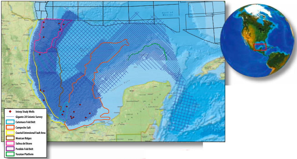
Structural styles and regional play types
Salina del Bravo
Perdido Fold Belt
Quetzalcoatl extensional system and the Mexican Ridges

Catemaco Fold Belt
Salina del Istmo/Campeche Salt Basin
Related Articles


