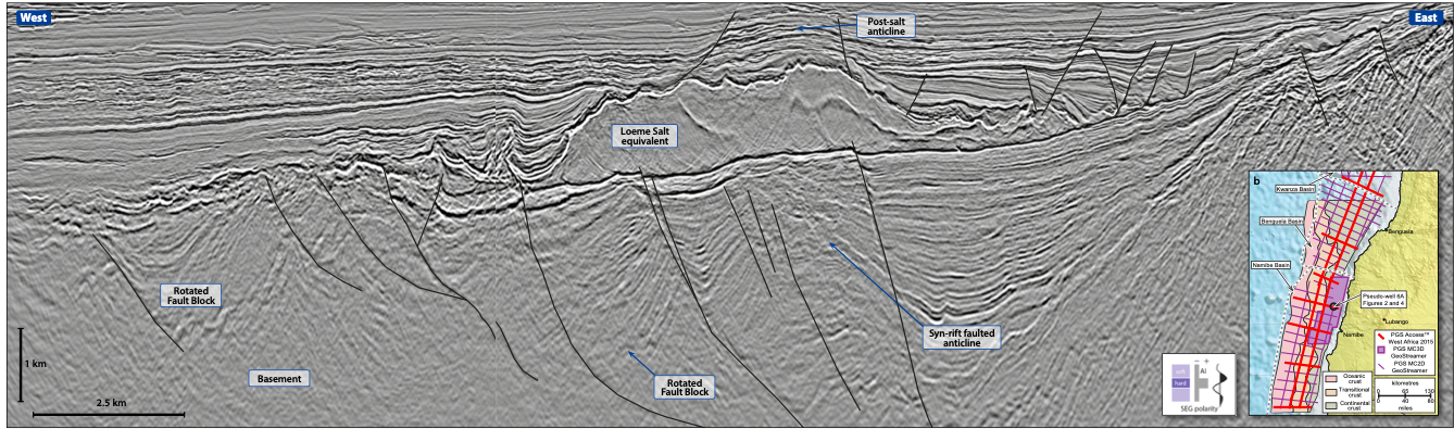
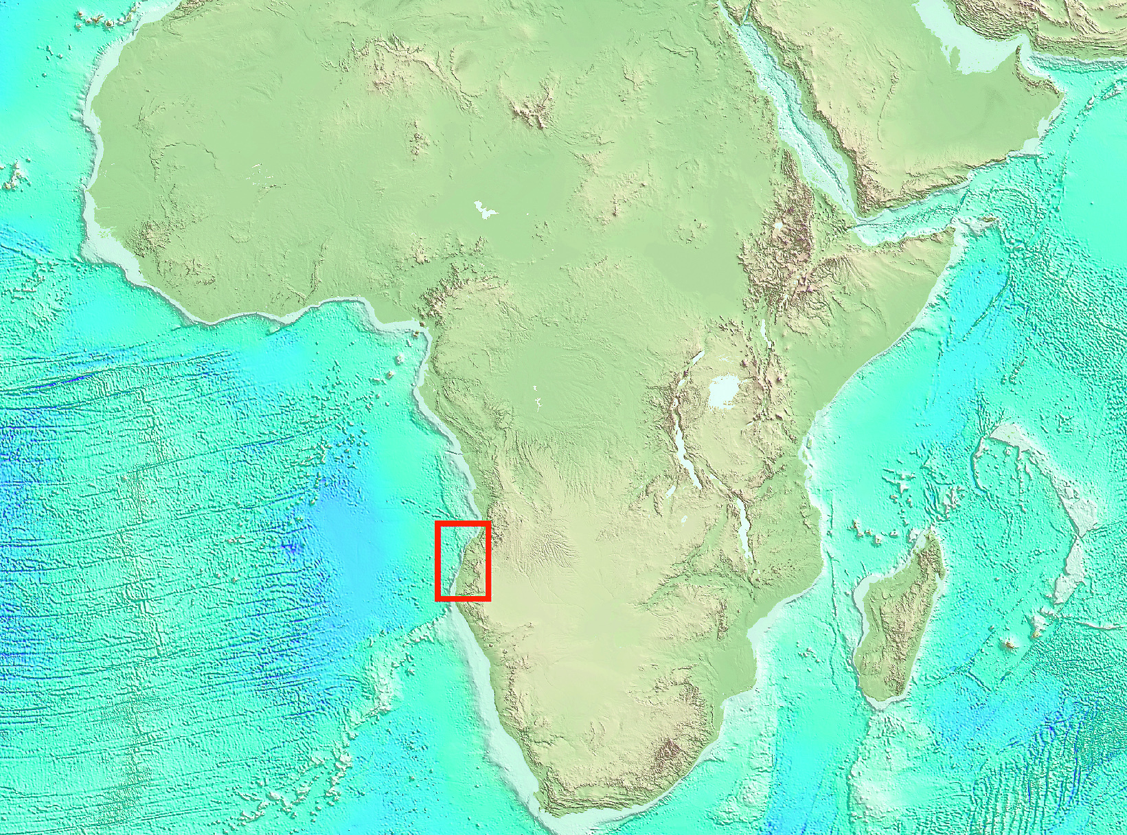
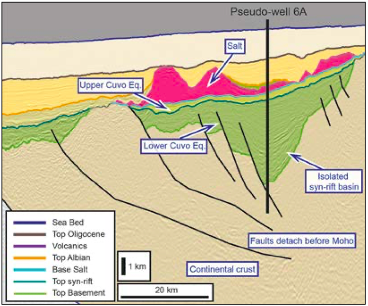
Unlocking an Angolan Frontier With renewed anticipation of a licence round offering open acreage across large prospective blocks, is it now time to explore this attractive region? PGS dual-sensor broadband GeoStreamerTM data has identified significant syn- and post-rift potential in the Namibe Basin. This article aims to use the superior imaging offered by GeoStreamer to present an interpretation of the tectono-stratigraphic elements and prospectivity of the Namibe Basin, a frontier region with no wells. It furthermore seeks to address some of the challenges that have occurred in analogous hydrocarbon provinces such as the neighbouring Kwanza Basin, offshore Angola. The section below identifies some of the key features and structures that have been revealed by GeoStreamer data in the Namibe Basin. Compelling seismic evidence for a significant unexploited hydrocarbon province located offshore southern Angola. The Namibe Basin represents a significant unexploited hydrocarbon province located offshore southern Angola (Figure 1). During the Late Jurassic–Early Cretaceous the eastern Atlantic margin of this part of West Africa developed as the conjugate margin to the prolific hydrocarbon-bearing Santos and Campos Basins. Although recent research describes the conjugate margins of Kwanza/Campos and Namibe/Santos as asymmetrical (Unternehr et al., 2010) with each basin containing slightly different petroleum elements, discoveries of supergiant oil fields such as Lula in the Santos Basin and Linguado in the Campos Basin have meant previously overlooked pre-salt targets of the eastern Atlantic margin have been re-assessed (Koch et al., 2013). The resulting exploration of the eastern Atlantic margin has been rapid with significant discoveries made in neighbouring Angolan basins, such as Ombovo in Kwanza and Hivoua in Congo. The acquisition of several recent 2D and 3D dual-sensor broadband GeoStreamer surveys by PGS (Figure 1) provides a unique opportunity to unravel and de-risk the complex structural and stratigraphic history of the Angolan margin. As no wells have been drilled in the Namibe Basin, stratigraphy is mainly inferred from the analogous Kwanza Basin. Source rocks for the Namibe Basin are expected to occur predominantly in the syn-rift and sag phase sections with secondary early post-rift sources. Regional heat flows from Angola and Namibia show a range of 24–68mW/m2 (IGI, Integrated Geochemical Interpretation, 2015). Using an average regional heat flow of 47mW/m2 (Figure 2) the syn-rift source rock equivalents of the Upper Cuvo (Bucomazi Formation) and Lower Cuvo lacustrine shales show a variable maturation with the Lower Cuvo Formation, reaching early gas/ condensate maturity in the lower interval and oil maturity in the upper interval. The Bucomazi Formation is oil mature when modelled as a high sulphur kerogen type. Other source rocks may exist in the form of sag phase equivalents to the Upper Cuvo Formation (Chela Member) transgressive shallow marine clastics/carbonate marls, and post-rift Pinda Formation equivalent deep marine shales. Modelling of hydrocarbon maturation and expulsion suggests that the Lower Cuvo Formation would have begun to expel oil from the early Eocene. The base of the Bucomazi Formation as shown in Figure 2 is expected to have barely expelled hydrocarbons since the Quaternary. The transformation ratio through time implies that all hydrocarbons would have been generated at the base of the Lower Cuvo Formation and that generation would have occurred by varying amounts throughout the entire formation. The interpretation of 2D and 3D GeoStreamer data has allowed for seismic facies to be delineated and analogues to be drawn from similar seismic facies observed in the Kwanza Basin. Syn-rift reservoirs are therefore likely to exist as formation equivalents to the Lower Cuvo Formation deep marine sandstones, Upper Cuvo Formation fluvial to lagoonal facies and carbonates of the Bucomazi Formation. Post-rift reservoirs are expected to be comprised of shallow marine sandstones of the Iabe Formation, the Pinda Formation (Binga Member) carbonates, and deep marine sandstones of the Landana Formation. The presence of the Loeme Salt is well known in the Kwanza Basin, where it acts as the main seal for fields such as Orca/Baleia. Seismic imaging and interpretation has shown that the Loeme Salt equivalent is more extensive in the Namibe Basin than previously identified in conjugate margin reconstructions (Torsvik et al., 2009). Syn-rift seal in the Namibe Basin is therefore likely to be provided by the evaporites of the Aptian Loeme Salt Formation equivalent (Figures 3 and 4). Where salt is absent, intra-formational marine shales of the Bucomazi, Pinda, Iabe and Landana formations would likely represent alternative seals. The Namibe GeoStreamer seismic data show multiple trap types present in the syn-rift and sag phase as well as the post-rift sections (Figures 3 and 4 and main seismic panel, above). Syn-rift and sag phase traps include tilted fault blocks with potential stacked reservoirs in the Lower Cuvo equivalent; carbonate build-up associated with the sag phase (Figure 3); four-way dip closures; and syn-rift stratigraphic pinch-outs of the Lower Cuvo equivalent. There are also multiple trap types in the post-rift, which are more commonly associated with halokinesis and include post-salt anticlinal closures, stacked channel complexes, and stratigraphic pinch-out traps (see Figure 4 and the main seismic panel, above). Recent exploration wells in the southern Kwanza Basin have encountered high concentrations of CO2 in pre-salt reservoirs which have been geochemically typed to mantle melts that are interpreted to have displaced an earlier oil charge (Bump et al., 2016). The presence of >20% CO2 in hydrocarbon reservoirs is rare (Santos Neto et al., 2012) and geographically unpredictable, often with CO2 wells being adjacent to successful exploration wells (Bump et al., 2016). An initial study of the Namibe Basin has been undertaken as part of the PGS Access™ West Africa 2015 report, in which Bouguer gravity data and magnetic survey data combined with 2D GeoStreamer data have identified a transitional zone (Figure 1) where gravity modelling suggests localised areas of raised Moho or exhumed mantle. Using PGS MC2D GeoStreamer data, a number of syn-rift basins have been identified which are isolated from such areas of raised Moho/exhumed mantle. Mantle derived CO2 may either be sourced via deep-seated faults penetrating the Moho or through shallow exhumed mantle degassing. Interpretation of the PGS GeoStreamer data shows these syn-rift basins to be isolated from exhumed mantle by basement highs (e.g. Figure 4) and with faults which detach prior to the Mohorovicic discontinuity, suggesting a lower risk for CO2 contamination in these areas. PGS dual-sensor broadband GeoStreamer data help to identify significant syn- and post-rift potential in the Namibe Basin. Open acreage and an anticipated licence round make the Namibe Basin highly attractive for frontier exploration. Potential leads have been identifed throughout the Namibe Basin including stacked carbonate and clastic reservoirs in the syn-rift and sag phase, large 4-way dip closures and multiple syn- and post-rift stratigraphic traps. Potential oil prone sources are likely to be provided by equivalents to the syn-rift Lower Cuvo lacustrine shales, sag phase Upper Cuvo Formation and post-rift Pinda Formation deep marine shales. Basin modelling suggests that complete generation and expulsion of hydrocarbons will have occurred for the Lower Cuvo Formation with partial expulsion from shallower sources. Seismic imaging and interpretation have shown the Loeme Salt equivalent to be the most likely seal as it is more extensive than previously identified in conjugate margin reconstructions. With no well data available in the Namibe Basin, the MultiClient MC2D and MC3D PGS GeoStreamer data, combined with gravity and magnetics, provides the perfect platform to de-risk and unlock the prospectivity of the frontier Namibe Basin.
The Namibe Basin: a clearer Image
The Namibe Basin
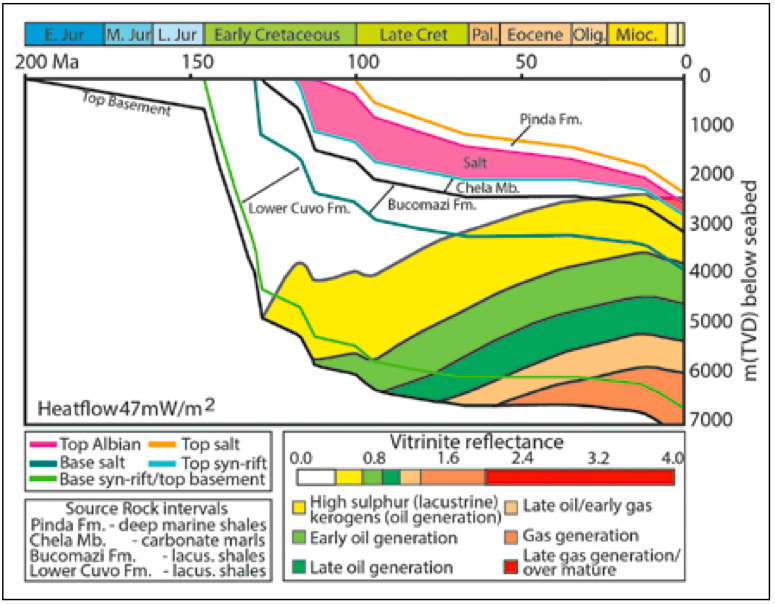
Source potential
Reservoirs and seals
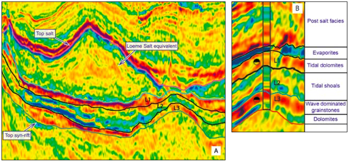
Traps and structures
Challenges of CO2 contamination
Significant potential
Related Articles