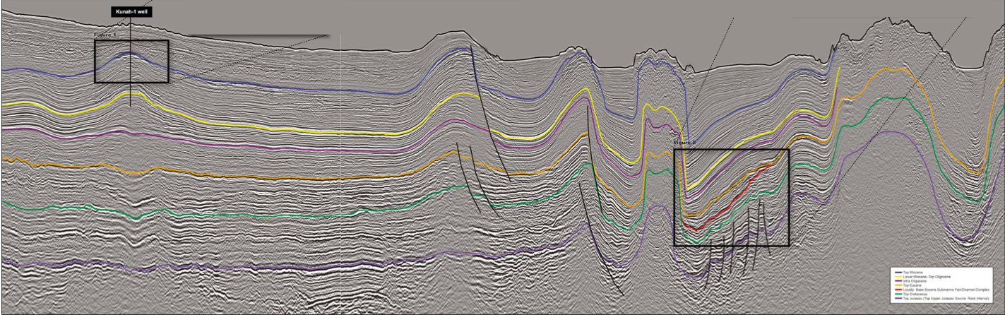
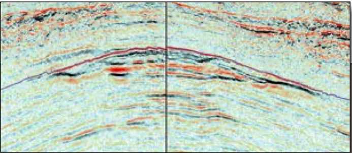
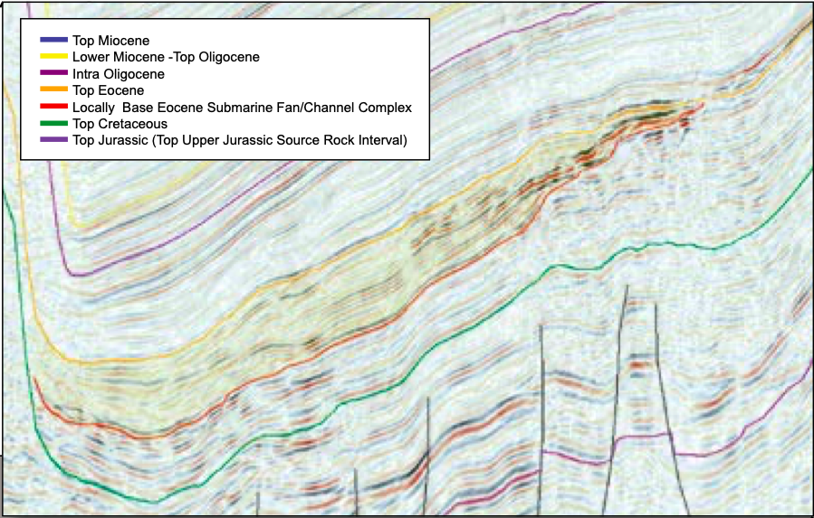
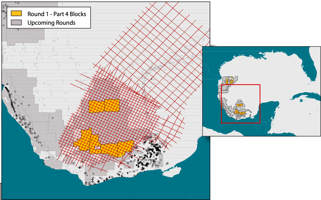
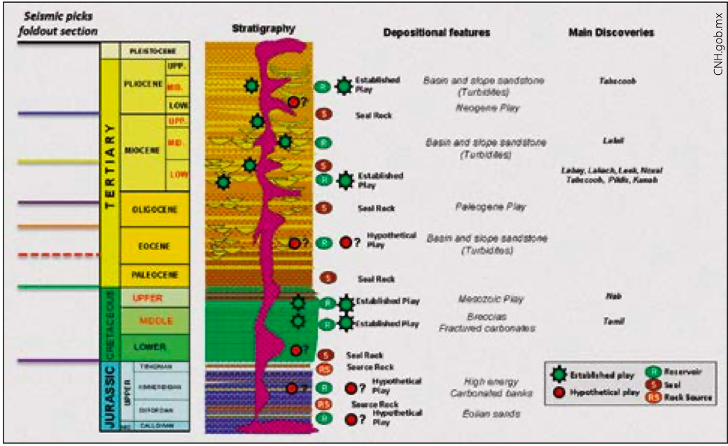
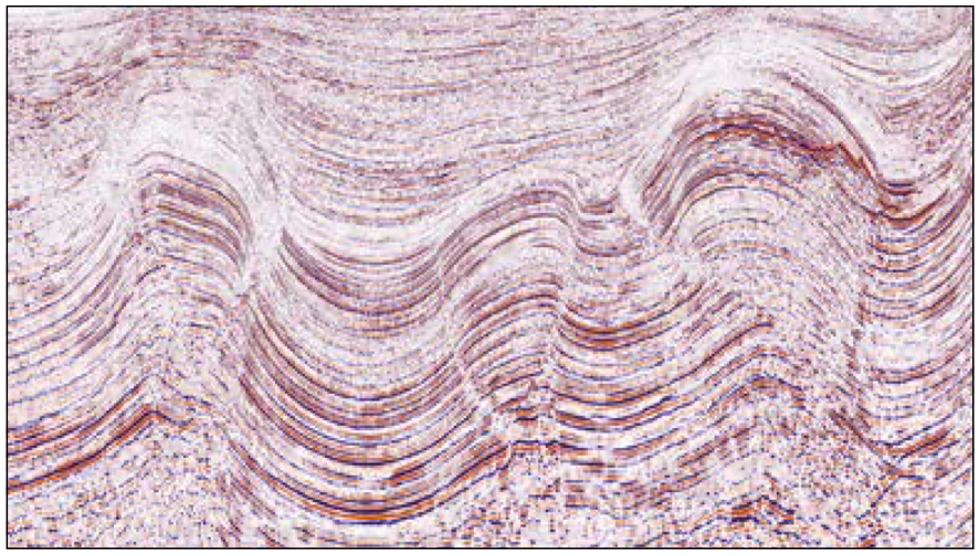
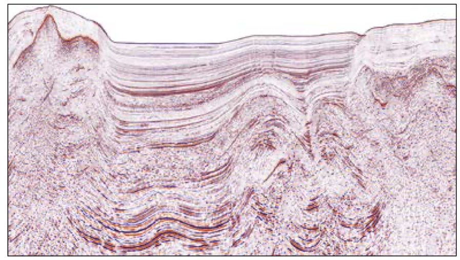
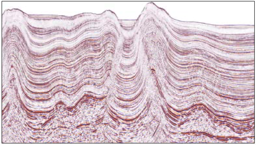
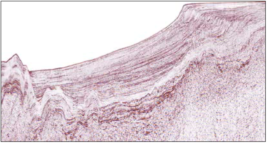
New long-offset seismic data provides a closer look at the structure and petroleum potential of the Campeche Basin offshore Mexico. The Campeche Basin holds tremendous hydrocarbon potential with several proven commercial oil and gas fields (see Vast Potential: Mexico’s Offshore Ronda Uno). The first bid round in the Campeche deepwater salt basin is underway. Mexico has a long and colorful history of oil and gas exploration that started at the end of the 19th century. Between 1868 and 1938 there was active exploration by foreign oil companies. In 1938, a decree was made that the oil and gas resource in Mexico belonged to the state and soon thereafter Pemex was formed as the National Oil Company. However, in 2013 Mexico opened up for outside exploration investment after decades of monopoly on producing, refining and selling oil and gas in the country. Pemex has now been privatized and foreign exploration companies are invited to explore for oil and gas both offshore and onshore Mexico. A new Petroleum Agency, the CNH (Comisión Nacional de Hidrocarburos), has been formed to regulate these new activities. In 2015 the CNH developed a five-year plan for bid rounds, which is considered an excellent opportunity in the exploration community, despite the current low oil price. Several international oil companies see these Mexican bid rounds as some of the best investment opportunities in the world. In anticipation of the bid round plan, MultiClient Geophysical (MCG) acquired a long-offset grid of high resolution 2D seismic together with gravity and magnetic data, called the Maximus Survey, over the Campeche Basin and the Yucatan Platform (see Location Map above). The Maximus MC2D dataset has recently been completed. The survey was acquired using very long offsets and deep records in an attempt to provide exploration companies with a complete profile of the sedimentary section. Processing is using a broadband solution. Both pre-stack time migrations and pre-stack depth migrations are being produced using a detailed velocity grid. The Maximus survey is an excellent dataset to use when carrying out regional play fairway analysis and to high-grade prospective exploration areas. The survey has clear imaging and broad coverage of the regional structure and stratigraphy of all play elements (source rocks, reservoirs and seals) in the region, which are shown in Figure 3. The seismic line shown in the foldout (main panel seismic panel, above) is located close to the western edge of the deepwater salt basin. The dominant trapping configurations are salt-related anticlinal and flank structures to the salt domes and walls. The top of the Upper Jurassic source rocks is easy to map throughout the whole survey area where thick allochthonous salt is not present. Key surfaces representing reservoir and seal bearing intervals within the Cretaceous to Tertiary levels are also consistent and present within large parts of the survey area. The complex salt-cored foldbelt in the middle of the basin presents some imaging challenges in the time domain. However, these challenges are being addressed through the pre-stack depth migration processing. This survey is an excellent dataset for reducing risks of prospects as illustrated in distinct imaging of Direct Hydrocarbon Indicators (DHIs, flatspots and amplitude anomalies). Two interesting examples of prospective trends are shown on the foldout. The drilled gas discovery Kunah-1 (Figure 1) shows two pronounced flatspots, where the shallower one proved to be gas/water contact while the deeper was a remnant from an earlier hydrocarbon contact. This is also consistent with EM anomalies presented by Pemex at the EM conference in Oslo, May 2013. The Eocene turbidites in Figure 2 show clear imaging of stratigraphic trapping possibilities and the strong, up-dip amplitudes that may indicate hydrocarbon presence within a Lower Tertiary submarine fan in open bidding blocks. The relationship between the interpreted seismic horizons and the stratigraphy and play elements are shown in detail in Figure 3. Four proven and three possible plays are shown in the stratigraphic column. In the deepwater salt basin, it is understood that only two wells deeper than 1,500m have been drilled. This region is highly folded and very complex, with many large structures and deep basins, as shown in Figures 4, 5 and 6. These structures are large and some are active at the present time. Many of the structures are cored by allochthonous Callovian-age salt. In the north of the Yucatan Peninsula, the salt is more autochthonous and thinner than in the core part of the basin west and north-west of the Peninsula. An example of this is shown in Figure 6. Potential play fairways on and near the Yucatan Peninsula shelf edge, near the Cantarell field, have the same rationale as the proven commercial play in the Cantarell reservoir rock, which was formed by the impact of the Chicxulub meteorite on the Yucatan Platform. The reservoir rock for the Cantarell field is a brecciated carbonate that was part of the debris created by this meteorite 66 million years ago. One target for exploration companies is to understand the distribution and depositional conditions that make this breccia a commercial reservoir rock. Figure 7 shows the connection of the Yucatan Peninsula and the equivalent deepwater section located roughly the same distance from the impact site as the Cantarell field. There is much information available from the CNH on the bid round blocks, as well as data packages and Pemex 3D seismic data available for purchase. Pemex was an active company in this basin for some time with good success, including the giant Cantarell field and associated plays. Exploration companies will be able to generate more exploration success in the upcoming bid rounds by using new data to develop new, fresh ideas for the region. New regional long-offset seismic datasets will play a key role in this effort. The Maximus seismic survey was developed for this purpose.
World Class Exploration Opportunities in Deepwater Mexico
New dataset reveals plays
Salt-related structures
Cantarell-type plays
from the Chicxulub Meteorite impact site.Related Articles