Quantifying Reservoir Performance for Deepwater Slope Channel Deposits
Turbidite slope channel deposits pose many challenges during exploration and development planning. Spectacular exposures in southern Chile provide useful insights in predicting sandstone distribution and connectivity in these complex reservoirs.
From the Gulf of Mexico, south to the Campos Basin off the coast of Brazil and across the South Atlantic to the petroleum basins of offshore Angola, deepwater slope channel petroleum reservoirs are important targets in today’s exploration environment. Exploitation of these deposits are high reward, but also high risk, with little room for errors. Reservoir performance is impacted by the different reservoir facies, varied channel stacking patterns, and the effect of low flow barriers within these reservoirs. Our ability to capture that impact through reservoir modeling is critical to efficient well designs and development plans.
Ongoing outcrop-based study of middle to lower slope strata of the Tres Pasos Formation in the Magallanes Basin of Chilean Patagonia is providing critical insights into the evolution of channelized deepwater slope systems and analog data for subsurface characterization of complex reservoir architectures. As part of this effort, bed-scale geocellular models are being produced to look at the influence of sub-seismic scale reservoir architecture on reservoir performance and prediction. These models evaluate the impact of geologic parameters such as facies distributions, channel-stacking patterns, and variations in internal channel architecture, as well as the effects of reservoir model cell sizes or upscaling. Their findings will help refine future reservoir modeling and development strategies.
Gaining a Better Understanding
“Geologic heterogeneity, though complex, is not random,” says Casey Meirovitz (Department of Geology and Geophysics, University of Utah in Salt Lake City, Utah), a doctoral student working with Dr. Lisa Stright of Colorado State University (CSU, Fort Collins, Colorado) and the Chile Slope Systems Joint Industry Project (JIP). “Geologic architecture that we observe at outcrop contains a record of multiple depositional processes. By understanding the depositional processes which create the observed variability in architecture, and the preservation of sediments, we become more predictive in creating geologic models of the subsurface where data are more limited.
“Sub-seismic scale heterogeneity in channelized deepwater reservoirs can lead to significant uncertainty in reservoir connectivity and predicted performance,” Casey continues. “Oil companies actively working in deepwater channelized reservoir systems have struggled to accurately predict reservoir volumes and therefore wrestle with optimal well placement. With these wells costing in excess of $200 million, a better understanding of these depositional systems is urgently needed.”
The Chile Slope Systems JIP was formed to study a unique set of deepwater outcrops located in the Magallanes Basin of Chilean Patagonia. This project is a collaboration between the University of Calgary, Colorado State University, Virginia Tech, University of Utah, and their industrial partners. Continued orogenesis of the Andean fold thrust belt exposes the fill of the Magallanes Basin, revealing nearly continuous down-deposition-dip panels for about 100 km. According to Dr. Stright, “The high quality of outcrops placed in the context of position along the slope profile and slope evolution makes the Ultima Esperanza District worthy of the attention of the oil and gas industry, which is exploring channelized systems in the deeper waters off of continental margins around the world.”
Student Adam Nielson (CSU at Fort Collins, Colorado) stands on the contact between the underlying ‘Mistral Channel’ and overlying ‘Blue Channel’ in the Upper Laguna Figueroa channel complex, Laguna Figueroa locality. Labels indicate depositional facies associations. Inset: Interbedded sand and shale typical of the off-axis and marginal depofacies, can strongly influence intra-channel connectivity and, ultimately, reservoir performance. (Source: Casey Meirovitz)
Predicting Reservoir Performance
“Within the oil industry, reservoir model cell sizes and resolution of available data do not typically allow for the direct representation of internal channel architecture,” says Casey. “In this study, I have tried to find out if the internal architecture really mattered in reservoir modeling. If it does, when is it important and what is the amount of error that could be introduced by not representing it?”
Casey set up a case that closely mimics the bed-scale architecture, which we will call a realistic condition, using a high-resolution outcrop-based geocellular model; a random condition that preserves the facies proportions of the realistic condition but distributes them randomly throughout the channel body; and finally a homogenous condition using a uniform flow-averaged permeability. The homogeneous case was an attempt to create the type of data that would be available in an exploratory field study. Reservoir simulations are performed using a single injector-producer pair completed in an off-axis position at the opposing margins of the channel. Simulations were run for each of the fill scenarios.
“We initially ran simulations on the simplest case, a single channel element,” says Casey. “We found that both the random and homogenous cases overpredict total oil production by ~10% with a delayed water breakthrough when compared to the ‘actual’ condition. This was primarily due to both the random and homogenous cases over-predicting the sweep of the marginal facies.”
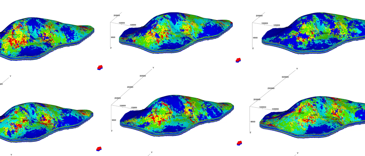
Model of the channel complexes in the Upper Cretaceous Tres Pasos Formation within the Laguna Figueroa Outcrop Belt. (Source: Casey Meirovitz)
Detail of the model of the channel complexes in the Upper Cretaceous Tres Pasos Formation, viewed from the north east. (Source: Casey Meirovitz)
Adding Complexity
“To test the influence of stacking patterns on reservoir performance,” says Casey, ‘we took two channel segments with identical internal architectures defined by the realistic conditions. We held one channel stationary and a second channel was rotated around it at different angles and offset distances. We used a single injector-producer pair as was used in the single channel simulations. The injector and producer have been placed diagonally in opposing margins of the two channel segments, forcing flow to travel between the two segments.”
What they found is that recovery efficiency is highest for laterally offset channel segments and decreases to its lowest when channel segments were stacked vertically on top of each other. In the vertically stacked channels, a fast flow path is created along the axis (a thief zone created by sand on top of sand), leaving oil in the marginal, siltier facies. When water is forced to travel through the marginal facies of laterally offset channels, recovery increases, albeit the time to recover the same amount of oil is prolonged.
“We expected, and confirmed in the simulations, that while recovery efficiency is higher from the laterally stacked channels, the rate of oil production is much lower than that of the vertically stacked channels,” says Casey. “While out of the scope of this investigation, this does ask the economic question ‘is it better to get more oil at slower rates than to get less oil overall but sooner in the project?’’’
Oil recovery is highest in laterally stacked channels where the marginal facies buffers intra-channel flow, resulting in increased sweep of the margins. Where channels stack vertically, a preferential flow path forms through the inter-connected channel axes, leading to only partial sweep of the marginal facies. Each channel element is 14 m thick and 300 m wide. A reservoir is generally comprised of multiple stacked channels. (Source: Casey Meirovitz)
Scaling
“We have been dealing with a very fine-scaled, high resolution representation of internal channel architecture in our simulation runs,” says Casey. “These fine scales used thus far are not feasible to produce large field-scale simulations. We upscaled from the original geologic detail to quantify the error introduced by different cell sizes used in the models and to identify an optimal cell size. Cell grids ranged from 2m x 2m x 0.25m up to 50m x 50m x 2m.”
Once again, they used a single, realistic case type channel and ran production simulations at different scales. They repeated the simulations with two channel stacking patterns, ranging from lateral to vertical, using 12 different offset models. The margin of error in oil recovery over the fine-grid ‘actual’ condition induced from upscaling was greater in laterally offset channels than in the vertically stacked channels. Upscaling was not able to capture the fine-scaled heterogeneity of the marginal facies and thus overestimates oil recovery. They found that cell sizes up to 25m x 25m x 1m captured fairly accurate oil recovery estimates when compared to fine-grid realistic cases. It should be pointed out that these cell sizes are still well below what is used for a full-field simulation. Additional studies are needed to build coarse-scale models that can mimic bed-scale controls on flow.
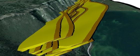
Laguna Figueroa Outcrop Belt
(Source: Casey Meirovitz)
The study area is located around 45 km from Puerto Natales (situated on the Seno Última Esperanza, ‘Last Hope Sound’) on Ruta 9 Norte and lies within the Torres del Paine National Park in southern Chilean Patagonia (see map above for location).
The cross section opposite shows the general stratigraphic scheme for the study area.
Two channel complexes, each over 100m thick, have been delineated in the Upper Cretaceous Tres Pasos Formation in the Laguna Figueroa area.
The Tres Pasos Formation consists of a turbidite-dominated slope system that records the terminal phase of deepwater deposition in the Magallanes foreland basin, southern Chile.
This channel complex, pictured below, is comparable in scale to systems that have been explored in the subsurface in petroleum basins off numerous continental margins around the world.
More information on the program can be found at http://chileslopesystems.com
Upper Cretaceous Tres Pasos Formation. (Source: Casey Meirovitz)
Expanding the Study
The Tres Pasos outcrop belt within the Magallanes Basin spans approximately 100 km and covers over 1,200m of vertical stratigraphic thickness. Individual outcrops are many kilometers long and 100s of meters thick, representing seismic scale outcrops. “What makes them most useful is that we are able to characterize sub-seismic scale internal architecture and trends within the context of the larger seismic-scale slope-channel architecture,” says Casey. “These outcrops capture channelized deepwater deposition for the basin floor up the middle and lower slope all the way to the genetically linked deltas on a scale comparable to similar subsurface features off Brazil, west Africa, the Gulf of Mexico, and other important petroleum basins of the world.
“This study was focused on a set of channels on the slope. However, architectures vary along the slope, and from clinoform to clinoform, and continued studies of this unique area will help us predict reservoir performance as a function of location along the slope.”
Casey goes on to say that, “All of our simulations, including upscaled models, reveal the critical role of the marginal facies on the movement both within and from channel to channel. In doing this work, we hope to quantify the influence of inter- and intra-channel heterogeneity on reservoir performance, and ultimately produce results which will aid industry professionals in producing predictive models and optimized production strategies for channelized deepwater reservoirs.”
Acknowledgments
Special thanks to Casey Meirovitz and Dr. Lisa Stright for the information and edits.
More information on the program can be found at http://chileslopesystems.com
Further reading from the GEO ExPro Archive
Torres del Paine – The Patagonian Diamond by Olivier Galland and Caroline Sassier
Southern Chile’s Ring of Fire by Olivier Galland, University of Oslo, and Caroline Sassier
Kota Kinabalu, Sabah: A Turbidite Paradise by Rasoul Sorkhabi, Ph.D
Advertisement