Augmenting Seismic in Challenging Resource-Rich Areas
Just as 3D seismic improved oil and gas exploration, new technology is helping identify oil and gas resources in high definition in areas of permafrost, volcanic cover and heavy oil.
New to the web!
This article first appeared in our iPad edition No 4 (2013) and is now made available via our website for the first time.
Planning a drill program on inaccurate information is an expensive risk every exploration team should avoid. But seismic can be baffled as resource exploration edges into more challenging environments like Africa and the Arctic, and in areas of permafrost, volcanic cover and heavy oil, where seismic can deliver incomplete results or be cost-prohibitive.
Anyone can turn 2D data into a 3D image. But the information that makes up the image will be far from 100% accurate. A new technology that aims to offer more complete and accurate interpretation for instances where seismic results are inconclusive is ORION 3D, developed after years of proprietary technology work by the internal Research and Development department at Quantec Geoscience, together with a team of internationally experienced geophysicists. And there’s even more good news: this technique has an almost negligible environmental footprint.
Reducing Exploration Risk
ORION 3D’s data is in higher resolution because greater density of data is collected.
An ORION 3D survey is set up differently to comparable geophysical survey systems, allowing it to acquire more (True 3D) data over multiple, intersecting lines, across a larger area, in higher resolution.
Three sets of data are collected: DC (resistivity), IP (chargeability) and MT (deep resistivity). After analysing the high volume of subsurface data collected, this information is then used to identify size, extent or volume, shape, position and depth of resource-rich geological units. The high number of acquired channels, which are set up along a series of intersecting orthogonal lines, offers more sensitivity control. When such a wealth of information is collected, only high quality data are included in the inversion process, enabling a more reliable interpretation.
It would appear that this system is unique in its ability to rapidly and simultaneously gather True 3D data. In addition, this can easily be integrated with other data sets, like seismic.
Volcanic Cover and Permafrost to Challenge Seismic
Where volcanic layers are present, seismic signals and data quality can be significantly degraded, as volcanic material is often very irregular and complex. This complexity reduces the quality of seismic data and interpretation, or even prevents its acquisition. Seismic energy is absorbed and scattered by these volcanic layers, decreasing the ability to image beneath them. As a consequence, drilling results suffer from inaccurate seismic interpretations.
Imaging through volcanics – side view.
Imaging through volcanics – top view.
Permafrost layers affect seismic surveys in much the same way. They are highly variable in thickness and extent, and absorb and scatter seismic energy. The cold climate, coupled with environmental restrictions, also create large areas where seismic cannot acquire data effectively in the Arctic.
However, because ORION 3D measures geological resistivity, it is not affected by permafrost and basalt. The system uses high impedance electrodes, designed for good contact on challenging ground such as snow-covered and permafrost environments. The electrical signals can easily penetrate the frozen crust of permafrost and uneven layers of basalt to identify the geological layers of interest below.
Quantec’s research team has developed several innovative methods in order to survey in extremely resistive geology with near-zero environmental impact by, for instance, using environmentally responsible receiver technology that does not require the toxic chemicals used in other receivers.
The technology is also lightweight; it can explore sensitive areas and avoid leaving a significant environmental footprint. The highly flexible 3D ground geophysical survey can mobilise anywhere and is effective in all terrains, conditions and climates, from 40 degrees above celsius to 40 degrees below.
Challenges in Heavy Oil Recovery
Heavy oil recovery relies on Steam Assisted Gravity Drainage (SAGD) where the reservoir is capped by a layer of impermeable rock. Because drilling is an expensive way to identify thief zones (formations into which circulating fluids can be lost), results from an ORION 3D survey can be used to identify the structural deformations that influence the shape of the resource, which means that exploration and extraction wells can be planned to avoid drilling into an area where the resource has pinched out.
Check before you drill: resistivity surveys can help locate thief zones within a reservoir.
In SAGD, the bitumen is extracted by injecting steam into the reservoir through one horizontal well, and extracting the melted bitumen through another well, replacing the extracted bitumen with water. One major challenge, however, is mapping zones where bitumen has been extracted. Seismic images have difficulty showing where the bitumen is located as opposed to where the water has replaced it, as the density of oil and water are too similar for seismic to distinguish.
Resistivity surveys can map these changes with ease because of the large resistivity contrast between bitumen and water. The DC and MT measurements create a snapshot of the earth’s resistivity, so a resistive area, such as oil or bitumen, is imaged as separate to a more conductive area, like water. True 3D resistivity measurements add definition to seismic interpretation to more accurately define the zones of water and bitumen within the reservoir. ORION 3D not only makes it easier to recover the bitumen, but also to manage the reservoir on an ongoing basis.
Quantec Geoscience can also run Time Lapse Monitoring of resistivity patterns and create 4D differencing models. In 4D SAGD monitoring, the same survey is done in the same location to see changes to the resource before, during, and after extraction in order to optimise well placement and identify length of extraction time.
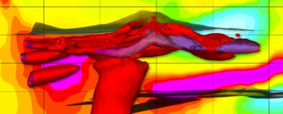
4D Difference models increase resource recovery by tracking how the reservoir changes over time.
Find New Targets
In addition to augmenting inconclusive seismic results, an ORION 3D survey can also be used to find new targets. The omni-directional data collection method is capable of pointing out new parts of the resource other exploration methods may have missed. As a result, exploration teams will be able to inexpensively define drill targets, confidently create a more reliable drill program, and better manage resources over time.
Conductive Zones.
3D sections showing target zone allow an exploration team to know how far back the resource extends instead of just how deep.
Every aspect of the ORION 3D ground geophysical survey is designed to inexpensively augment seismic to provide a complete, more accurate picture and detailed subsurface information. Quantec believe that the technology offers the first ground-based, environmentally low impact survey capable of collecting and presenting 3D chargeability and resistivity data. This will allow exploration companies to avoid early uncertainties, improve drill results, maximise recovery and better manage drill budgets in even the most challenging terrains, climates, and conditions.
Video: Slicing through the data to reveal a 3D geobody.
Further Information
You can find out more about Quantec Geoscience by visiting their website here – LINK