On Shaky Ground Induced Earthquakes
Over the last decade, certain oil and gas producing areas have come alive, experiencing an escalating number of felt earthquakes, some even large enough to cause property damage.
Most people consider California an area likely to be hit by frequent, and sometimes damaging, earthquakes. After all, the state lies within and along a tectonically active plate boundary where elastic strain energy accumulates in the Earth’s crust and can be suddenly released, causing earthquakes. Move into the mid-continent area of the United States, far from the natural stresses of a boundary between moving continental plates, and, historically, earthquake activity has been considerably less.
House damage in central Oklahoma from the M5.6 earthquake on November 6, 2011. Research conducted by USGS geophysicist Elizabeth Cochran and her university-based colleagues suggests that this earthquake was induced by injection into a deep disposal well in the Wilzetta North field. (Source: Brian Sherrod, USGS)
In Oklahoma, for example, before 2000 on average one and a half earthquakes of magnitude 3 (M3) or greater occurred each year. In 2013, the Oklahoma Geological Survey (OGS) observed two >M3 earthquakes each week and by early 2015, they reported that an average of two and a half >M3 or greater earthquakes were occurring each day. In April, 2015 an OGS Statement on Oklahoma Seismicity by Richard D. Andrews, State Geologist and Dr. Austin Holland, then State Seismologist, now with the USGS, stated that, “The OGS considers it very likely that the majority of recent earthquakes, particularly those in central and north-central Oklahoma, are triggered by the injection of produced water in disposal wells.”
Out of hundreds of thousands of energy developments in the US, only a small fraction of those have caused detectable seismic activity noticeable to the public. Of the suspected induced seismic events, very few have been large enough to cause property damage. However, the increase in the seismic hazard associated with oil and gas activities both in North America and Europe has been attracting the attention of politicians, the public, the industry, and scientists seeking to understand the causes and solutions to mitigate the consequences.
Measuring the Seismic Hazard
Most of the Earth’s destructive natural earthquakes occur at or near convergent and transform plate boundaries along areas of active deformation. Earthquakes also happen along divergent plate boundaries and are generally associated with shallow earthquake activity from extensional forces stretching the lithosphere. Under the low temperature and pressure conditions of the upper lithosphere, silicate rock can build up huge amounts of elastic strain energy. The sudden release of this stored energy occurs through the rapid sliding of faults, causing earthquakes at a wide range of magnitudes. The released energy travels through the crust as waves of elastic energy, also called seismic waves, that can be measured and felt on the surface as earthquakes.
Because shear stress levels across continental plates are near the strength limit of the crust, there is also a potential for natural earthquakes to occur in interior continental areas far away from active deformation zones. As Dr. William Ellsworth, Professor at Stanford University in California, who has divided the central and eastern US into two equal sized areas, points out: “Most of the earthquakes for this large area have occurred along ancient basement faults at rates much lower than areas along the plate boundaries. Over most of the central and eastern US, the US Geological Survey (USGS) earthquake hazard model is derived by projecting the spatially smoothed historical earthquake rate, with aftershocks removed, forward in time. Therefore, these two areas should have a constant rate of earthquake occurrence. However, parts of the western area have experienced an upsurge in seismicity levels since 2000 that continues to increase.”
2014 National Seismic Hazard Map for the US (not including Hawaii and Alaska) showing areas in red and orange as having the highest seismic risks (10% probability of exceedance in 50 years of peak ground acceleration). Notice the areas of suspected nontectonic (human-caused) earthquakes and compare this to the next map.
Graph and position of earthquakes which have occurred since 1973. Notice the increasing number of earthquakes since 2009, particularly the post-2009 earthquakes (red dots) in the south-western portion of the map in Oklahoma and Texas.
Looking to the Cause
“The cause of the recent observed changes in seismicity in parts of Oklahoma, Texas, and Colorado has become a rather contentious question in some circles,” says Dr. Ellsworth. “There is always room for more research and better data, but an extensive and solid body of scientific investigations, theory, and even experiments document how earthquakes can be induced”.
In fact, human-initiated earthquakes have been documented for over 100 years. Recognized causes include huge hydroelectric projects with large water reservoirs, mining activities, geothermal drilling, nuclear detonations, and extraction and injection of fluids and gas into subsurface formations.
One of the first links to induced earthquakes caused by underground wastewater storage was made at the Rocky Mountain Arsenal (RMA) near Denver, Colorado. A deep injection well was drilled in 1961 to dispose of hazardous chemicals stored at the facility. Several months after fluid injection started, earthquakes were felt and measured in the north-east Denver area. Before injection ceased in February, 1966, thirteen M4 or larger earthquakes were recorded. The three largest, including an M4.8 event in 1967 that caused minor damage, were logged after injection had stopped. Hydrologic modeling showed the migrating seismicity was tracking a critical pressure front. Although declining, seismicity continued occurring for 20 years up to 16 km from the injection site.
Another important step in understanding how fluid injection, and thus fluid pressure in a fault, could control earthquake activity occurred at the Chevron-operated Rangely oil field in north-western Colorado (see Teamwork at Rangely). Studies on the earthquakes at the RMA led scientists to believe that earthquakes could be controlled by modulating the fluid pressure in a fault. In 1969, the USGS conducted an experiment to test this theory. Chevron allowed the USGS to regulate the fluid pressure in a portion of the Rangely field that was known to be seismically active. After two cycles of fluid injection and withdrawal they found that the rate of seismicity could be controlled by adjusting the pore pressure at the depth where the earthquakes initiate.
Schematics (not to scale) of two mechanisms for inducing earthquakes related to oil and gas operations. An increase in the pore pressure along a fault is illustrated on the left, while the right side shows how load changes on the fault (either through extraction or injection) can induce movement. (Source: Dr. Ellsworth, USGS and Science)
An Excess of Earthquakes
The four areas in the central US that have seen more than their share of earthquakes in recent years are the Raton Basin on the Colorado-New Mexico border; through central Oklahoma; in the Dallas-Fort Worth, Texas area; and at the Cogdell oil field in western Texas. “These areas have been thoroughly investigated using available seismicity, well, and geologic data,” says Dr. Ellsworth. “In most cases, the evidence points to wastewater disposal by injection as the cause.” He cites at least eight recent papers covering this subject.
“These areas do not contain the extensive knowledge of the stress, pore pressure, and hydrologic conditions that made the Rangely experiments possible,” Dr. Ellsworth adds. “Consequently, the studies rely on spatial and temporal correlations when assessing the involvement of industrial activity as the cause of the increased seismic activity, which leaves speculation about other possible causes.” (Note that in most states, the industry currently holds the proprietary data on underground conditions, subsurface geology and fault locations which would allow a more rigorous scientific analysis such as was conducted at the Rangely field in Colorado.)
As other causes, Dr. Ellsworth cites hydraulic fracturing treatments, which have induced M4 earthquakes in Canada. No evidence has been found to support hypotheses such as the effects of the severe drought in Texas and Oklahoma or a natural tectonic event. Most of these other theories have been discounted. The 2015 OGS Statement of Oklahoma Seismicity says: “The primary suspected source of triggered seismicity is not from hydraulic fracturing, but from the injection/disposal of water associated with oil and gas production.” They found that the earthquakes occur over a very large area, about 15% of the state, corresponding to a region “that has experienced significant increase in wastewater disposal volumes over the last several years.”
Another interesting finding regarding the Oklahoma earthquakes is that most occur within crystalline basement well below most oil and gas operations. The OGS attributes this to reactivation of the basement faults from water injection and that the pressure from the water disposal sites can be transmitted several kilometers from the injection site.
It should be noted that only a small fraction of the over 35,000 active wastewater disposal wells, 80,000 active enhanced oil-recovery wells, and tens of thousands of wells hydraulically fractured every year in the US have caused any increase in detectable seismic activity. For example, research by Dr Cliff Frohlich and others at the Institute for Geophysics and Bureau of Economic Geology (BEG), the University of Texas at Austin, shows that the Williston Basin, with the rapid Bakken development and greatly increased injection volumes since 2007, has resulted in no observable increase in earthquake activity. Generally, most of the induced earthquakes are small; only the 2011 M5.6 Prague, Oklahoma earthquake resulted in significant losses ($10 million insured). Two other earthquakes recorded in 2011, at Trinidad, Colorado and near Guy- Greenbrier, Arkansas, caused minor property damage.
USGS Addresses Induced Hazards
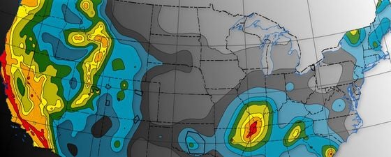
The US Geological Survey (USGS) has just released the first one-year seismic hazard forecast for 2016 that includes the potential for both induced and natural earthquakes in the Central and Eastern United States. Past seismic hazard models, including the 2014 United States National Seismic Hazard Model, had nontectonic events, such as those caused by wastewater injection or other human activities, removed from consideration for their hazard assessment. Their objective was to provide forecasts of locations, magnitudes, and rates of future natural earthquakes as well as estimates of long-term shaking hazard that are applied in building codes and other public policy applications. Therefore, induced earthquakes are not considered in the current building-code maps but do create a seismic hazard to structures in a very populated portion of the central US and other areas where they occur. This new forecast map shows that the chance for damage in north-central Oklahoma and southern-most Kansas is similar to that of high-hazard sites in California.
See, Induced Earthquake Hazards Finally Addressed, for a more detailed discussion on this map.
Chance of damage bassed on the average of horizontal spectral response acceleration for 1.0-second perios and peak ground acceleration.
The Next Step
A new study by the USGS (see map illustrated above) shows some areas in the US have up to a 1:8 chance of experiencing damaging ground motion within a single year, comparable to high hazard areas of California. To this end, government officials have taken note in preparing for this increase in seismicity and are starting to fund further studies.
The State of Oklahoma is now in the process of improving their earthquake monitoring, adding staff and working closely with the USGS and other researchers worldwide investigating induced seismicity. In his role as the State Geologist of Texas, Dr. Scott Tinker worked with State of Texas legislators, agency heads, industry and academics to establish the $4.47 million TexNet facility, which is managed by the BEG. TexNet will install 22 permanent and 36 portable seismometers around the state. The Center for Integrated Seismicity (CISR), comprising over 20 scientists and engineers and led by Dr. Peter Hennings and Dr. Ellen Rathje, is an academic-government-industry consortium established by the Bureau to work with TexNet data and conduct integrated seismologic-geologic-engineering research. Stanford University has its Center for Induced and Triggered Seismicity, in which Dr. Ellsworth and nine other professors are involved, addressing a wide variety of scientific and operational issues associated with managing the risk posed by induced and triggered earthquakes. Let’s not forget the researchers at the USGS, through their Earthquake Hazards Program, who have been at the forefront of monitoring and assessing earthquake impacts and hazards, and continue their research into the causes and effects of both natural and induced earthquakes. The recent release of ‘2016 One-Year Seismic Hazard Forecast for the Central and Eastern United States from Induced and Natural Earthquakes’ is already making an impact.
This awareness and new research is not just happening in the US. The Netherlands, for example, has been experiencing shaking from the long term production of gas from the Groningen field. The Dutch Petroleum Company (NAM) and the government are working closely to manage the hazard.
USGS geophysicist and Director of the Induced Seismicity Project, Dr. Art McGarr, states that, “In contrast to natural earthquake hazard, over which humans have no control, the hazard from induced seismicity can be reduced. Improved seismic networks and public access to fluid injection data will allow us to detect induced earthquake problems at an early stage, when seismic events are typically very small, so as to avoid larger and potentially more damaging earthquakes later on.”
Stanford Center for Induced and Triggered Seismicity
(Source: William Ellsworth)
Dr. William Ellsworth is currently a professor at Stanford University where he co-directs the Stanford Center for Induced and Triggered Seismicity.
Before joining Stanford, he was a research geophysicist at the USGS for over 40 years and served as Chief Scientist of the Earthquake Hazards Team.
Dr. Ellsworth is co-author of the ‘2016 one-year seismic hazard forecast for the Central and Eastern United States from induced and natural earthquakes’ by Mark D. Petersen, Charles S. Mueller, Morgan P. Moschetti, Susan M. Hoover, Andrea L. Llenos, William L. Ellsworth, Andrew J. Michael, Justin L. Rubinstein, Arthur F. McGarr, and Kenneth S. Rukstales (Open-File Report 2016-1035).
To find out more visit the USGS website – Link
Further Reading
Induced Earthquake Hazards Finally Addressed by Thomas Smith
Teamwork at Rangely by Thomas Smith
The author would like to offer special thanks to Dr. Michael L. Blanpied, USGS for his review and suggestions.


