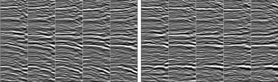
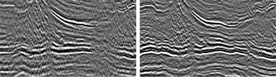
Renewed interest in Africa’s largest oil producer. The Niger Delta is one of the most prolific hydrocarbon-producing basins in the world and huge discoveries in the late 1990s and early 2000s established the deepwater delta as a worldclass petroleum province. Renewed focus in the deepwater areas over the past 12 months underscores the significant importance of the western Niger Delta for oil companies. Slip evolution and gravity driven extension across the western Niger Delta has led to the development of complex, large fold and thrust belts and to a diversity of structures including toe-thrust anticlines, listric and transcurrent faults, shale diapirs and mud volcanos. The complexity of the deepwater fold and thrust belts necessitates high quality 3D seismic data. Simple time processing cannot solve the imaging issues in this diverse and structurally complex province. A pre-stack depth migration trial (PSDM) performed for Polarcus by DownUnder GeoSolutions delivers a significant uplift in image quality, which will facilitate improved interpretation and assist in the understanding and analysis of new and untested plays. The Niger Delta is one of the most prolific petroleum provinces in the world, covering an area of over 300,000 km2 with a sedimentary succession over 12,000m thick in the main depocentre. Oil companies have been exploring the area since 1936 and have drilled more than 8,000 wells since first oil was discovered by Shell Darcy at Oloibiri creek, in 1956. The Niger Delta developed at the site of a rift triple junction related to the opening of the southern Atlantic. The delta grew in a series of pulses of sedimentation over an oceanward-dipping continental basement onshore with possible rift sequences offshore, and then by progradation over a landward-dipping oceanic basement in the deepest water areas. The overall regressive, offlapping sequence is composed of three diachronous siliciclastic units: the deep-marine pro-delta Akata Group, the shallow-marine delta-front Agbada Group and the fluvial Benin Group. The primary source rocks in the Niger Delta are the marine shales of the upper Akata Formation, whilst the interbedded marine shales of the lowermost Agbada Formation provide a secondary source. In shelfal and onshore areas the primary reservoirs are sandstone facies within the Agbada Formation, whilst the turbidite sands of the upper Akata Formation provide a primary target in both deepwater plays and frontier deep plays in nearshore and onshore areas. In many places channel morphology also changes rapidly from sinuous to relatively straight, with reservoir facies deposited both within channel axes and as lobes, in part determined by gravity sliding over overpressured marine shales. The delta has prograded towards the south-west from Eocene to Recent and is transected by several northeast-southwest fracture zones. It appears to be a primarily extensional province in shelfal areas, but has predominantly contraction dominated toe-thrust systems in the deepwater areas. The syn-depositional collapse of the clastic wedge complicates stratigraphic correlation and modelling in many areas, whilst detachment in the deep seated over-pressured Akata Formation has resulted in the penecontemporaneous development of toe-thrust anticlines, listric and transcurrent faults, shale diapirs and mud volcanos. The main structural trap types in the deepwater fold belts tend to be shear fault-bend folds and detachment anticlines within the Akata Formation. During the 1990s a myth developed that the deepwater Niger Delta appeared problematic in terms of structuration for holding hydrocarbons and the farther and deeper you went beyond 1,600m water depth, the less likely you were to find significant hydrocarbons. The reality was that at the diverse and complex structural styles entrenched within the region created imaging issues that could not be solved with the simple time processing of the available seismic data at the time. In addition to which formation pore pressures greater than regional overpressure, local stresses and fractures could lead to seal breach and failed traps . Chevron discovered the first commercial offshore field (Okan) in 1963, but compared to other West African Tertiary basins, Nigeria’s deepwater areas remain comparatively underexplored with fewer than 10% of the country’s exploration wells drilled in water depths of over 200m. The Department of Petroleum Resources of Nigeria (DPR) has granted Polarcus Nigeria Limited, a joint venture between Polarcus and Ashbert Limited, exclusive rights to broker 10,800 sq. km of modern high quality 3D seismic data covering large tracts of the prospective western deepwater area. Only five exploration wells have been drilled in the project areas to date, even though the world-class Bosi (ExxonMobil, 1996), Erha (ExxonMobil, 1996), Bonga Southwest (Shell, 2001) and Uge (Chevron, 2006) deepwater discoveries lie in adjacent blocks. The brokered 3D surveys were acquired between 1999 and 2004, and have been processed through a comprehensive de-multiple and Pre-Stack Time Migration sequence. Whilst the existing 3D multi-client data is largely of good quality, the complex geology of this area creates imaging issues which cannot be solved with simple time processing. To demonstrate the uplift in image quality that is possible in this area, a 3D pre-stack depth migration reprocessing trial has been initiated by Polarcus. A test line through the 2003 vintage NG03 3D dataset has been reprocessed by DownUnder GeoSolutions from field tapes through to Kirchhoff depth migration, using high-resolution reflection tomography to iteratively build the velocity model as part of the workflow. Comprehensive pre-processing was performed prior to velocity model building; three de-noise steps including 3D true-azimuth SRME and high resolution Radon de-multiple were utilised. Reflection tomography was then used to iteratively build the velocity model. The model was checked at each iteration and updated when and where necessary. The data were migrated using a true relative amplitude Kirchhoff pre-stack depth migration with the Green’s functions determined by dynamic ray tracing – the rays are traced through a gridded velocity model with maximum energy rays chosen. Testing was performed to ensure that the sampling was sufficient to capture all frequencies unaliased, with variable depth sampling output from the migration. There were no assumptions made about lateral or vertical velocity variations, apart from the model being smooth. Work is not yet completed, but a significant uplift in image quality has already been achieved by DownUnder GeoSolutions using a state of the art pre-stack depth migration workflow, with further improvements expected. Structural elements such as faults are more clearly defined. Illumination issues near faults have now been resolved. Better event continuity and obvious resolution improvements are also clear – as can be seen in the full stack and image gather comparisons above. A more accurate structural picture at the target level can now be interpreted as a result of the improved velocity model and depth imaging. The deepwater gravity-driven fold-belt structures are fundamentally different from onshore orogenic fold-belts and exploration success in the offshore fold-belt areas will depend on understanding their architecture. The results of the depth migration trial have shown a significant improvement in data quality, which will facilitate improved structural interpretation, section reconstruction, seismic stratigraphy and facies analyses and will further assist in the identification and analysis of untested plays. Subject to industry underwriting interest Polarcus is planning to expand the depth processing across the whole project area, and is also planning to acquire new 3D surveys in Q1 2015. Bird, D., Shear margins: Continent-ocean transform and fracture zone boundaries. The Leading Edge. (Feb. 2001). Kostenko, O. V., Naruk, S. J., Hack, W., Poupon, M., Meyer, H-J., Mora-Glukstad, M., Anowai, C., Mordi, M., Structural evaluation of column-height controls at a toe-thrust discovery, deep-water Niger Delta: AAPG Bulletin, v. 92. (2008). Okiwelu, A. A., Obianwu, V. I., Eze Ohara, E. and Ude, I. A., Magnetic anomaly patterns, fault-block tectonism and hydrocarbon related structural features in the Niger Delta basin, IOSR Journal of Applied Geology and Geophysics (IOSR-JAGG). (Jan. 2014). Owoyemi, A.O. D., The Sequence Stratigraphy of the Niger Delta, Delta Field, Offshore Nigeria, MSc Thesis, Texas A&M University. (2004). Reijers, T.J. A, Stratigraphy and sedimentology of the Niger Delta. Geologos, Volume 17, Issue 3. (Sep. 2011). Swarbrick, R., O’Connor, S., Pindar, B., Lucas, O., Odesanya, F., Adedayo, A., Nwankwoagu, K., Edwards, A., Heller, J., Kelly, P., Niger Delta Pressure Study – Improved Safety and Exploration Opportunities In Deep Water Acreage. Ikon GeoSciences, NAPE Confernce, Lagos, Nigeria. (Oct. 2011)
A Nigerian Renaissance
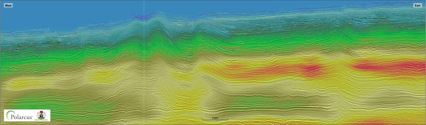 The reprocessed pre-stack depth migration section is located offshore Nigeria on the south-western margin of the Niger Delta. The latest tomographic velocity model is co-rendered as the colored overlay on the pre-stack depth migrated line below. (Processing courtesy of Down Under GeoSolutions)
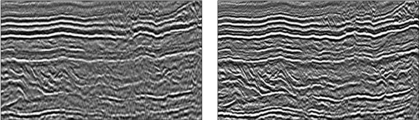
A clearer picture
References
Related Articles


