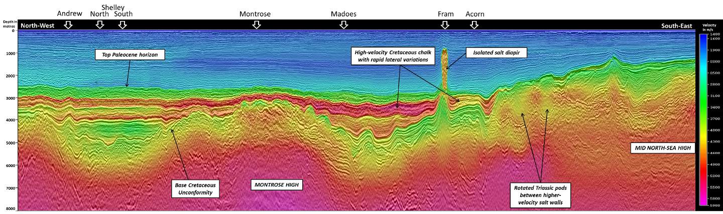
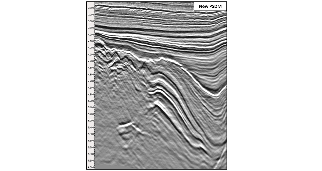
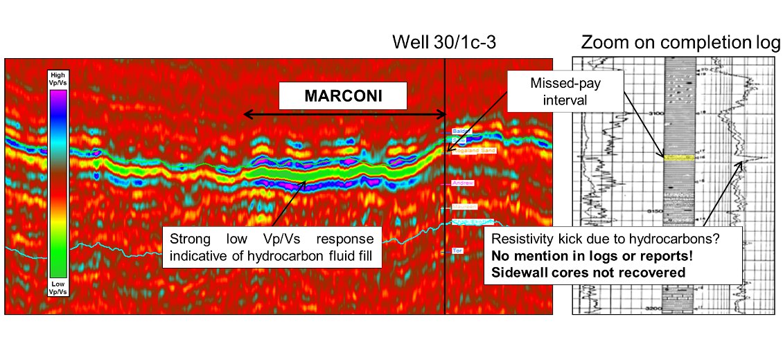
High-quality and well-positioned seismic data are key requirements of the decision-making process to recover the remaining and bypassed hydrocarbons in mature areas. A great deal of seismic exploration has taken place within the Central North Sea (CNS), using a variety of acquisition configurations including the latest broadband solutions. Through decades of exploration, most surveys in this mature basin have been reprocessed multiple times as techniques have evolved and, every so often, significant advances in technology warrant the application of these new approaches in a wholesale way. This is what CGG has recently achieved with new seismic acquisition and reprocessing of key multi-client surveys covering the entire Central Graben in the North Sea. Well known for its challenging seismic imaging, the Central North Sea still harbours a wide range of exploration opportunities. The imaging challenges arise from several aspects of the CNS’s unique geology: relatively shallow waters (less than 100m), near-surface Pleistocene channels and iceberg scours, the presence of a thick layer of Cretaceous chalk, Permian salt diapirs and associated complex deformations, highly faulted and rotated fault blocks capped by a major regional unconformity, i.e. the Base Cretaceous Unconformity (BCU), and an overall thick overburden which pushes many reservoir targets very deep into the high-pressure high-temperature (HPHT) domain. The need for greater accuracy of deep imaging and structural interpretation has seen a steady rise in the number of pre-stack depth migration (PSDM) projects. Recent developments in multi-layer tomography (TomoML) now allow complex PSDM projects to be completed within a significantly reduced timescale while at the same time improving image quality. The project incorporated 35,000 km2 of seismic data acquired across ten quadrants of the UK and Norwegian Central North Sea, from UKCS Quadrant 38 in the south to UKCS Quadrant 15 in the north (see map above), making it one of the largest single-model PSDM projects ever undertaken. Most of the surveys were conventional flat towed-streamer acquisition. However, three of the more recent surveys were acquired using the BroadSeis™ variable-depth streamer broadband solution (Soubaras, 2010) with 8 km maximum offset. In addition, a 9,000km2 area benefits from dual-azimuth (DAZ) coverage where broadband seismic data have been acquired orthogonally to the underlying legacy survey. This provides enhanced illumination of the complex structures beneath the BCU where it is deeply buried in the Central Graben. The main objective of the project was to obtain a high-quality, fully processed depth image through PSDM. In order to draw the best out of the depth imaging, three key technologies were added to the processing workflow: the latest shallow water and short period multiple suppression algorithms, frequency bandwidth extension provided by advanced ghost wavefield elimination (GWE) techniques in the τ-p domain (Wang et al., 2013; Poole et al., 2013), and high-reliability tomography using a multi-layer non-linear approach to build an accurate regional velocity model. The initial velocity model and subsequent iterations of tomography along with anisotropy parameters were calibrated to ten horizons and 225 wells in total. Anisotropy was accounted for through tilted transverse isotropy in the velocity model with the main axis set perpendicular to the horizon framework. The key horizons used were: Top Sele Formation, Top Cretaceous Chalk, Top Plenus Marl Formation (Near Base Chalk), Base Cretaceous Unconformity, Top Salt, where diapirs pierced through shallower layers, and Base Zechstein. The final model reveals geologically consistent regional trends in the velocities. This is demonstrated in the ‘foldout’ image (seismic line shown above) cutting through some of the main structures and fields of the Central Graben such as Andrew, Montrose, Madoes and Fram. Much of the exploration potential remains in the deeply buried Mesozoic structures below a thick Upper Cretaceous chalk interval, which presents many challenges for achieving stable velocities with reflection tomography. Thin layers, complex facies transitions, large vertical velocity contrasts and the reduced offset range of reflection events within high-velocity layers all make inversion difficult. Despite these challenges, multi-layer tomography was successful in producing a reliable velocity field, which is clearly seen in the ‘foldout’ image above. With the addition of GWE, a broad bandwidth was achieved, which further enhanced imaging at depth due to a strengthening of the low frequencies without compromising the higher ones. Combined with a powerful demultiple, the final results show significant improvements over existing narrow-bandwidth PSTM data, hence offering a new look at deep Mesozoic and Palaeozoic structures of the Central Graben. Complementing the seismic image, a range of seismically derived attributes is currently being processed to help extract the maximum information from the data. Targeting the HPHT plays and with the help of strong low frequencies and a stable velocity field, a quantitative 3D pore pressure prediction can be generated from seismic data. The methodology requires calibration of well data, close to 100 wells in this case, with formation pressure measurements, P-wave velocity and density logs. Eaton’s empirical law (Eaton, 1975) is used to characterise the relationship between formation pressure measurements and P-wave velocities. Moreover, the extraction of Amplitude Versus Offset (AVO) attributes was helped by the stable velocities obtained from the multi-layer tomography, calibrated anisotropy parameters and properly depth-imaged seismic offset gathers. Relying on the quality of data conditioning and amplitude preservation through the various steps of seismic processing, a relative prestack elastic inversion is processed to generate AVO attributes. This process requires no well control so the inversion results are not biased and purely data-driven. The attributes can be used for qualitative AVO screening, looking in particular at the remaining Tertiary plays and prospects in the Central Graben. The figure below shows an example section sliced through the Marconi field (also known as Vorlich) characterised by a prominent low Vp/Vs anomaly. This field was re-discovered in 2014 after well 30/1c-3, drilled in 1985, missed the main pay in the Paleocene-Eocene Cromarty sands. Although the first well penetrated a thin 3m sand interval associated with a high resistivity kick on the wireline logs, no further tests were carried out and hydrocarbons were missed, thus demonstrating the need for reliable AVO screening.
The case study presented here demonstrates how the latest technologies in seismic processing and regional reservoir characterisation can be combined to provide a full suite of data and help explore the remaining potential of the Central North Sea. We fully answer the needs of a mature basin with over 35,000km2 of contiguous 3D seismic data, including a seamless PSDM volume with stable velocities for accurate imaging, broad bandwidth for resolution at all depths and dual-azimuth coverage in geologically complex areas for better illumination. These data are complemented with a seismic velocity-derived pore pressure prediction volume over 16,100km2 targeting the HPHT domain of the Central North Sea, along with un-biased AVO attributes generated over the entire Central Graben for qualitative screening of potential hydrocarbon anomalies and prospects.
UK Continental Shelf: Raising the bar for regional 3D seismic in the Central North Sea
Exploring the Remaining Potential of the Central North Sea
The right seismic in the right place
Beyond the seismic reflection image
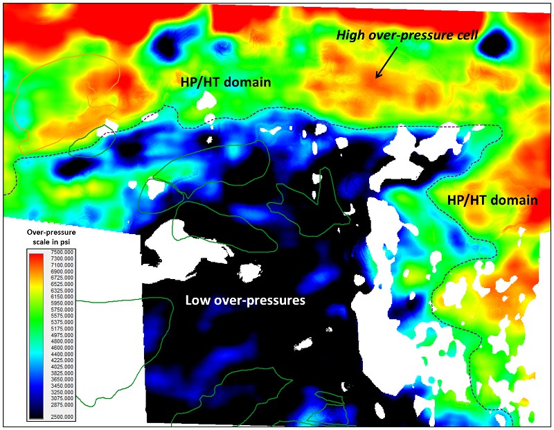 Example map of average over-pressure through the Jurassic section around the Appleton and Fulmar fields.For this study, the Central North Sea stratigraphy is divided into four main rock units defined by key horizons used in the velocity model building: the Tertiary-Quaternary siliciclastic deposits, the Upper Cretaceous chalk, the Lower Cretaceous siliciclastic unit and the pre-Cretaceous rocks. Eaton’s parameters are then calibrated independently for each unit and normal compaction trends are adjusted accordingly. In other words, this has the effect of removing the dominant rock type and matrix component from the seismic velocity field so that we only look at its pore component. Another reason for dividing the stratigraphy into four units is that each of them is subject to different over-pressure mechanisms that need to be addressed by independent calibration of Eaton’s parameters. For example, the Tertiary section is dominated by disequilibrium compaction processes, whereas the pre-Cretaceous carries a significant component of unloading and fluid expansion due to past erosion, uplift and ongoing hydrocarbon expulsion from the mature Kimmeridge Clay source rock. Using this methodology, an estimation of pore pressure trends can be extracted from seismic velocities. This is being processed over a target zone of 16,100km2 over the HPHT domain of the Central Graben.
An integrated approach
Related Articles