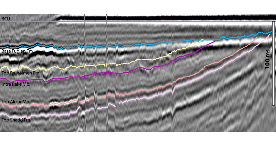
In 2014, 5,600 km of very high resolution 2D seismic data was acquired by MCG ASA and Exploro ASA in the Hoop Area of the Norwegian Barents Sea. The data ties in all the recent wells and covers 13 of the announced blocks for the 23rd Concession Round for offshore Norway. The dataset is uniquely suited to mapping out the shallow Upper Triassic to Jurassic prospectivity in the area in great detail. Using super-high resolution seismic data in the Hoop Fault System area of the Barents Sea allows for the clear imaging of very shallow reservoirs, with AVO effects visible even at shallow depths. The area surrounding the Hoop Fault System in the Norwegian Barents Sea is at present among the most prospective and enigmatic areas being offered in the 23rd Concession Round. Over the last year and a half, six wells have been drilled, two of which led to potentially commercial discoveries in the Jurassic, namely Wisting and Hanssen. An interesting characteristic of the area is that the prospective Jurassic reservoir rocks occur at very shallow depths; the reservoir of the Wisting discovery, for example, is only around 400m below the sea floor. In fact the prospective Jurassic reservoirs are mainly located above the first sea floor multiple in most of the area. The reason behind this is that we are looking at an exhumed petroleum system. The Hoop area experienced between 1,500 and 2,000m net erosion during the Cenozoic. This setting has enabled Exploro and MCG to design a regional super-high resolution multiclient 2D seismic survey, which is particularly suited to map the prospectivity of the Hoop area in great detail, as well as investigate reservoir distribution and fluid contacts. A 2 by 8 km 2D seismic grid has been acquired using site survey parameters. Full modern broadband processing was carried out by Down Under GeoSolutions (DUG). Near zero offset data was acquired, which is optimal for the processing of the data. A 2,000m-long streamer was used in order to be able to undertake AVO work, which is normally not possible at the shallow depths we are dealing with in the Hoop area. The data was sampled and processed at 1 ms and with a group length is 6.25m. Figure 1 shows a comparison between conventional 2D seismic in the area and data from the new high resolution survey, known as MCG1401. The Hoop Fault system is a long-lived series of faults that has been periodically reactivated at least since the Carboniferous. Structuration in the Jurassic and Cretaceous resulted in the formation of the structural traps that are being explored in the area at the moment. Potential reservoirs occur in the mid-Triassic to mid-Jurassic Kapp Toscana Group, and consist mainly of continental to marginal marine sandstones. Reportedly, the reservoir quality was excellent in the Wisting and Hanssen discoveries. The regional top seals are made up of the Upper Jurassic Fuglen and Hekkingen Formations. Figure 2 shows an example of the detailed seismostratigraphic interpretation that is achievable with the new data. The section has been flattened on the Base Cretaceous Unconformity in order to enhance the internal variation of the potential Upper Triassic to Jurassic reservoir units. Here the Realgrunnen Sub Group has been subdivided into four units. The Lower constitutes the heterolithic Akkar Member of the Fruholmen Formation. The unit thickens towards the left in the section. Above sits the thick sandy Reke Member of the Fruholmen Formation, which has been sub-divided into two units here. The uppermost part of the Fruholmen Formation seems to be characterised by channels, which are probably fluvial in nature. The sandy Stø Formation is located above as a wedge thickening towards the left. The variation in thickness is partly due to local late Jurassic erosion. The high amplitude reflector cross-cutting the strata in the left part of the Stø Formation corresponds to a flatspot in the normal (un-flattened) section. There is no shortage of source rocks in the Barents Sea, and the most likely contributors to the prospects in the Hoop area are marine oil-prone Lower Triassic and Upper Jurassic sources. Hydrocarbon systems modelling carried out by Exploro has demonstrated that expulsion from the Upper Jurassic Hekkingen Formation in the Maud Basin migrating updip through Jurassic sandstones is sufficient to charge the Wisting and Hanssen discoveries as well as several undrilled prospects in the area. The main critical aspect to the petroleum system in the Hoop area is the Cenozoic uplift and erosion. Based on this new multiclient 2D data, several potential prospects with variable sizes (the largest covering several blocks) have been identified in the Hoop area. Many of these are associated with DHIs. Fluid contacts are mappable and consistent in depth over several lines for some of the potential prospects. The wells drilled in and close to the Hoop area have demonstrated large lateral thickness variations in the Kapp Toscana Group reservoirs. The new super-high resolution seismic data will enable us to map out the lateral extent of each potential reservoir. The example in Figure 3 clearly demonstrates AVO effects at shallow depths in the data. The section crosses an undrilled structure in PL722, operated by GDF Suez. The angle stacks show an increase in negative amplitude with offset, which indicates a possible AVO Class III response. The super-high resolution 2D seismic survey will enable seismic interpreters to establish a much more detailed stratigraphic framework than is possible with other data in the area, as well as mapping fluid contacts and ideally separating one-phase traps from two-phase traps. In these challenging times with reduced exploration budgets, the new data will enable oil companies to license less 3D seismic data in this highly prospective and promising area.
Super-high resolution seismic data in The Hoop Area Norwegian Barents Sea
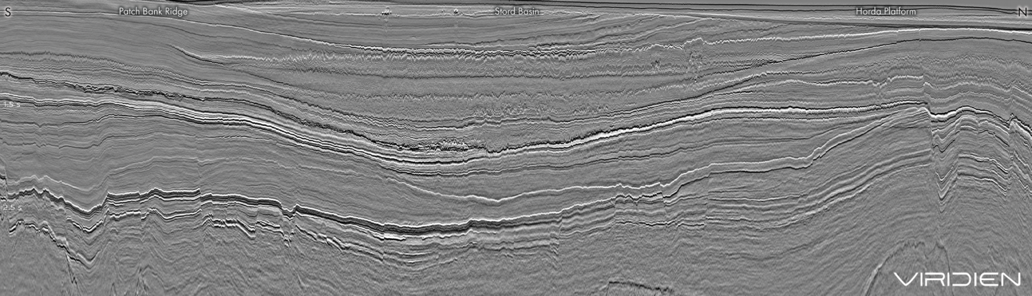
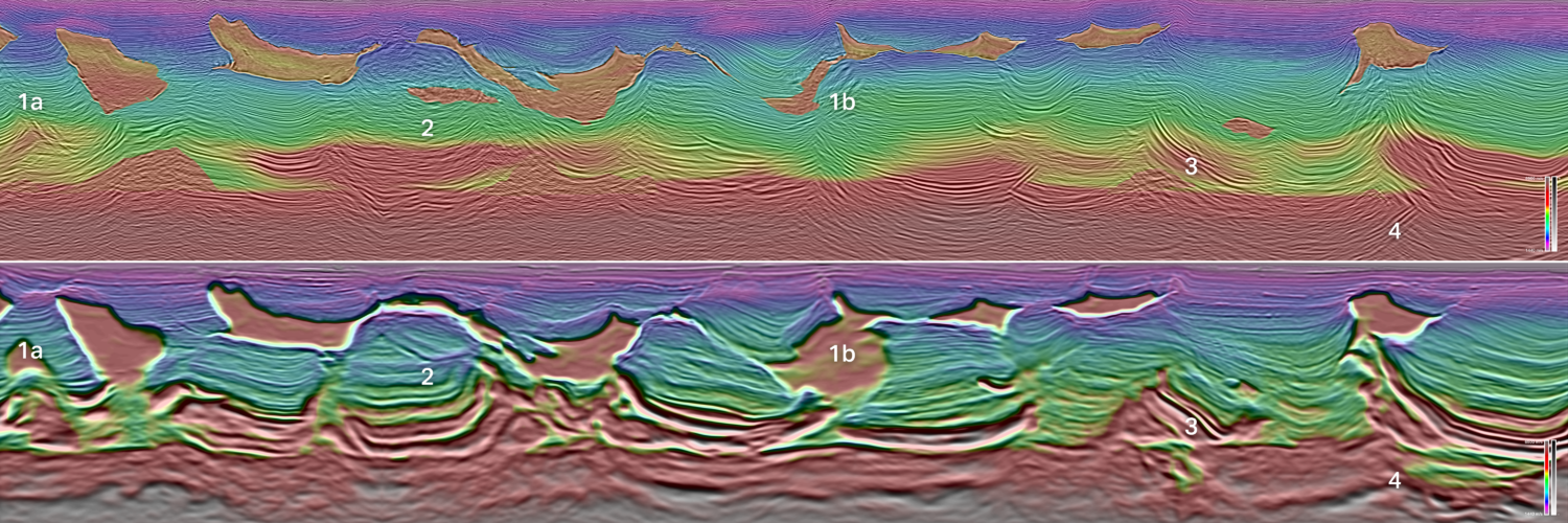
 Semi-regional 2D super-high resolution seismic line in the Hoop Area. (Source: MCG/Exploro).

Imaging shallow reservoirs
Very shallow discoveries

Elements of the petroleum system
Prospectivity and Data
Related Articles