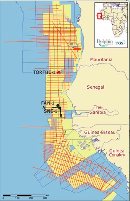
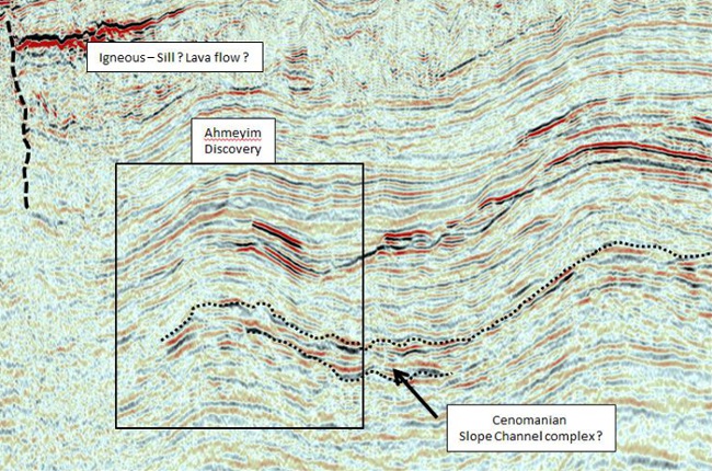
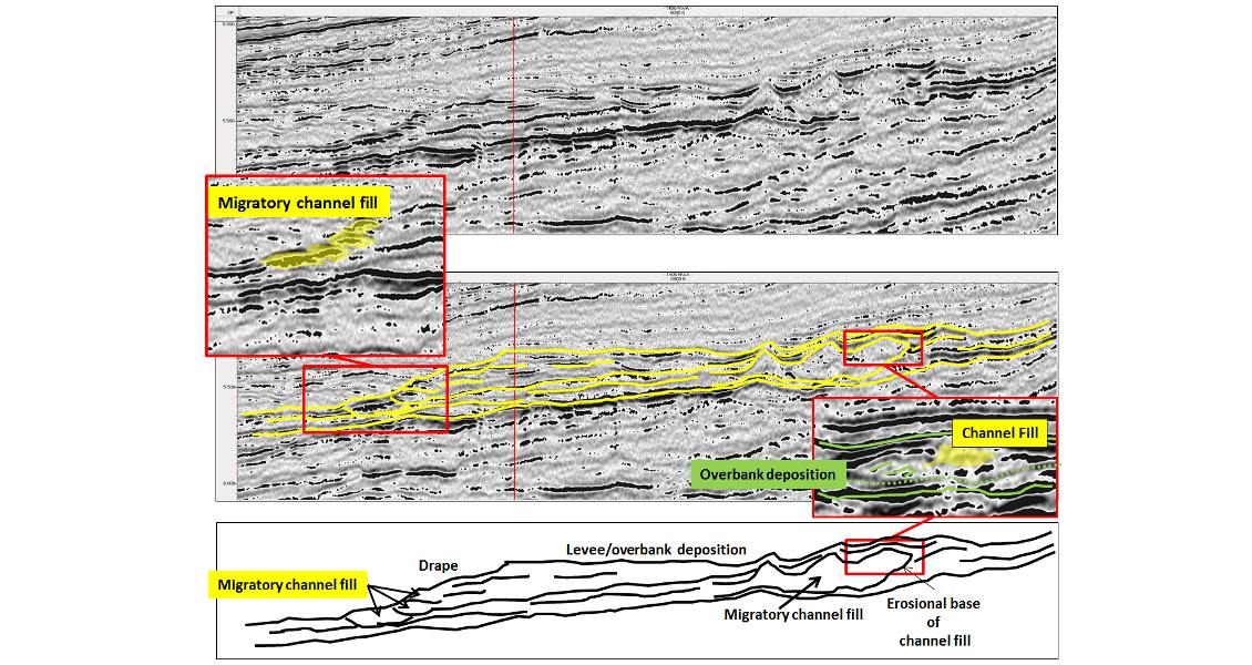
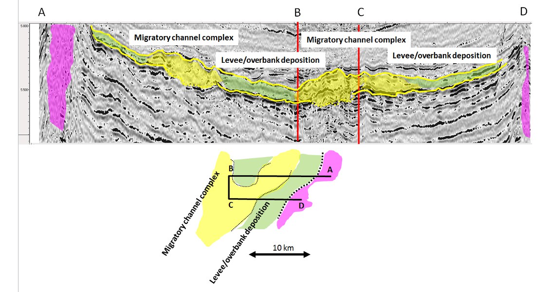
Revisiting a 2D regional seismic dataset and integrating information from recent significant discoveries. The North West Africa Atlantic Margin (NWAAM) region was underexplored for many years, but since the discovery in 2007 of the Jubilee Field by Kosmos Energy in Ghana, industry has refocused efforts to explore similar plays around the entire West and North West Africa coast. On October 7th, 2014, Cairn Energy announced an important and potentially commercial oil discovery in the Sangomar Deep block offshore Senegal. The FAN-1 exploration well recovered light oil from a series of stacked Cretaceous sandstones, with APIs ranging from 28° up to 41°. Cairn Energy drilled a second well, SNE-1, offshore Senegal in 1,100m of water and announced, on November 10th, 2014, that they had made an additional discovery. Initial analysis of the well, as reported by Cairn Energy, showed a 95m gross oil-bearing column with a gas cap, excellent reservoir sands with net pay of 36m of 32° API oil and a P50 contingent resource of 330 MMbo. Kosmos drilled their first well offshore Mauritania in block C8 in early 2015. The Tortue-1 exploration well made a significant and play-opening discovery and, based on preliminary analysis of drilling results, encountered 117m of net hydrocarbon pay. The Tortue discovery area has been renamed Ahmeyim. The Cretaceous slope/channel complexes are imaged throughout the NWAAM seismic survey. Newly acquired and reprocessed seismic reveals potential masked by complex geometries. In 2011 TGS and Dolphin Geophysical acquired a regional seismic dataset (NWAAM) consisting of 17,764 km of 2D seismic with a record length of 9 seconds and which covered the margin of four countries – Senegal, The Gambia, Guinea Bissau and Guinea Conakry. This survey was followed by the acquisition of NWAAM Phase 2, which again was jointly acquired by TGS and Dolphin Geophysical in 2012. The Phase 2 survey consists of some 11,212 km of 2D seismic data with a record length of 14 seconds and covers the entire offshore margin of Mauritania. The location of the combined NWAAM datasets, and associated recent discoveries, are shown on the location map in Figure 1, above. The offshore geology of the NWAAM has been shaped by the evolution of the rift system that started with the Late Permian breakup of the African, North American and South American Plates. The area underwent three main tectonic phases: pre-rift, syn-rift, and post-rift. The pre-rift phase occurred in the Proterozoic-Paleozoic, the syn-rift phase in the Permo-Triassic, and a post-rift/drift phase occurred up to the present day (Brownfield and Charpentier, 2003). All the elements of active petroleum systems have been confirmed by drilling, with source rocks proven in the Barremian, Cenomanian, and Turonian by deep sea drilling (DSDP-367). Exploration wells to date have proved a range of sandstone reservoirs ranging from Early Cretaceous (Loup de Mar-1), through Late Cretaceous (Faucon-1), to Late Tertiary (Chinguetti Field). Figure 3 – NWAAM 2D seismic across the Ahmeyim discovery. (Source: Dolphin/TGS)Kosmos’s Ahmeyim discovery was made by the Tortue-1 well, which found 107m of net pay in the primary Cenomanian objective, and another 10m of pay in a lower Albian section. The Tortue-1 well was designed to test the western closure of a series of Upper Cretaceous slope/ channel reservoir systems in combination structural/ stratigraphic traps. The seismic line from the NWAAM dataset (Figure 3) lies seven kilometers to the south of the Tortue-1 well but covers the southern end of the Ahmeyim discovery. The preliminary estimate of the gas volumes for Ahmeyim are of the order of 5-8-12 Tcfg (Kosmos, Mauritania Exploration Update, 2015). The Tortue-1 well proved the very high potential of the Cretaceous slope/channel corridor that extends along the Mauritania and Senegal margins. Following the discovery we revisited the regional scale interpretation to see what we could deduce from the 2D seismic in the light of this new information. Figure 4 outlines what we believe to be the internal architecture of a line perpendicular to the channel axis of a complex lying to the north of the Tortue-1 well. Essentially, two basic seismic characters can be seen – mounded structureless areas (showing compactional drape above), surrounded by variable dipping reflectors. The complex geometries are a result of the interplay between migratory channels and their associated overbank/levee deposits. On the left-hand side of the section a smaller migratory channel system has been interpreted. The spacing of the regional dataset is of the order of 10 km between lines shot perpendicular to the margin, but by using seismic character to distinguish between areas dominated by migratory channel complexes and their associated overbank/levee deposits, it has been possible to highlight channel-rich corridors. Figure 5 shows a composite line extending from the salt-structured eastern edge of a channel complex sequence, into the channel complex, and then back onto the eastern edge of the channel complex sequence. By simply mapping the thinning edge of the overall channel complex sequence, along with the internal ‘mounded/structureless migratory channel complex’ and the ‘layered/ reflective overbank/levee’ seismic facies, a series of complex channel corridors can be mapped for various stratigraphic levels.
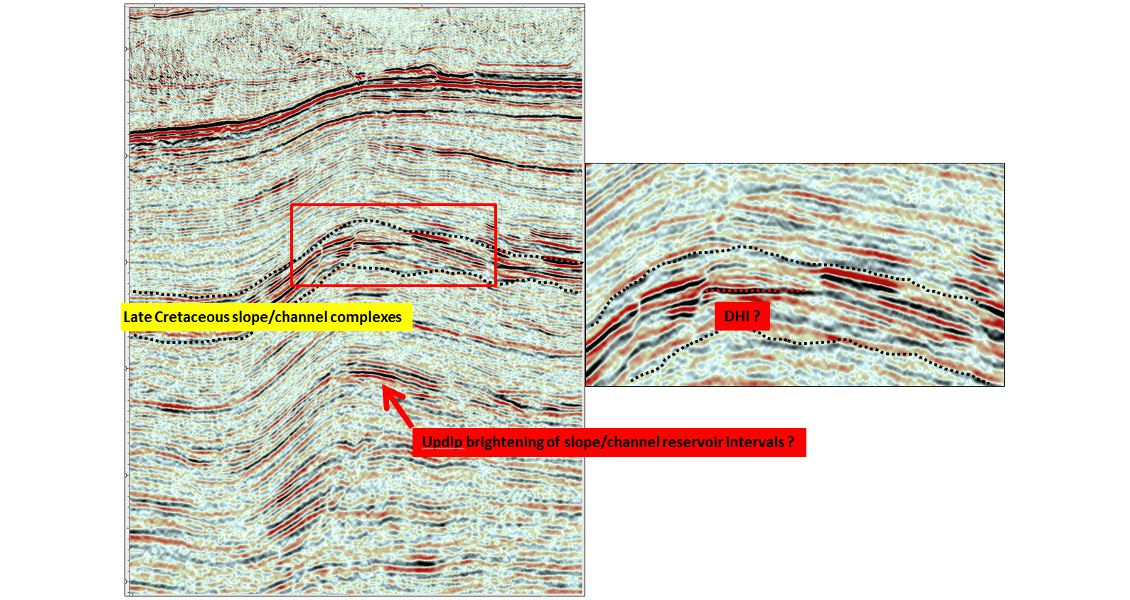
Figure 6 shows a stacked series of Cretaceous slope/channel complexes interpreted from the north of the Ahmeyim discovery, where the upper two complexes have possible DHIs (flatspots) conformable with structure.
Offshore Mauritania and Senegal
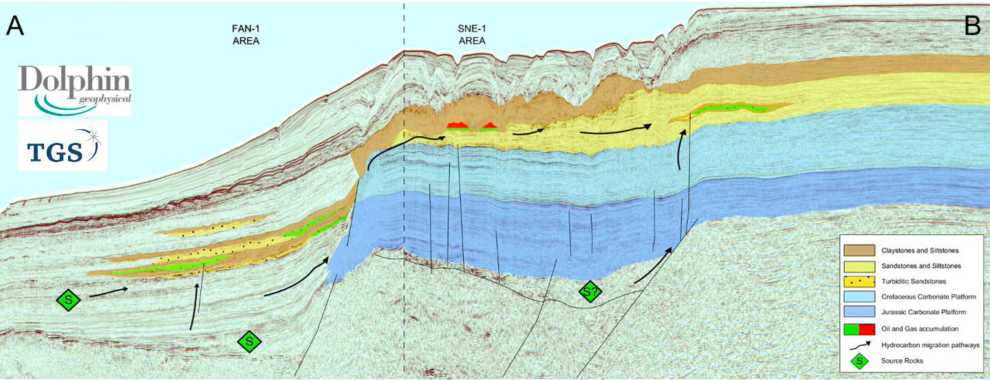 Figure 2 - Seismic traverse A-B extending through the FAN-1 and SNE-1 Areas. (Source: Dolphin/TGS)
Slope/Channel Complexes Offshore North West Africa
Geological overview
Ahmeyim Discovery
Architecture of slope/channel complexes
Related Articles


