
The Active Volcanoes of Hawai‘i
Breathtaking views, surreal landscapes, and the chance to come face to face with an active volcano, the Island of Hawai‘i offers the geotourist encounters of a lifetime, and scientists a window into a volcano’s inner workings.
Before Hawaii became a state, or even a territory of the US, it was the Kingdom of Hawai‘i ruled by a native monarchy. Honolulu native Lorrin Thurston, then a Columbia University graduate and member of the Honolulu bar, led a revolution that overthrew Queen Liliuokalani on January 17, 1893. He immediately sailed to Washington, D.C. and in two years there helped pave the way for Hawaii to be annexed to the US in 1898. He developed sugar plantations and railroads for the new territory and became publisher of a Honolulu daily newspaper. A frequent visitor to the active Kīlauea Volcano, he loved exploring the area – a lava tube he discovered in 1913 bears his name. He used his influence through his many business contacts and his newspaper to promote both a volcano observatory and a national park at Kīlauea.
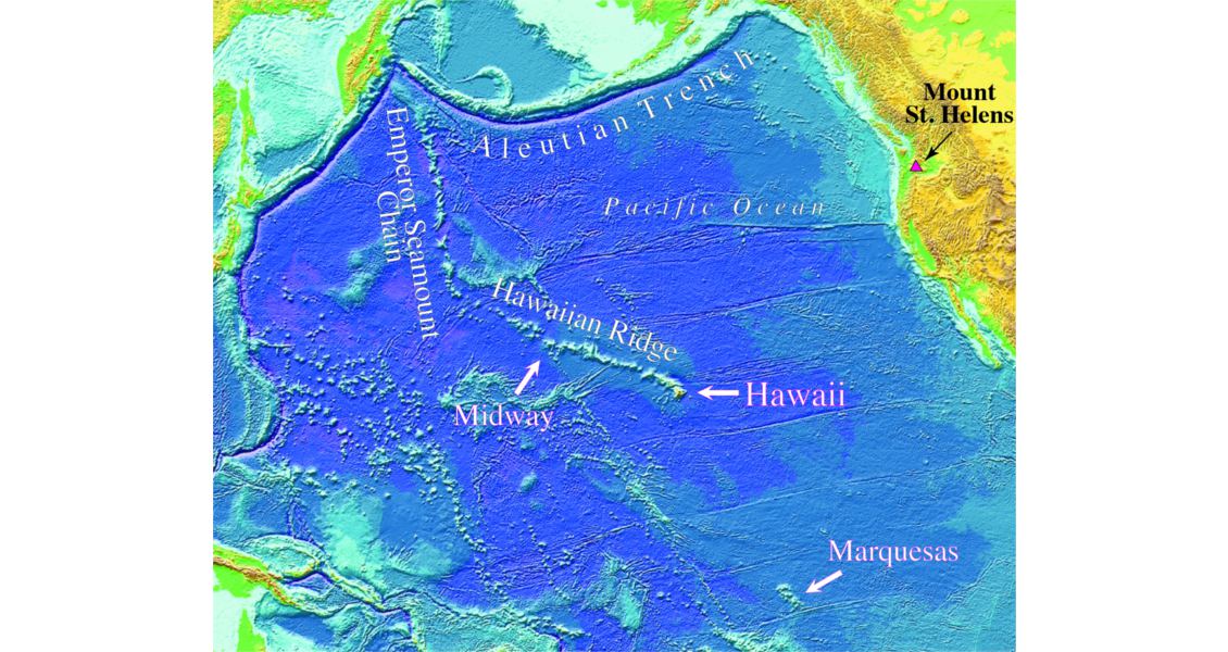
The linear trends of the Hawaiian Ridge and Emperor Seamount Chain in the northern Pacific Ocean. (Source: USGS)
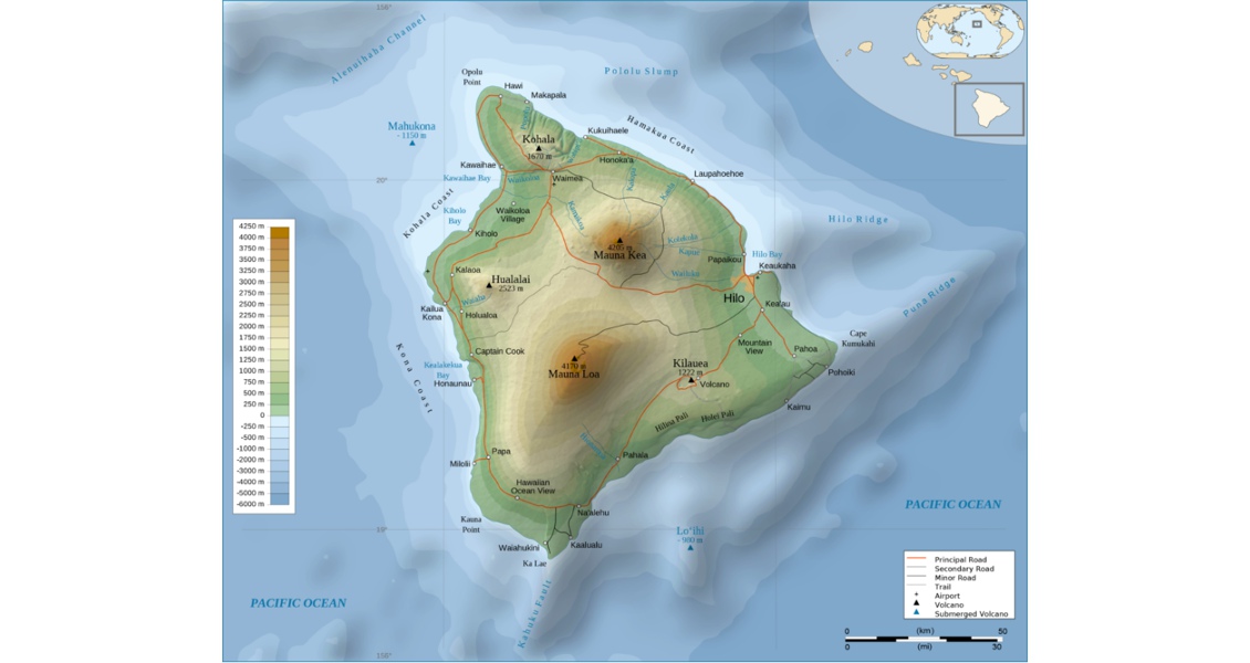
Hawaii Island topographic map. (Source: Sémhur via CC)
The Hawaiian Volcano Observatory (HVO), established in 1912, was America’s first facility of this kind. The site provided scientists with a perfect laboratory for the study of these giant volcanoes that are among the most active in the world. For the first time, scientists could continuously monitor the changes to the volcano caused from the upward and lateral movement of magma before, during and after an eruption occurred and issue warnings of the relative danger level of impending volcanic activity.
Creating a national park at Kīlauea would take some additional effort. Thurston used his newspaper and influence to bring a group of congressmen to Kīlauea in 1907 and again in 1909. He even had meals cooked over the hot volcanic vents to impress his visitors. His newspaper continued the campaign with printed endorsements of the park by President Theodore Roosevelt, conservationist John Muir, and the powerful Senator Henry Cabot Lodge. Finally, President Woodrow Wilson formally established the Hawai‘i Volcanoes National Park in 1916. It has been enlarged several times and is recognized as a UNESCO International Biosphere Reserve as well as a World Heritage Site.
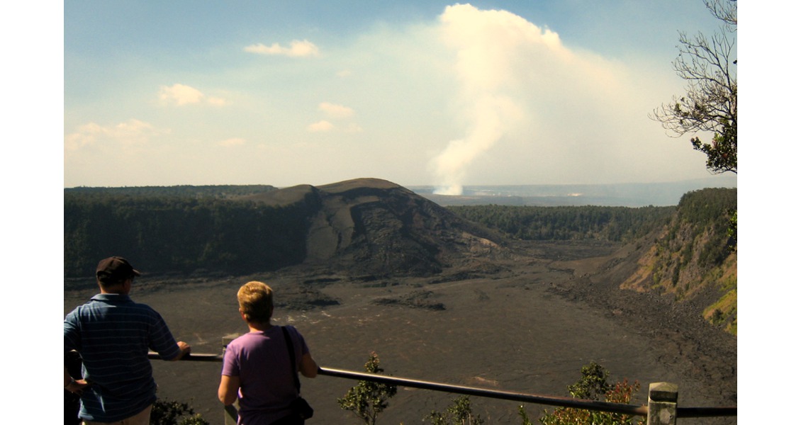
Looking across Kīlauea Iki Crater at the huge Kīlauea Caldera and the currently active Halema‘uma‘u Crater gives visitors a sense of scale of this intriguing and unique National Park. (Source: Thomas Smith)
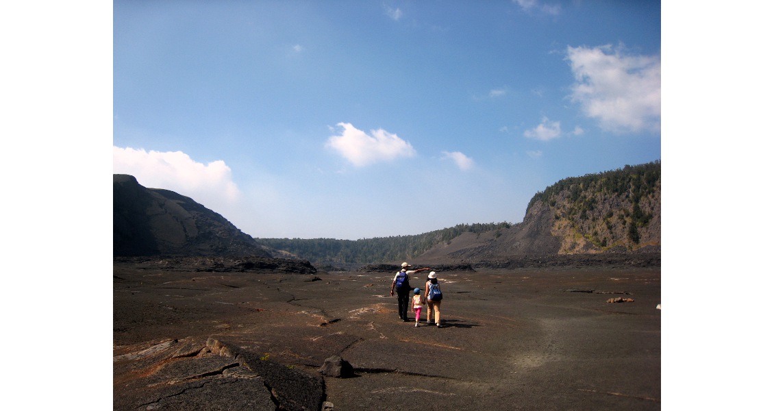
Hiking across the floor of Kīlauea Iki Crater can be a surreal (and extremely warm) experience. On November 14, 1959 a fissure erupted on the south wall of the crater. Three days before the eruption ended on December 20, 1959, the lava fountain blasted to a height of 580m above the vent being the highest ever recorded on the Island of Hawai‘i. A lava lake approximately 134m deep was formed over the five weeks of eruptions. (Source: Thomas Smith)
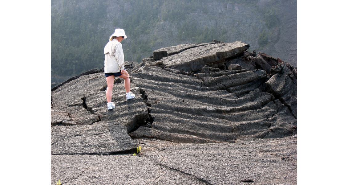
As the lava cooled and crusted over, underlying forces buckled what is now the floor of the crater, particularly along the edges. (Source: Thomas Smith)
Origin of the Island Chain
Early explorers, from the first Polynesians who began settling in the Hawaiian Islands over 1,000 years ago to the first European pioneers, noted the island’s north-west to south-east alignment. In fact, the Hawaiian Ridge extends 2,600 km from the Island of Hawai‘i, where it turns northward, becoming the Emperor Seamount Chain, continuing another 3,400 km to the Aleutian Trench. These two lineal features are made up of tall volcanic sub-sea mountains. The more than 80 large volcanoes in these two chains were formed from countless eruptions of lava, enough to bury the entire State of California over 1,600m deep.
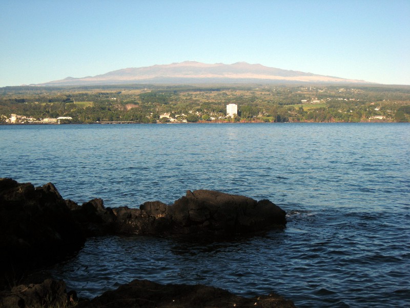 A view across Hilo Bay and the city of Hilo on the Island of Hawai‘i. The massive shield volcano in the background is Mauna Kea, at 4,205m above sea level the highest in the Hawaiian chain. To the left and out of the photo is the still active Mauna Loa, only 36m lower but the most massive mountain on earth, rising 17 km above the sea floor. (Source: Thomas Smith)Pioneering American geologist and explorer, James Dana, conducted the first geologic study of the Hawaiian Islands in 1840. He noted that the islands are increasingly younger from north-west to south-east primarily from the degree of erosion increasing in the opposite direction. (Long before, native Hawaiians had noted this: the mythology of Pele, the Hawaiian goddess of the volcano, tells of her travels from island to island until she found a home in the fire pits of Halema‘uma‘u Crater.) Dana also proposed that the alignment of the islands was caused by volcanic activity along a great fissure that crosses the ocean floor.
It was not until the plate tectonics theory was formulated in the 1960s, and, more relevant to this island chain, the work of Canadian geophysicist J. Tuzo Wilson in 1963, that Dana’s fissure theory would be challenged. Wilson proposed that the Pacific Plate’s movement over a fixed hot spot created the island chain. To test his hypothesis, he sampled volcanic rock from each of the islands. He found the furthest north-eastern island of Kaua‘i was the oldest, as had Dana over 100 years prior, and that the ages became progressively younger the further south-east he went. Additional support for Wilson’s theory is occurring today in the form of a new volcano forming south of the Island of Hawai‘i called Lō‘ihi; as the lava continues to erupt and build to the surface, it too will join the chain of Hawaiian islands.
Observing Volcanic Behavior
Similar to improvements in early oil and gas exploration methods, volcano monitoring at HVO has undergone constant refinements over the past 100 years. When Thomas Jaggar first started observing the Hawaiian volcanoes in 1909 he had a few elementary seismometers, some meteorological equipment, and a surveyor’s transit to monitor seismic activity and the changes in the shape of the volcano. Now, there are over 100 field stations that collect seismic, deformation, volcanic-gas, and geologic data, along with a vast network of other monitoring tools. What Thomas Jaggar did with a camera and a notebook now requires a bank of computers to track all of the field data.
 An array of data are collected 24 hours each day throughout the year at over 100 monitoring stations. (Source: USGS)HVO scientists use many of the same tools that the oil and gas industry use to monitor activity such as strainmeters, tiltmeters, seismic, gravity, GPS receivers, gas sensors, InSAR satellite data, and more – all to increase our understanding of how volcanoes work.
“HVO has served as a proving ground for most of the equipment used today to monitor volcanic and earthquake hazards around the world as well as a training center for volcanologists,” says Dr. Michael Poland, USGS research geophysicist. “The first true seismic network was developed here, and lessons learned from that were used to develop networks in places like California to monitor earthquake activity. The same is true for many other monitoring methods including those used before and after the May 18, 1980, major eruption of Mount St. Helens. Many of the scientists working on the St. Helens eruption were also trained at HVO. The training and ‘new gizmo’ trials that started in Hawai‘i over 100 years ago continue today.
“As for the tool to monitor and be able to predict future activity, I do not think there is one ‘best’ tool, no magic bullet, as it were,” Dr. Poland continues. “I tend to think of monitoring as a toolbox. You need a variety of tools in order to be effective at the job site and the same is true at any volcano observatory. Some eruptions have been presaged by certain types of signals, while other times those same signals are not so strong. You need to have a diverse approach to monitoring.”
Indeed, like any successful oil and gas company, HVO employs scientists of many disciplines and a wide array of methods to follow volcanic activity, which has enabled scientists to learn much more about the inner workings of the Hawaiian volcanoes. Their findings are published in both scientific papers and on their website, keeping other scientists and the public informed about Hawaii’s volcanic activity.
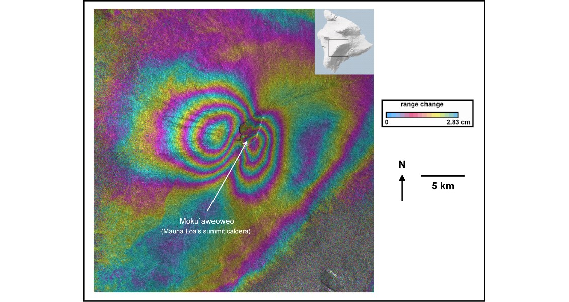
Interferograms derived from interferometric synthetic aperture radar (InSAR) satellite data, first used in Hawai‘i in 1994, are now routinely used to map surface deformation on volcanoes around the world. This interferogram shows rapid deformation at the summit of Mauna Loa in the 2004–2005 period. The color bands record a complex pattern of several inches of inflation of the magma reservoir. (Source: USGS and the ESA)
Living on an Active Volcano
When I interviewed Dr. Poland at HVO last December, I was very interested in all the various tools he had at his disposal and took away a new respect for both these scientists and the people living in this ever-changing environment.
Visitors come to the Island of Hawai‘i to enjoy the tropical fruits, beautiful flowers, stimulating coffees grown from the rich volcanic soils as well as the spectacular mountain and ocean scenery. When eruptions occur, we are a witness to nature’s show like no other. Those who call Hawai‘i home enjoy the same great qualities that attract visitors but must live day-to-day with the potential hazards such as poor air quality caused from the eruption gasses emitted from Kīlauea, property loss from frequent earthquakes, and dangerous lava flows.
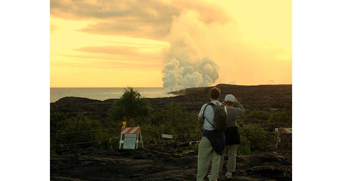
Lava flowing into the sea creates a steam cloud and a brilliant red glow at sunset. This lava has flowed down from the Puʻu ʻŌʻō eruption that began on January 3, 1983 and continues today making it Kīlauea’s longest East Rift Zone eruption. Flows from these ongoing eruptions have been very destructive. In 1990, an entire community, including more than 214 structures were buried beneath nearly 25m of lava. Recent flows continue to threaten homes and roads in this area. (Source: Thomas Smith)
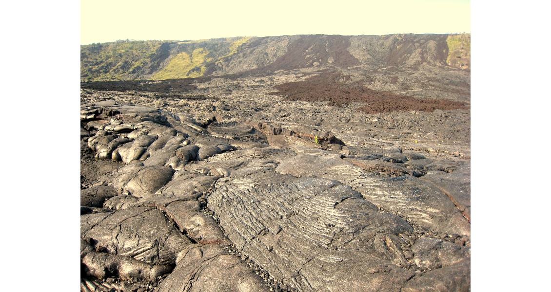
Pāhoehoe basalt interspersed with ‘a‘ā basalts (reddish black and blocky) poured over Hōlei Pali (500m bluff in the background) and into the ocean from the 1969 to 1974 Mauna Ulu (Growing Mountain) eruption on Kīlauea’s East Rift Zone. These lava flows covered 46 km² and added 93 hectares of new land. (Source: Thomas Smith)
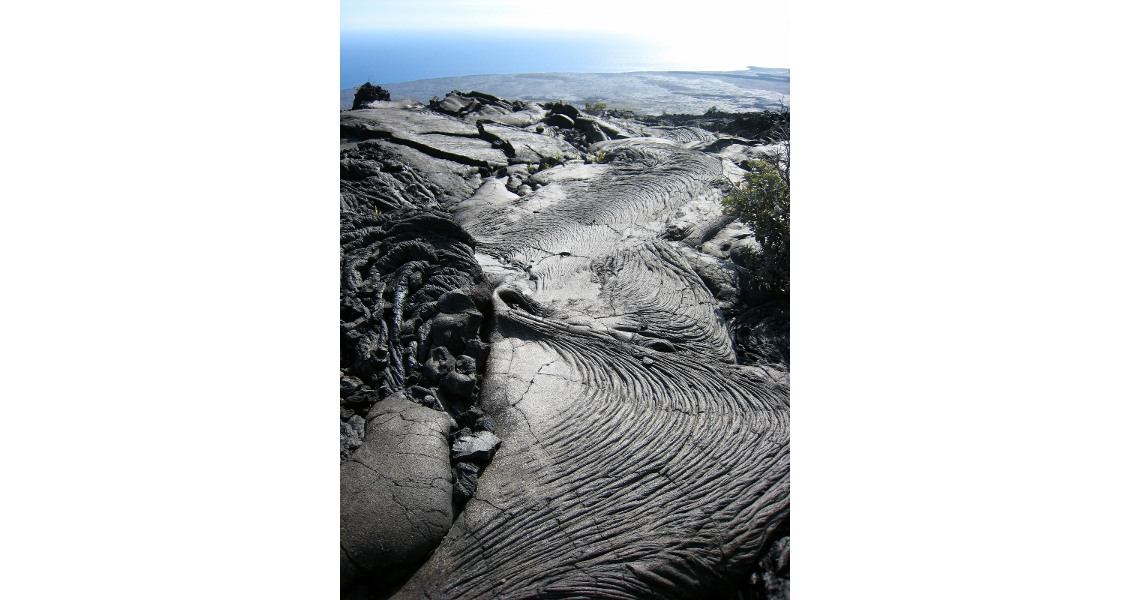
Ropey pāhoehoe basalt viewed along the Chain of Craters Road directly south of Kīlauea Caldera. (Source: Thomas Smith)
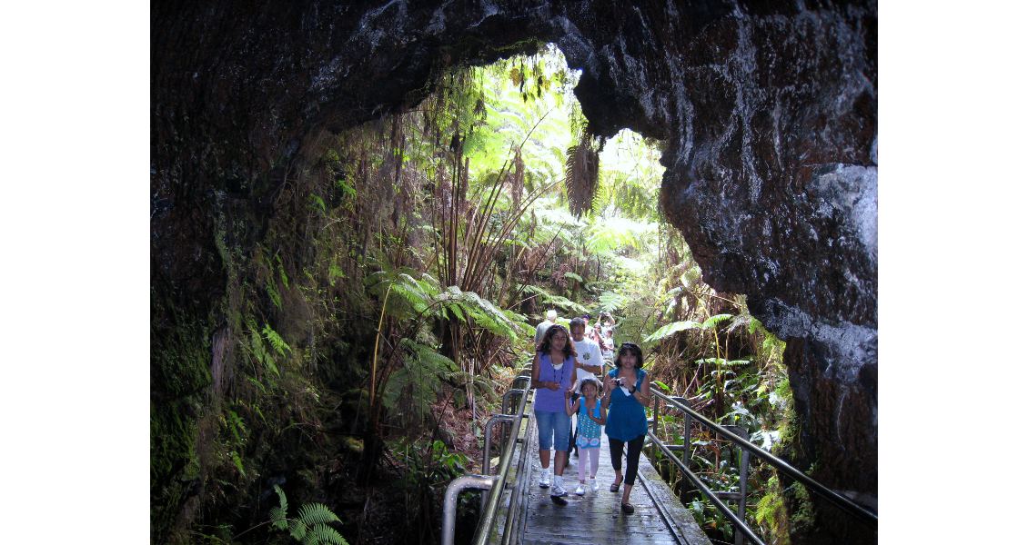
After a short walk through a lush tree fern forest, the dark confines of the Nāhuku-Thurston Lava Tube comes into view. The now lighted cave carried red hot lava several hundred years ago that fed one of the many flows that make up this part of the island. (Source: Thomas Smith)
“Standing next to fountaining lava during an eruption is a very overwhelming experience,” says Dr. Poland. “You smell, taste, hear, see and feel an event that you have no control over. It is absolutely overwhelming. Then, when the lava flows toward populated areas, it can have a huge impact on the people and society. Most of the scientists at HVO live here and feel the volcano’s consequences on the environment and people, both the benefits of what it brings to us as well as its destructive nature.”


