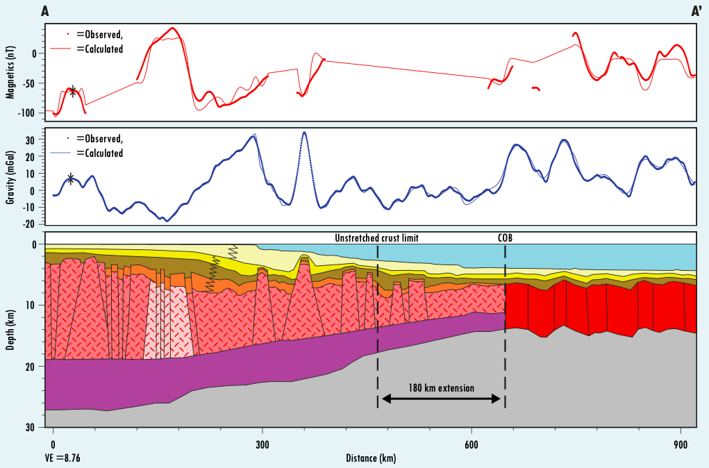
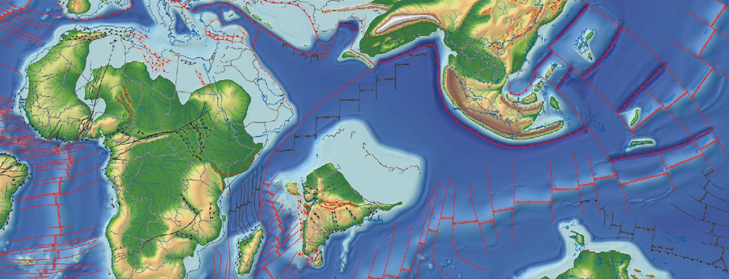
Dirk Cuthbertson from Getech shares some insights from their global plate tectonic model, part of Globe, Getech’s flagship new ventures platform. Well and seismic data can be very sparse in frontier regions; however Getech’s extensive global gravity and magnetic database, the largest commercially available dataset of its kind, covers almost all the sedimentary basins of the world. It is a superb resource for mapping the structural framework of the world, which helps us to better constrain our global plate tectonic model. An example of a Getech plate scale structural interpretation.Our Trident satellite gravity data, derived from stacking three independent solutions of re-processed altimeter data from the ERS-1 and Geosat satellites, covers all of the ice-free continental shelves of the world with a minimum wavelength resolution of around 10 km. We are currently halfway through a three-year project to incorporate additional altimeter data from the CryoSat-2, Jason-1 and HY-2A satellites, which will generate a more accurate, reliable and coherent solution, particularly near coastlines. The continental regions of the world are covered by both gravity and magnetic data from Getech’s many continental-scale compilations, supplemented for many countries by higher resolution data including, for example, Tanzania, Mexico, Mongolia, the onshore US and eastern Europe. These datasets provide both detail at the block scale and insights into the regional context. The emergence of international unconventional hydrocarbon plays has also expanded the scope for using these data. Published literature is a great resource for ideas, data and maps. Comparing published maps against our gravity and magnetic interpretations can often expose complexities and what appear to be relatively small inaccuracies, both of which have a big impact on our plate tectonic models. We also incorporate other data to help constrain our plate modelling, including: published seismic and geological cross-sections, magnetic picks, well and outcrop data, digital elevation models, Landsat imagery, geological maps and apatite fission track data. The 85E Ridge offshore eastern India manifests as a gravity low in Getech’s Trident satellite gravity data, although very little is known for certain about its crustal nature. If it is a continental fragment, which is one hypothesis, then the prospective area for hydrocarbons is much expanded. Between the ridge and India, however, there is little evidence in gravity, magnetic or seismic data of a relict spreading centre, fracture zones are not of an orientation consistent with this movement, and isochron data (Ramana et al., 2001) show a younging to the south-east over any possible location for a spreading ridge. These isochrons are shown on the map below: orange is Chron M11 (136.29 Ma), green – Chron M10N, yellow – Chron M10, and red is Chron M8 (133.05 Ma). A major challenge for the plate model that honours this data and a continental 85E Ridge is to provide enough space for the production of oceanic crust in the southern Bay of Bengal for the period 136–127 Ma whilst keeping other boundary conditions unchanged. To do this the Indian Plate must move 1,300 km northward relative to Madagascar during this time. Solutions for relatively small scale regional tectonic problems like this must be incorporated into the complete plate tectonic circuit in order to fully assess their impact. Slab-pull or extrusion tectonics? What is the formative mechanism and timing of the opening of the South China Sea? Extrusion models, such as that of Leloup (1995), predict that in the south- western corner of the South China Sea, crustal north-east to south-west stretching can be no less than 250 km (more if the extension required to produce accommodation space in the Song Hong Basin is included). Getech’s 2D gravity and magnetic modelling in this region (see profile A-A’, below) shows that extension can be no more than 180 km. If a slab-pull mechanism (associated with subduction of a proto-South China Sea plate under present-day Borneo) is modelled, then this limit of stretching is not exceeded. An earlier opening and thus rifting history is implied, however, and this affects our understanding of the petroleum systems of this region, particularly the maturation history of any source rocks and the relative timing of changes to hinterland drainage and the impact on reservoir distribution. How do plate tectonic models help develop an exploration programme? Firstly, a better understanding of the relative and temporal juxtaposition of hinterland elements to play elements within sedimentary basins can reveal new insights into their prospectivity. If your play models rely on, say, a granitic source for reservoir sediments during a particular stratigraphic stage, then our plate model can tell you if that is likely. Secondly, rotating your data from their Present Day locations back in time can help you understand the palaeogeographic context of your exploration acreage. With Globe, Getech’s flagship new ventures platform, we take this a little further. Our global plate model is the foundation for a series of 59 palaeogeographic maps and palaeolandscape models, one for each stratigraphic stage back to the Permian, one of which is shown below. These are used to generate palaeoclimatic, palaeoceanographic and palaeotidal models for each timeslice, each revealing new insights into the distribution, quality and preservation of the various elements of any petroleum system. If well constrained by data, a global tectonic plate model can be built which takes account of small scale tectonic issues whilst ensuring that the integrity of the entire plate circuit is not compromised. This plate model then becomes a fundamental exploration tool, enabling a better understanding of hydrocarbon prospectivity by revealing the regional geological context for any element of the petroleum systems of a sedimentary basin.
Global plate tectonic modelling
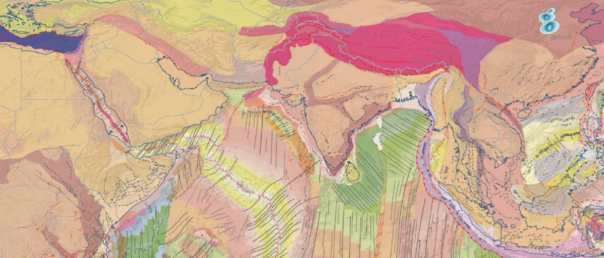
Constrained By Data

Two examples from Getech’s Globe global plate tectonic model
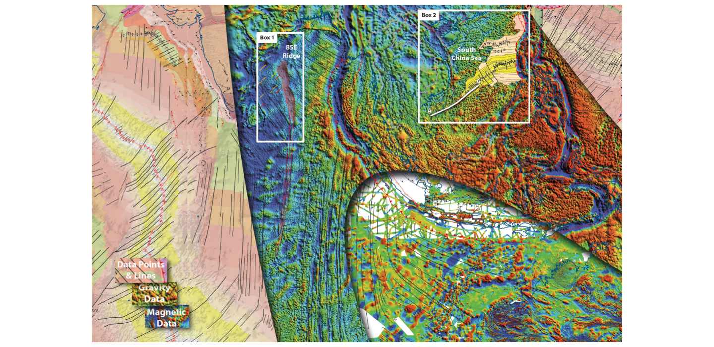
Box 1: The nature of the 85E Ridge and its impact on plate tectonic history
Box 2: Opening history of the South China Sea
Uses of plate models
Conclusions
Related Articles


