
Erbil. Ancient City – and ‘Second Dubai’
Contrary to many people’s expectations, Erbil, the capital of Iraqi Kurdistan, is a peaceful, busy and surprisingly modern city, with a history that stretches back over 7,000 years.
Erbil, known as Hewlêr (Kurdish: Hewlêr; Arabic: Arbīl ), is the capital and largest city of the Iraqi Kurdistan Region, and is the third largest city in Iraq. It is located 88 km east of Mosul and has a permanent population of approximately 1.5 million (as of 2013).
Spared much of the violence which beset Iraq through the first decade of the 21st century, Erbil is a lively and modern city which prides itself on its new shopping malls, five-star hotels and skyscrapers under construction, revelling in the, possibly slightly optimistic, label of the ‘Second Dubai’. Like that Middle Eastern city, Erbil’s new prosperity is thanks largely to hydrocarbons – but at its heart, and dominating its surroundings, is its ancient Citadel, which in July 2014 was designated a UNESCO World Heritage Site.
Ancient City
Urban life at Erbil can be dated back to at least 6,000 BC, making it is one of the oldest continuously inhabited cities in the world. However, a recent archaeological excavation went further back and uncovered Stone Age flint tools dating back some 150,000 years to the Middle Palaeolithic, the oldest find of its kind in the region. This longevity is probably due in part to the existence of abundant ground water, which in turn helped keep the surrounding wheat fields productive.
Lying in the area of Mesopotamia, often referred to as ‘the cradle of civilisation’, Erbil is mentioned in Sumerian tablets written about 2,500 BC, but came to prominence as an urban centre in about the 8th century BC, when it was part of the Assyrian Empire, the most powerful state on Earth.
Before the rise of Islam and then during Islamic rule in the 7th century, Erbil was an important centre for Christianity. It was captured by the Mongols in 1258 after a six-month long siege and fell into decline as an important regional centre.
Less than half a kilometre across, the ancient mound of the Citadel dominates the city of Erbil. (Source: jan kurdistani/wikipedia)
Manmade or Natural Feature?
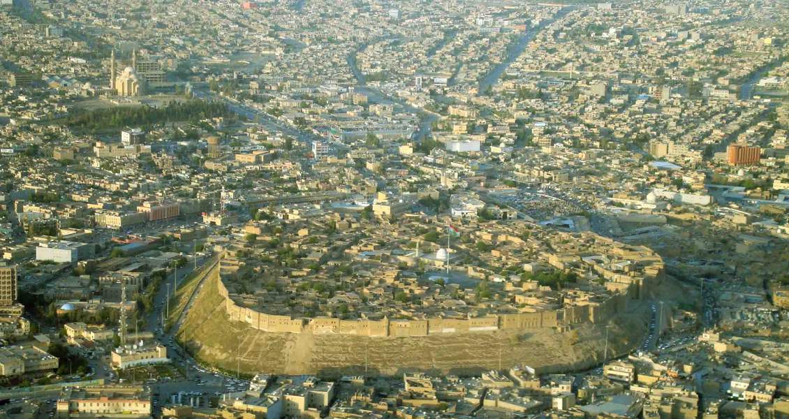
Geologically, Erbil is located on a vast plain between two longitudinal folds within the Tertiary Folded Belt. The plain is covered by basal Pleistocene detritus, primarily polygenetic synclinal fill deposits, consisting of a heterogeneous collection of sediments including debris flow and braided river deposits, reaching a thickness of over 120m. In the centre of that plain lies an almost circular hill, on the top of which is Erbil Citadel, the historic city centre of Erbil.
The hill is about 30m high, with slopes at an angle of about 45°, and is usually described as a tell or occupied mound of manmade origin, but it is actually composed of stacked polygenetic synclinal fill deposits. It is the result of vertical uplift and erosion, followed by human activity over many millennia, which eventually carved away the soft sediment surrounding the more consolidated material of the core.
Successive building throughout human history means that the Citadel is now a magnificent feature that dominates the city of Erbil, the continuous wall of tall 19th-century façades still conveying the visual impression of an impregnable fortress. These are not, however, fortified walls, but a ring of houses built on the edge of the mound and held in place by a series of buttresses. Although Erbil boasts such a long history of human habitation, the oldest house in the Citadel can only be dated back to 1893.
Erbil from the Air (Source: Hawler Gov)
Renovation and Rejuvenation
The Citadel is roughly oval in shape, covering an area roughly 430m by 340m (102,000m2), with three ramps leading up to gates in the outer ring of houses. An inventory made in 1920 identified 506 housing plots in the Citadel, divided east to west into three districts: one for high class families, one for craftsmen and farmers, and one for ‘dervishes’ – Sufi Muslim aesthetes or monks. There were also mosques, schools, a hammam or bath house and, up to the 1950s, a synagogue. Until the opening-up of a main north–south thoroughfare in 1960, the streets on the Citadel mound radiated outward from the southern gate in a fan-like pattern believed to date back to Erbil’s late Ottoman phase.
A lower town had gradually been developing at the foot of the mound, becoming by the middle of the 20th century a more attractive location to live in than the Citadel, so the number of inhabitants living on the mound gradually declined. By 1995 there were only 1,631 inhabitants living in 247 houses left. Finally, in 2007, all bar one of the remaining families in the Citadel were evicted (with compensation) as part of a large project to restore and preserve its historic character; just one family remained, so there would be no break in the millennia-long history of continuous human habitation.
Since 2007 the KRG have been working with UNESCO to preserve and restore the Citadel buildings, most of which are in a poor state, having been predominantly built from mud. Eventually, the hope is to have families living back in the Citadel, making it a thriving metropolitan centre again.
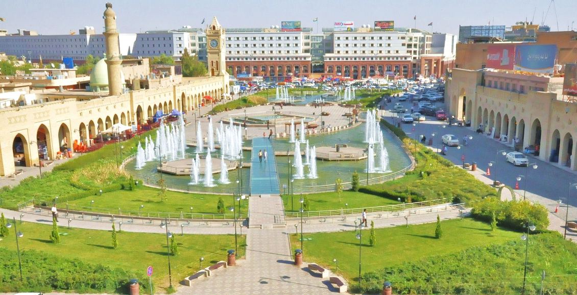
Erbil – a mixture of modern and traditional. (Source: Myararat83/wikipedia)
References:
Mackertich, D and Samarrai, A, 2012. The history of hydrocarbon exploration in Iraqi Kurdistan:1901 to 2012. Petroceltic.
Jassim, S.Z. and Goff, J.C., 2006. Geology of Iraq. Dolin, Prague and Moravan Museum, Brno (Chech Republic), pp.341.
http://en.wikipedia.org/wiki/Erbil


