Broadband Seismic Technology and Beyond. PART IX: BroadSeis in Production.
There are benefits for field development through the application of both the low and high frequency ends of the BroadSeis bandwidth.
In the previous part in this series on broadband seismic technology (Part VIII) we described how the broad bandwidths delivered by the innovative BroadSeis technology benefit exploration. In this part, the advantages of an extended bandwidth to field development and reservoir characterisation are examined.
The high frequencies provide high resolution near-surface images for geohazard identification and also enable detailed velocity modelling which can provide better deeper images. However, in many respects it is the low frequency end of the spectrum which is more important as these frequencies provide more quantitative and reliable reservoir inversion results, simplified interpretation and clearer facies discrimination.
Improved Illumination
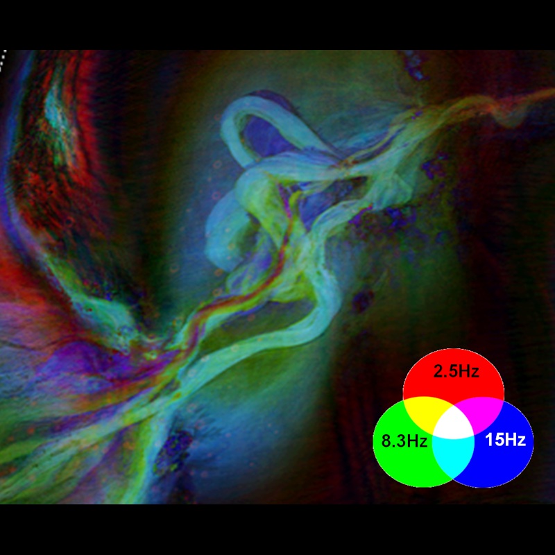 This colour blend 3D visualisation of 2.5 Hz, 8 Hz and 15 Hz dominant frequencies, taken from data obtained in Block 22, Kwanza Basin in Angola, shows the advantages of the wide range of frequencies obtained in a broadband survey. The Upper Miocene channel systems and surrounding salt bodies are highlighted, but without the ultra-low frequencies the red channel would not be visible. (Source: CGG Data Library)In areas with especially complex overburdens, such as the subsalt plays of the Gulf of Mexico, it is recognised that wide-, multi- or – preferably – full azimuth acquisition provides enhanced illumination, as well as improved natural noise and multiple attenuation, in particular when used with ultra-long offsets. Combining this acquisition geometry with the benefits of broadband provides the ultimate seismic data for deep imaging in complex geological areas.
A new technique for efficiently recording full-azimuth towed-streamer data has recently been developed and used to acquire several multi-client surveys in the Gulf of Mexico. This technique uses two multi-streamer vessels, with three additional source vessels, in a patented staggered formation, in order to acquire full azimuth, long-offset data in two orthogonal passes (Mandroux, 2013). The innovative configuration, known as ‘StagSeis’, maintains the advantages of a linear tow as it provides consistent azimuth, fold and offset distribution, and the linear tow means that processing is compatible with conventional wideazimuth techniques. It can also be combined with continuous recording techniques, allowing for longer record lengths by overlapping successive shot records, so that data from the preceding shot are recorded through the water column of the next shot. This allows either denser shot spacing or longer records to be recorded, which is especially useful in deepwater areas.
The StagSeis IBALT (Integrated BroadSeis Acquisition and Long Tow) multi-client survey, in the Keathley Canyon area of the Gulf of Mexico, was acquired with this technique, which was initially developed to address the challenge of illuminating complex geologies where conventional wide-azimuth acquisition fails. In the comparison in the image below the improved continuity of events and greater illumination beneath the salt are clearly visible.
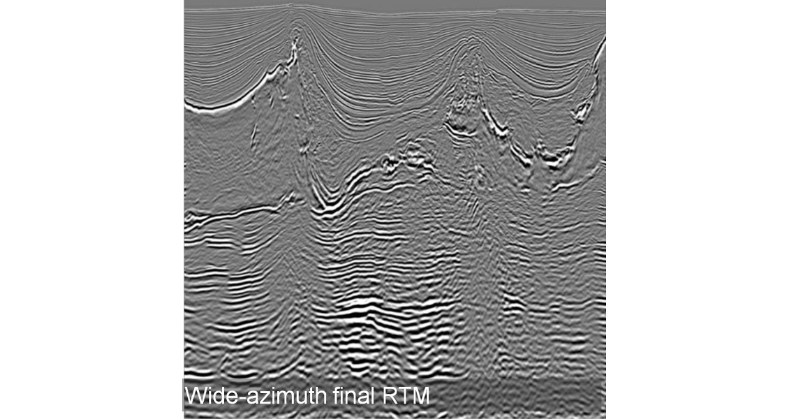
In areas of complex geology, such as subsalt and sub-basalt, illumination is a problem, which can be overcome by the use of full azimuths and long offsets in addition to broad bandwidths. This image from the IBALT survey in the Gulf of Mexico compares data acquired with StagSeis versus conventional wide-azimuth acquisition and shows a staggering improvement in subsalt illumination. (Source: CGG Data Library)
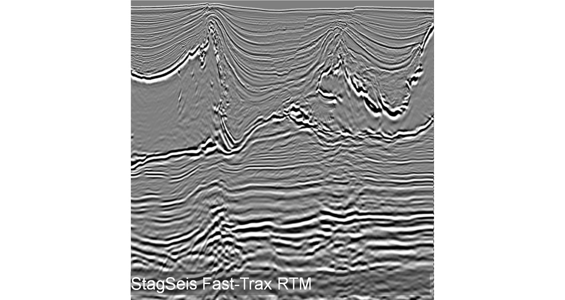
In areas of complex geology, such as subsalt and sub-basalt, illumination is a problem, which can be overcome by the use of full azimuths and long offsets in addition to broad bandwidths. This image from the IBALT survey in the Gulf of Mexico compares data acquired with StagSeis versus conventional wide-azimuth acquisition and shows a staggering improvement in subsalt illumination. (Source: CGG Data Library)
Low Frequencies for FWI
The low frequencies obtained through broadband acquisition are also crucial for Full Waveform Inversion (FWI) of towed-streamer data, a technique which is gaining popularity for velocity model building, as demonstrated in the North Sea by Jupp et al. (2012).
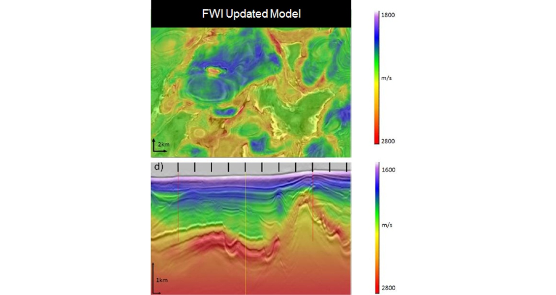
In the IBALT study, combining low frequencies with the full azimuths and long offsets of StagSeis proved ideal for determining the velocities of the complex overburden. This can be seen in the figure below, where a comparison of the FWI updated model using the full-azimuth data with the initial model after three iterations of tomographic updates clearly demonstrates spectacular correlation between the velocity after FWI and the migrated image (Mothi, 2013). The success of the initial IBALT study has led to the commencement of two major extensions of the survey.
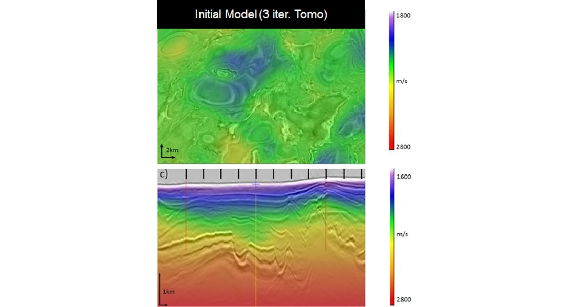
This example from the StagSeis IBALT survey demonstrates that BroadSeis ultralow frequencies are ideal for FWI to deliver accurate velocity models. (Source: CGG Data Library)
This example from the StagSeis IBALT survey demonstrates that BroadSeis ultralow frequencies are ideal for FWI to deliver accurate velocity models. (Source: CGG Data Library)
The flexibility of this staggered acquisition geometry makes it ideally suited to other complex geological settings. It is already being considered offshore Brazil and Angola and is being evaluated, using shorter offsets, for the challenging geology of the Red Sea.
Filling the Gap
Broadband data provide significant benefits for seismic inversion workflows, especially in terms of low-frequency bandwidth extension. The lack of low frequencies in conventional seismic data means that a low-frequency model must be incorporated in the inversion process in order to recover absolute impedance values. Usually, this low-frequency information is obtained by interpolating low-passed filtered impedance logs between well locations, using interpreted horizons as a guide. If the wells are sparse and the geology complex, the low-frequency model derived from the wells may be inaccurate and tends to yield results that are biased towards the initial model.
NMO-derived seismic velocities are often used to define the initial low frequency model, which provides information at the very low frequency range, from ~0 Hz to 4 Hz, while conventional seismic covers the frequencies from around 10 Hz and upward, meaning that the frequencies in the range of 4–10 Hz are missing. The ultra-low frequencies provided by BroadSeis fill in this gap, enabling inversion to be performed using only the seismic velocities, without needing a log-derived low-frequency model, to yield accurate impedance and Vp/Vs estimates, even where there is little or no available well data.
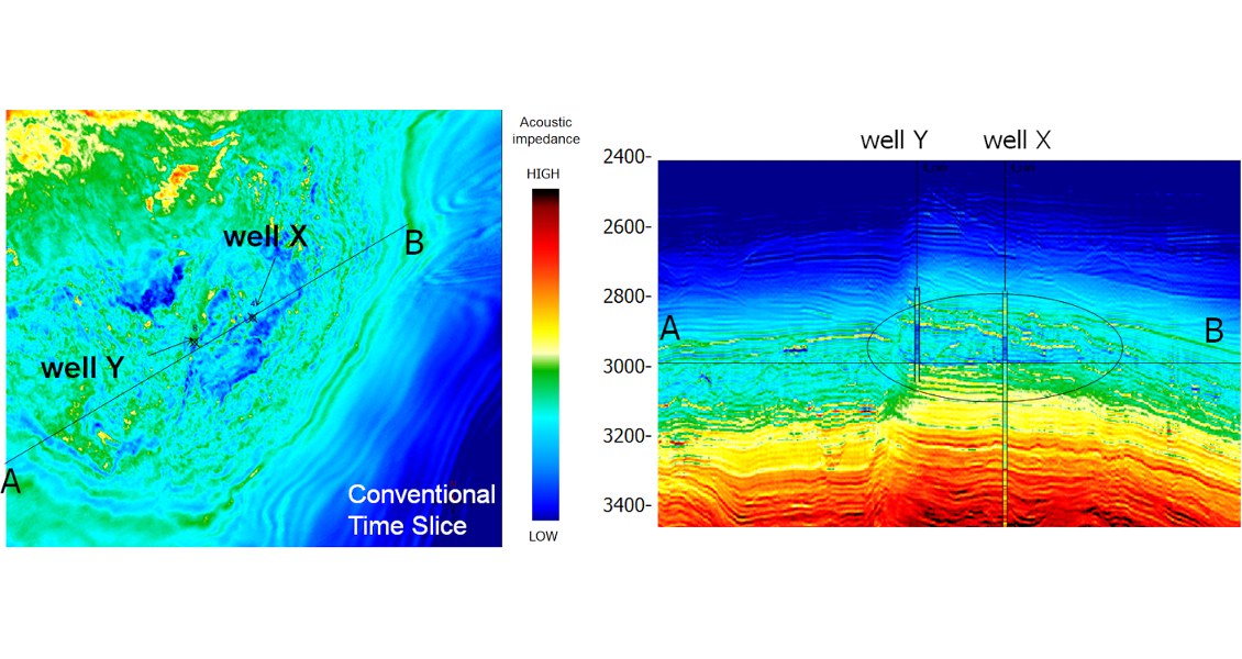
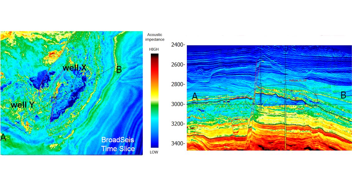
In this post-stack acoustic inversion of data obtained in Brazil’s Santos Basin, the BroadSeis inversion shows greater dynamic range, more realistic correlation with geology and a better match with the blind well (Y). There is a clear wedge visible on the BroadSeis data. (Source: CGG Data Library)
In this post-stack acoustic inversion of data obtained in Brazil’s Santos Basin, the BroadSeis inversion shows greater dynamic range, more realistic correlation with geology and a better match with the blind well (Y). There is a clear wedge visible on the BroadSeis data. (Source: CGG Data Library)
In the example shown above, the inversion was performed using a model based on Well X and the seismic velocity information; Well Y was used as a blind test to validate the results after inversion had been performed (Kneller, 2013). The extended bandwidth provided significantly improved and more geologically realistic inversion results over the conventional data, with greater dynamic range, and clearly defined faults as well as a much better tie to the blind Well Y.
On the other side of the Atlantic, in the Kwanza Basin offshore Angola, turbidite channels and good-quality reservoir sands can potentially be trapped around or beneath salt-related structures, so it is important to track these channels accurately. Broadband seismic data brings a new level of understanding to the mapping of these facies, as by using the full spectrum of frequencies (from 2.5 Hz to 125 Hz) it is easy to highlight greater details of the turbidite facies distribution. The image at the top of this page shows an example of 3D frequency decomposition and colour blend from the Block 22 Kwanza Basin broadband dataset, where a turbidite channel complex is clearly visible, with various phases of sediment fill, meander growth and incisions. Without the ultralow frequencies this picture would be incomplete as the channel highlighted in red would not be discernable. This kind of information is key to tracking reservoir sands around potential traps provided by salt structures, ultimately potentially aiding the discovery of further oil reserves in West Africa.
Better Models and Plans
Broadband seismic is increasingly proving its value at all stages of the exploration and production cycle. The broad bandwidth, including low-noise low frequencies, provides wavelets without sidelobes so that events become single peaks or troughs, corresponding to genuine geological layers and are closer to the genuine seismic signature of formation interfaces. This clarifies impedance contrasts to create sharp images of small features and clear differentiation between sedimentary packages for accurate delineation of the reservoir. Ultra-low frequencies deliver more detailed facies discrimination, more quantitative seismic inversion results and therefore more reliable lithology predictions away from existing wells. This leads to more accurate reservoir models and better development plans. Once production is under way the benefits of broadband for 3D surveys are extended into 4D monitoring to provide better dynamic reservoir models to maximise hydrocarbon recovery.