The Search for Oil in the South-Eastern Barents Sea
Broadband imaging improves the understanding of a prospective area on the Finnmark platform.
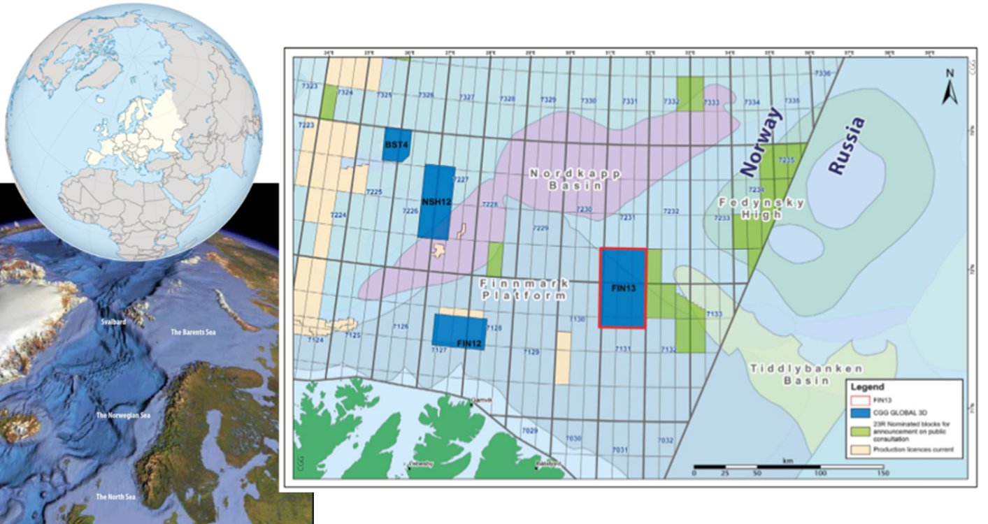
For more than 40 years Russia and Norway were in dispute over a 175,000 km2 area in the Barents Sea. On 15 September 2010 the foreign ministers of the two nations signed an agreement on where the offshore border between their countries should be drawn in the Arctic. During the spring of 2011 the agreement was ratified by the two parliaments and took effect from 7 July 2011.
 The ratification led to the opening of new areas for exploration on both sides of the border between Norway and Russia and several licences have already been awarded on the Russian side. Industry interest in participating in exploration on the Norwegian side is also significant, and the area is targeted for Norway’s 23rd licensing round.
Where its at.
In the 2011/2012 seasons the Norwegian Petroleum Directorate (NPD) acquired a regular grid of modern 2D seismic data to complement the modest amount of vintage 2D data available at that time. In 2013 CGG acquired a large 3D seismic survey, FIN13, west of the former disputed area, covering the northern part of the Finnmark Platform and the western extension of the Tiddlybank Basin. This new survey was acquired with CGG’s proprietary BroadSeis™ technology to produce broader bandwidths and deliver sharper wavelets without sidelobes. These provide more detailed imaging, allowing better identification of prospects and leads.
Structural Setting
The Timanian Orogeny centred in the Russian Barents Sea and the Pechora Basin had a major influence on the configuration of the eastern Finnmark Platform basement (Roberts and Siedlecka, 2002). The area experienced three major rifting events during the Late Palaeozoic, Middle Jurassic, Early Cretaceous and Early Tertiary (Faleide et al., 1993). The new seismic data reveal rotated fault blocks in the Devonian/Carboniferous with a north-west oriented depression in the northernmost part of the Finnmark Platform. These depressions define the basin outline and hence the basin geometry, confirming it to be a northwestwards extension of the Tiddlybank Basin. The rifting phase in the Triassic caused a north-west to south-east trending fault zone to develop.
Multisource Province
FIN13 is situated in an area where both local and long distance hydrocarbon migration scenarios are possible. The south-eastern Barents Sea is considered to be prospective, but resources estimated are modest and generally dominated by gas (NPD publications). The source rock potential for both the long-distance and local migration is expected to range in age from Triassic to Devonian.
Several wells have been drilled in the eastern part of the Barents Sea and well results prove the area to be a multisource province with both oil and gas potential. The oil potential is thought to be significantly higher in the southern part of the area and possibly in the eastern extension of the Tiddlybank Basin, which may serve as a potential migration route for hydrocarbons into the study area and into the Finnmark Platform in general. In addition to the Tiddlybank Basin, the Nordkapp Basin is also considered as a possible source area for long-distance migration. Wells drilled on the Finnmark Platform confirm the presence of oil in Permian carbonates where the Carboniferous Tettegras Formation is most likely to be the source rock. This emphasises the importance of understanding the play models at all depths.
Play Models
Four play models have been identified within the survey area. The play models are located within the Palaeozoic and Mesozoic sections. They represent various depositional settings. A geo seismic profile through the survey displays potential levels of prospectivity. From this, one can see that faults are trending through all prospective levels, and might serve as structural traps. Stratigraphic traps are also present at each level.
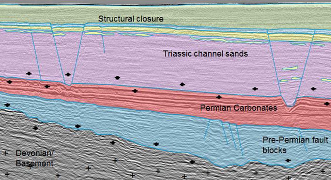
Geoseismic profile showing all levels of potential prospectivity within the FIN13 survey. (Source: Image courtesy of CGG Data Library)
Four-way closure and graben area
A four-way closure with a possible extent of up to 200km2 defines the first play model. The closure is limited by a north-west to south-east oriented graben, formed prior to, or in, the Early Triassic. Potential reservoir rocks from the Early Triassic Snadd Formation to the Early Jurassic Stø Formation are identified within the structural closure and multiple targets are also observed within the area.
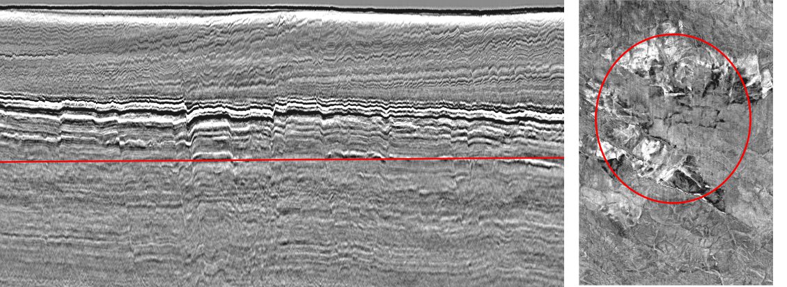
Time slice through Carnian sand bodies, inside graben area and four-way closure. (Source: Image courtesy of CGG Data Library)
Triassic channel sands
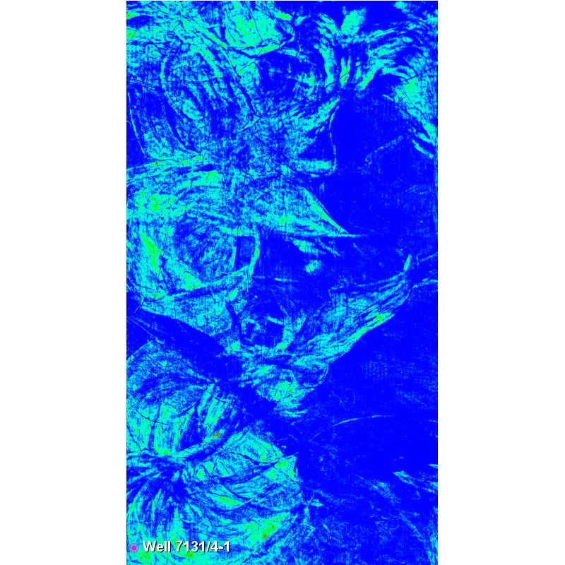 Amplitude map of the Carnian channel sands in Snadd. The light blue colour represents high amplitudes, indicating sand-rich depositions. (Source: CGG)Triassic fluvial sands were observed in well 7131/4-1 in the southernmost part of the 3D survey area and channels with this sand appear as amplitude anomalies on the seismic. This play represents both structural and stratigraphic traps. Anomalies deeper in the Triassic section may represent similar channel deposits.
The Carnian sandstone in the Snadd Formation is expected to have the best potential as a reservoir unit. The characteristic meandering pattern of the Carnian sand has been mapped throughout the whole study area and what are believed to be the most sand-rich facies are easily identified as high-amplitude events. The amplitude signature around the tie-in well is similar to that which we see throughout the survey. Based on the result of the core analysis from well 7131/4-1, one might expect good reservoir sandstone throughout the survey area.
Permian carbonates
Reservoir potential is also present in the Palaeozoic carbonates, which can be observed as a north-west to south-east trending belt in the southern most part of the survey. Time-slices through the Palaeozoic section at the Finnmark Platform indicate an ex tensive karstification of the carbonates. As demonstrated by the Gohta well in the western Barents Sea, karstification is one of the crucial processes enhancing the reservoir quality of carbonate reservoirs in the Barents Sea. In the FIN13 survey area, the karstification is seen as dissolution features at several depths, ranging from the top of the warm-water carbonates of the Gipsdalen Group to the top of the cold-water carbon ates of the Late Permian Røye and Ørret Formations.
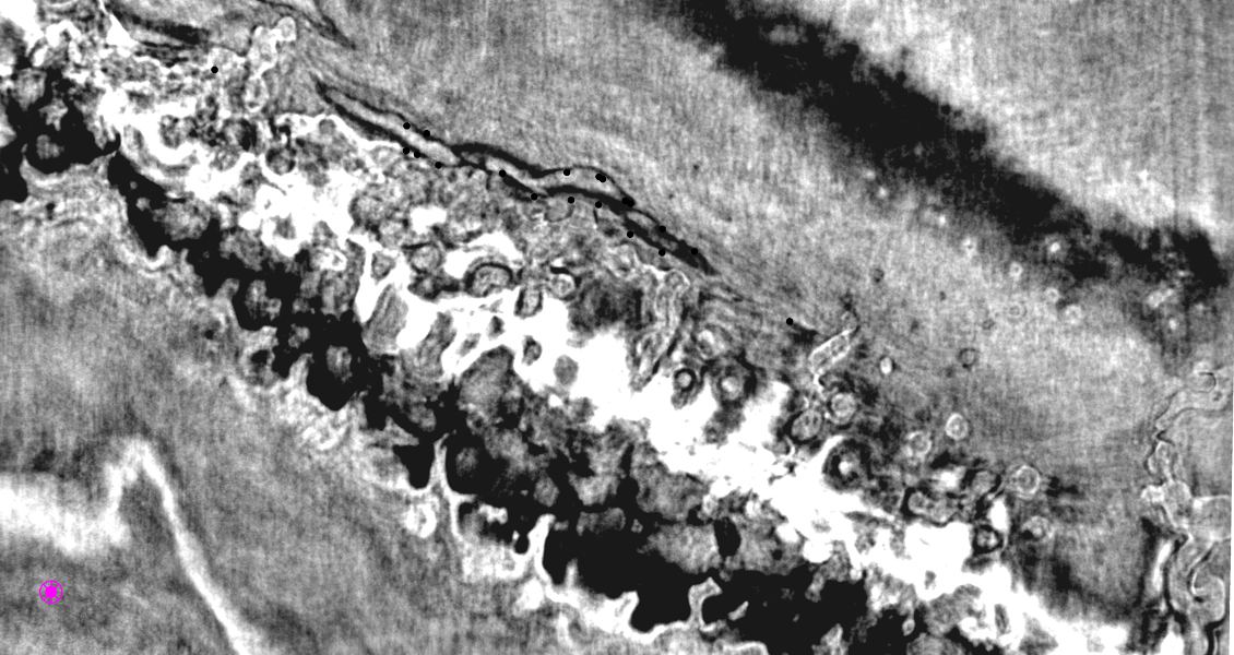
Time slice through the Permian carbonates, with an indication of karstification. (Source: CGG)
Rotated fault blocks in Pre-Permian
Rotated fault blocks formed during the rifting phase in the Late Palaeozoic, controlled by earlier-created zones of weakness. The rift system is seen as grabens and halfgrabens in the Carboniferous to Early Permian, forming potential traps for hydrocarbons. Wells drilled on the Finnmark Platform and in the Timan Pechora region have oil and oil shows in Upper Permian carbonates, sourced from the Devonian. This may also be the case within the study area. In addition to serving as potential reservoir sections, the rotated fault blocks may also serve as kitchen areas in the deepest parts of the basin.
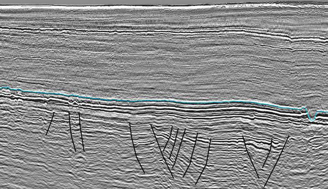
Rotated fault blocks in the Pre-Permian. Blue horizon is interpreted as Top Permian (fast-track data). (Source: Image courtesy of CGG Data Library)
Geochemical Sampling Confirmation
Although only fast-track data is available, there are few indications of gas in the data and this supports the model of a petroleum system dominated by liquids rather than gas. In 2014 CGG acquired a large surface geochemical sampling programme covering most of the southeastern Barents Sea. The results from this programme will reveal additional information about the petroleum system and, it is hoped, confirm the liquid petroleum potential in the south-eastern Barents Sea.