Completing the Picture
Enhancing the understanding of the Barents Sea with full-tensor-gravity gradiometry.
The Barents Sea represents one of the largest areas of continental shelf on the globe and is a structurally complex region, composed of platform and basinal areas. The Barents Sea is surrounded by a series of known hydrocarbon basins, such as the North Sea, Sverdrup Basin, the North Slope of Alaska, the Western Siberian Basin and the Timan-Pechora Basin and hence is an obvious target for extensive exploration.
Since 2011, after the treaty between Norway and Russia on the maritime delimitation of the Barents Sea and Artic Ocean was agreed, the South Eastern Barents Sea frontier area has opened up for hydrocarbon exploration. The Norwegian Petroleum Directorate (NPD) has acquired a large scale multi-client 2D seismic dataset over the entire 44,000 km2 of newly opened acreage. There are also plans in the pipeline for targeted 3D seismic surveys over nominated blocks that are currently being acquired and due to be completed mid-2015, shortly before the licence round bids are due to be submitted. Multi-client seismic surveys are an established tool in frontier exploration and for supporting licence rounds. Full-tensor gravity gradiometry (FTG) surveys are now also being offered under a multi-client business model, and are having a significant impact.
The structural complexity and sheer size of the Barents Sea lends itself to an FTG survey, both for a regional understanding and for several specific geological environments where FTG would provide uplift to the pre-existing and planned seismic surveys and interpretations. To this aim, ARKeX are currently acquiring a 42,784 km2 multi-client FTG survey over the entire South Eastern Barents Sea that will be fully processed and ready for delivery in August 2014.
What is FTG?
FTG measures the spatial rate of change of the Earth’s gravitational acceleration in response to small variations in subsurface density. An FTG dataset can essentially be thought of as a high resolution, broad bandwidth gravity survey that also benefits from a high signal-to-noise ratio at the majority of wavelengths when compared to conventional gravity when acquired from a moving platform.
Integrated Gravity Measurement Assembly (GMA) data is acquired and processed simultaneously, which provides explorers with a high quality conventional gravity product. This is used in conjunction with the FTG data as it provides a slightly better signal-to-noise ratio (SNR) at very long wavelengths when compared to FTG. ARKeX utilises the best of both signals, combined with advanced processing techniques to provide the very best data fidelity at all frequencies.
FTG and GMA data is best when integrated with other geophysical datasets, particularly seismic. Typically, where seismic data encounters illumination difficulties, FTG data often benefits from favourable geology where lateral density contrast is evident. This includes scenarios containing carbonates, salt, volcanics and highly structured and/or heterogeneous basements. Similarly, the interpretation of FTG data benefits from integration with seismic, which provides vertical constraint to what would otherwise be a non-unique solution. This is also true of well data.
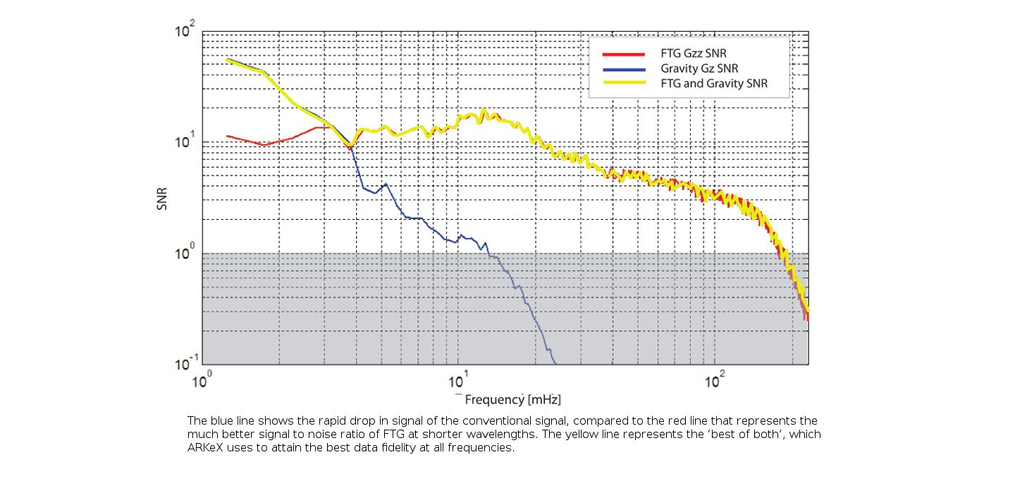 Graphic representation of the signal to noise ratio of conventional airborne gravity and FTG.FTG surveys are very coste ffective and benefit from fast acquisition and processing rates. This enables explorers to acquire a high quality 3D dataset over large areas prior to making exploration and bidding decisions. FTG can be acquired on an airborne or marine platform and is a passive system, making it a safe and environmentally discreet geophysical survey.
Barents Sea Geology
 The ARKeX FTG survey covers five distinct structural highlights: the Finnmark and Bjarmeland Platforms, the Nordkapp and Tiddlybanken Basins and the Fedynsky High, all of which represent hydrocarbon exploration opportunities. The structural elements of the region are also labelled.The Barents Sea has two major deepseated structural trends as a result of two continental collision events, which dominate the tectonic fabric of the region. The first trend formed during the Caledonian Orogeny when the collision of the Laurention and Baltic plates closed the Iapetus Ocean. The second collision was between the Laurasian continent and Western Siberia, during the Uralian Orogeny. These deep structural trends have a profound influence on the basement structures within the region and on the more recent development and structure of the overlying basins and platforms.
The two dominant structural fabrics of the region can be seen in the north-east to south-west trend of the Nordkapp Basin, as a result of the Caledonian Orogeny, and the north-west to south-east trend of the Tiddlybanken Basin, as a result of the Uralian Orogeny. These basins are surrounded by the three structural highs with the Bjarmeland Platform to the north, the Finnmark Platform to the south and the Fedynsky High in the east. The fact that two major structural trends appear within a relatively confined area suggests that the complexity of the region is significant here.
The overburden within the Barents Sea is relatively thin due to the region having been through an extensive period of uplift during the Cenozoic, which removed the majority of the Cretaceous and Paleogene and had a profound effect on any potential hydrocarbon accumulations. Implications include whether the play is oil or gas, the quality of the main Jurassic reservoirs, and the possibility of once oil-filled reservoirs being empty because of spillage due to tilting, seal leakage or exsolution of gas, forcing the oil from the traps.
Due to the complexity of the area, it is extremely important for the explorer to understand the deep-lying structural geology as well as the shallower target levels to fully define and de-risk the plays. The tectonic history of the region will play an important part in predicting the hydrocarbon type, reservoir quality and trap integrity. FTG, alongside conventional gravity and seismic data, allows the explorer to shed light on tough geological and geophysical environments both at significant depth and in the relative shallow, for an enhanced regional understanding and down to prospect scale.
FTG Advantages
Salt Definition: The South Eastern Barents Sea contains two salt basins, Nordkapp and Tiddlybanken, which are the most obvious areas for utilising an FTG survey as the salt structures can be delineated clearly and salt volume constrained. The large, sub-vertical, diapiric salt structures in the Barents Sea are relatively shallow, often reaching the sea bed. The large density contrast between the salt and surrounding sediments, along with the shallow salt dome depths, allow the salt flanks to be defined extremely accurately using FTG data, resulting in enhanced seismic interpretations.
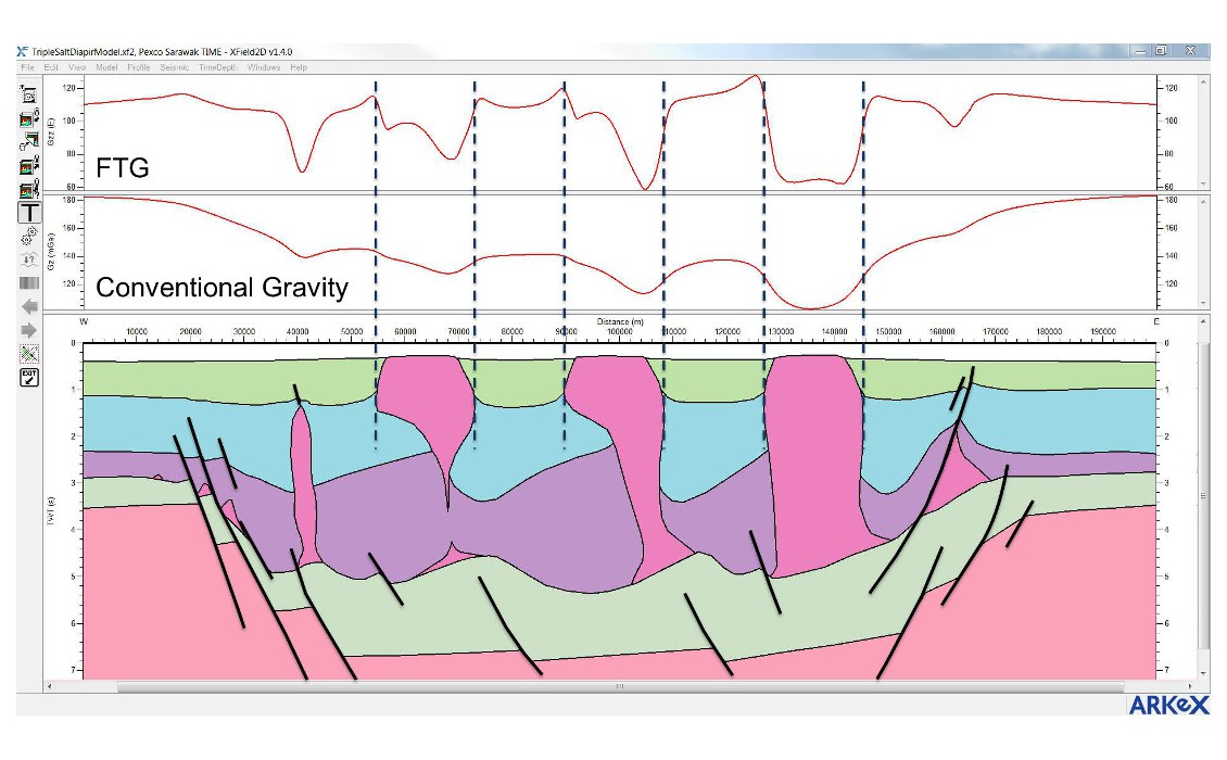
Schematic 2D cross-section, designed to reflect three possible salt interpretations of a seismic section through the Nordkapp Basin. The change in salt volume has a significant impact on the FTG signal amplitude, including over asymmetric diapirs. The edges of the salt are easily delineated and this will be extrapolated into 3D.
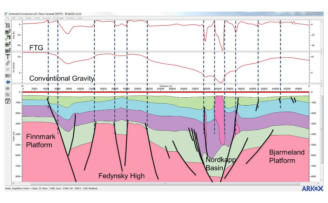
Surmised cross-section of the different structural elements that will be seen in the Barents Sea FTG survey. The salt, as before, is clearly seen, as are the basement highs in the Fedynsky High. The Tiddlybanken Basin will show a similar profile as the Nordkapp example and the shallow faulting in the Bjarmeland Platform is also well imaged.
Previous interpretations of seismic in the Nordkapp and Tiddlybanken Basins have typically included a very large volume of salt. This interpretation has a large potential for error, due to salt illumination problems in seismic data, but nevertheless it has limited the prospectivity of the basins and in particular the salt plays themselves. Using FTG and GMA data, the volume of salt can be constrained better, with necking, overhangs and detached salt bodies being imaged and interpreted far more confidently than with seismic alone. Refining the salt bodies in the Nordkapp and Tiddlybanken Basins could potentially open the acreage up for new salt plays.
FTG and conventional gravity datasets are also used for sub-salt interpretation where previously unknown basement structure can be resolved. Once the salt bodies have been accurately modelled using the FTG data, the resultant longwavelength residual signal must originate from deeper structural bodies, most likely the basement.
A further result of improved salt body definition is the potential for providing a better velocity model around and below the salt structures, which allows for subsequent enhanced seismic processing and, therefore, imaging.
Sub-Carbonate Illumination: The Barents Sea contains extensive Permian carbonates that appear to extend over the entire area. As seismic data often has illumination problems sub-carbonate, this provides another opportunity for an FTG dataset to contribute to the structural modelling of the region.
Similar to sub-salt imaging, despite the often high density nature of carbonates, FTG will pick up the signal from the deeper lying structural variation as well as the shallower carbonate structures. This is particularly useful in the structural high areas in the Barents Sea, such as the Finnmark and Bjarmeland Platforms and Fedynsky High, where accurately modelling the basement and overburden structure is the primary geological question.
Basement Modelling, Overburden and Seismic 2D/3D Extrapolation: In the platform areas of the South Eastern Barents Sea, as well as the Fedynsky High, previous exploration of relatively shallow structures in the Permian Carbonates and Lower Carboniferous sandstones has reported residual oil shows. There is also potential in Upper Jurassic sandstones immediately below the Base Cretaceous Unconformity, where there are potential flat spots and gas leakage.
The South Eastern Barents Sea has very good 2D seismic coverage and the 3D seismic surveys currently being acquired will cover large areas of the newly opened acreage. This seismic data is, and will be, an excellent tool for interpreting faults in the shallow section. As described above, FTG and GMA data can help image features where seismic struggles, but it is also an excellent tool for linking together 2D seismic interpretations and/or 3D seismic models by extrapolation and interpolation.
The multi-client 2D seismic survey has a line spacing of approximately 5 km over the majority of the region and the combined 3D surveys will cover about 13,700 km2 over an area of roughly 44,000 km2. Shallow faulting, interpreted only using seismic datasets, can be linked by simple extrapolation along a straight line to the next interpreted line. In reality, faults are rarely straight lines and FTG data can be used to provide a full 3D fault answer, interpolating between lines and surveys to more accurately reflect the geology. This is not only important for better modelling of the faults and shallow structures and targets, but in forming a more complete understanding of the regional structural framework, ensuring the correct trends are being picked.
Similarly, the basement structure can be modelled between 2D seismic lines and 3D surveys. Some of the blocks recently announced are located on the faulted flanks of the Nordkapp and Tiddlybanken Basins. FTG, along with conventional gravity datasets, is a powerful tool for creating comprehensive structural models in areas of basement faulting, where the basement/sedimentary fill interface provides an excellent density contrast and target for FTG data.
Exciting Frontier Region
The newly opened acreage in the Barents Sea is an exciting frontier region, in a generally well known region of the globe. Prior to the submission of licence round bids, companies are generating an understanding of the tectonic history of the region, building structural models, and generating play and prospect opportunities using multiclient datasets. Key to this is seismic interpretation through the pre-existing 2D data and the future 3D surveys; however, it is also clear that ARKeX’s multi-client FTG survey also adds a significant amount of information and clarity to this geologically complex region and in a timely fashion.
Whilst FTG technology is still relatively under-utilised, there is a rapidly growing list of oil companies that have come to recognise the value of the technology at all phases of the exploration cycle. FTG is a powerful tool in almost any geological environment, but also represents a cost-effective way of covering vast areas of the globe in a much reduced timeframe compared to seismic. ARKeX’s Barents Sea survey will provide an enhanced 3D understanding of the region, whilst also being available almost a year before the official bid round applications are submitted, allowing explorers to make a significantly more informed decision.
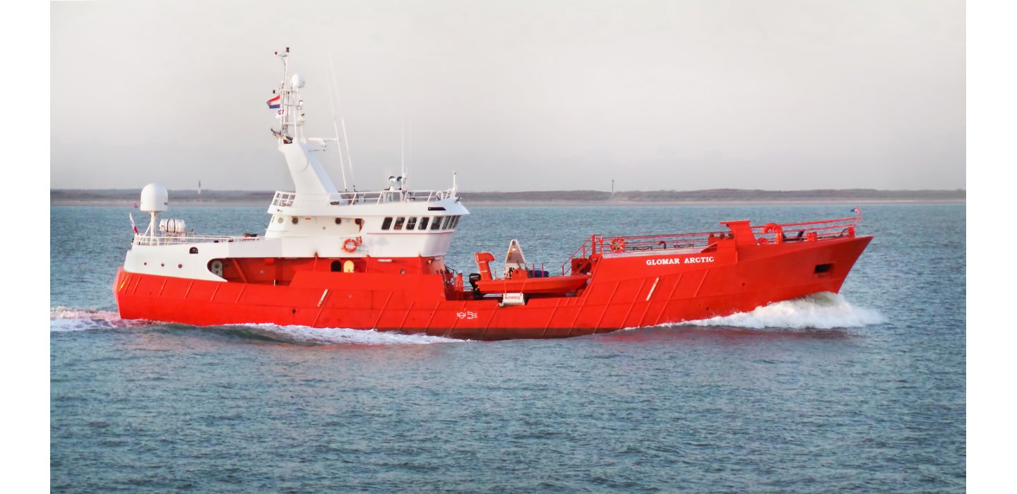 The Glomar Arctic was used for the FTG surveys in the Barents Sea.