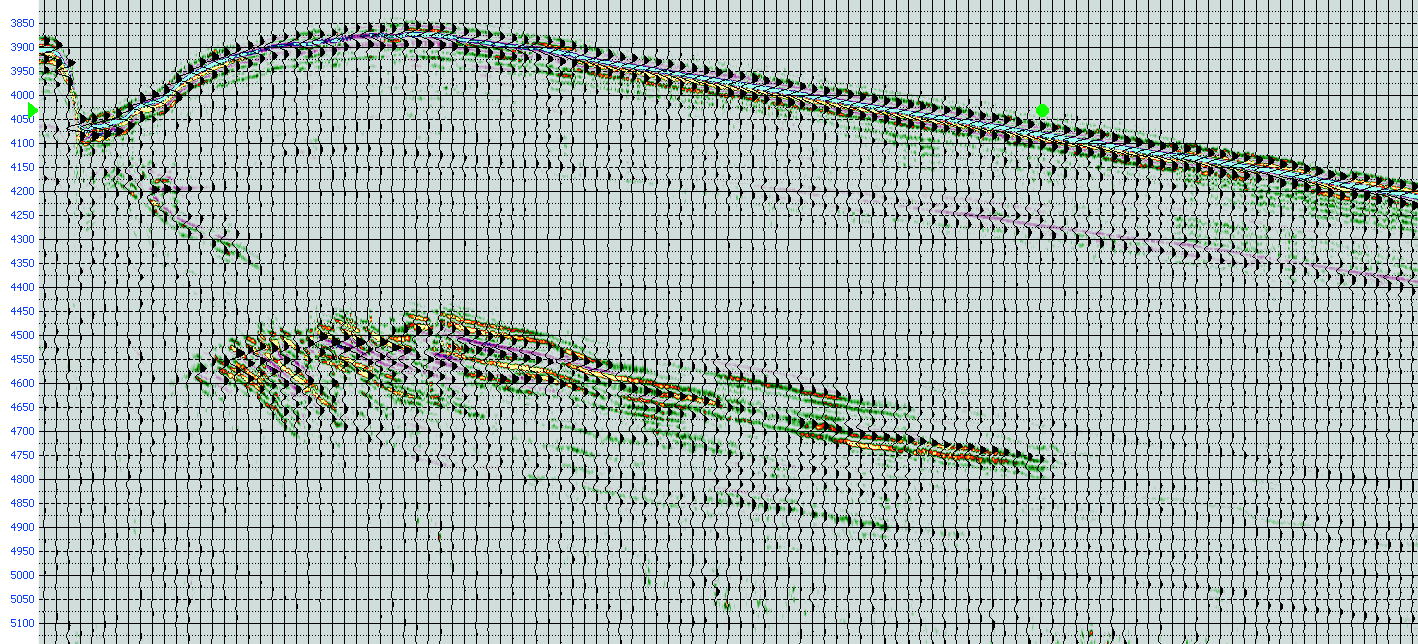
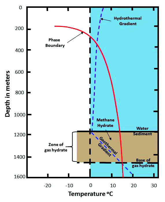
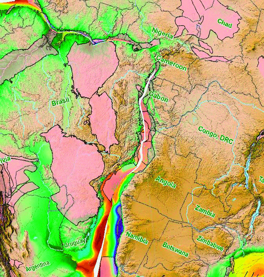
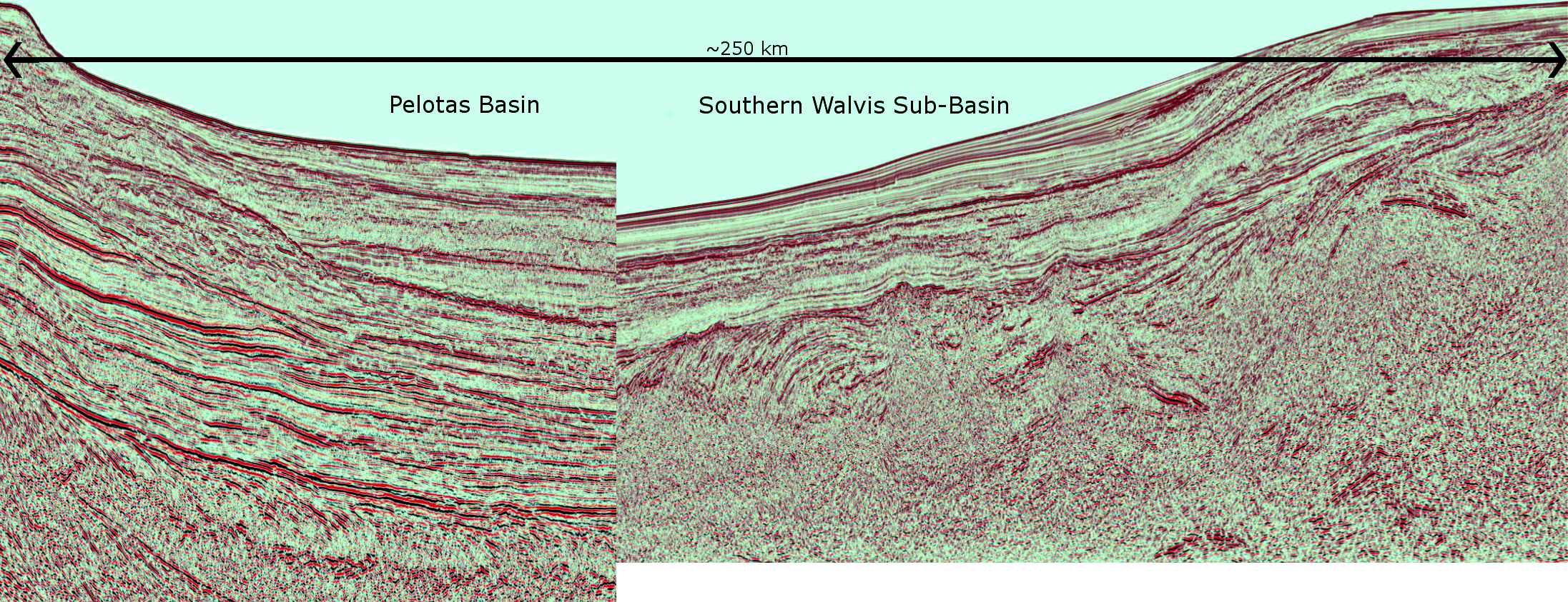
Whilst the white heat of sub-salt exploration in the Santos and Campos Basins of Brazil’s Atlantic Margin has yielded extraordinary success, its southern sister, the Pelotas Basin, has seen little attention for over ten years, despite displaying clear direct hydrocarbon indicators. However, a new 2D seismic program acquired in 2013 is revealing new evidence for sand-rich systems and oil plays, making the deepwater Pelotas Basin an excellent choice for blocks to be nominated in Brazil’s upcoming Bid Round 13. To see the full seismic lines please download our PDF for the print issue available through this link: GEO ExPro Vol. 10 No. 4 Potential for large oil plays is refocusing the attention of E&P companies in the Pelotas Basin. The Pelotas Basin is an untapped hydrocarbon province comprising a 280,000 km2 passive margin located on the south-east coast of Brazil, bordering Uruguay to the south. Up to 7,000m thickness of Cretaceous and Tertiary post-rift clastics have been deposited in the basin, including both Paleocene and Albian source rocks. These source rocks are actively generating hydrocarbons today and there are seismic indications of an active, working petroleum system similar in character to those found in the Niger Delta in West Africa. Recent high quality 2D seismic data has imaged multiple potential reservoirs, traps, source rocks and direct hydrocarbon indicators in the basin. The new seismic data show that since the inception of rifting between South America and Africa (at 125 Ma), the mouths of paleo tributaries of the Rio de la Plata moved along the margin several times. The most recent depocenter comprises a four kilometer thick Tertiary clastic sequence which displays a world-class direct hydrocarbon indicator in the form of a 40,000 km2 sheet of Bottom Simulating Reflectors (BSR), which are confined inside the 3,000m Tertiary isopach. The Tertiary delta has prograded over, and matured, a Paleocene source rock, and gas and condensate from this source rock subsequently migrated up through the prism via abundant gas chimneys and plumes, to be trapped by the gas-water crystal phase change creating the BSR. Additionally, numerous oil seeps detected by Synthetic Aperture Radar and standard satellite imagery in the southern Pelotas Basin appear to define a linear feature, approximately coincident with the 500–800m isobaths. This suggests that oil, generated at depth below the Tertiary prism, is migrating up to the impermeable solid base of the hydrate until it reaches the up-dip extent of the BSR (ca. the 500–800m isobath). This oil is also trapped by stratigraphy or structure below the BSR, creating a shallow oil play within the Tertiary prism itself. Preliminary AVO analysis indicates large accumulations of free hydrocarbons are trapped in porous intervals below the solid hydrate layer. Despite the abundant gas in these sequences it is the potential for large oil plays which is refocusing the attention of E&P companies in the Pelotas Basin. The BSR represents the base of a solid layer of gas hydrates, comprising water molecules that form cages containing methane (CH4), ethane (C2H6) and propane (C3H8) molecules trapped by high pressure. The pressure and temperature conditions necessary for the formation of hydrate crystals require an environment with water depths greater than 300m. The associated gas hydrates exist from approximately 100m beneath the sea floor to as deep as 450m beneath the sea floor. The conjugate margin rift basins of West Africa and Brazil initially formed by east-west extension initiated during the early Cretaceous, as the South American plate began to separate and rotate clockwise from Africa. When the margins are reconstructed to their respective positions in the Albian it is informative to compare the respective margins for differences and similarities. A reconstruction with today’s sediment thickness, joined where they may have been 125 Ma, shows the asymmetry from the Pelotas Basin to the conjugate Namibe Basin. This occurs because of large differences in the elevation of the terrains supplying a sediment source to each basin, and it is possible to correlate an Apto-Albian sequence from Namibia to Pelotas. In mini-basins directly above the break-up unconformity, planar-bedded high amplitude Apto-Albian marine shales are correlated with units in the Namibe conjugate basin. In Namibia these shales are considered the primary deepwater oil source for the light oil recovered from Wingat-1. Additional source intervals in the Pelotas Basin include syn-rift Cretaceous lacustrine shales (Kudu, Orange River Basin analog), post-rift Apto-Albian, Cenomanian Turonian and Paleocene marine shales. Both the Pelotas and Namibian Basins are underlain by thickened high-density volcanic crust with an abundance of seaward dipping reflectors. Basin subsidence is controlled both by long-term post-rift thermal contraction and differential sediment loading and accommodation. The new seismic data in the area illustrates the Pelotas Basin received substantially more sediment than the Namibe Basin and consequently the basement is deeper. In Pelotas, the prograding Tertiary wedge over the Paleocene source rock triggered a glide-plane detachment within the source rock, similar to the Niger Delta. Structural traps are developed within this gravity-driven structural complex along listric normal faults up-dip, and toe-thrust structures down-dip. The Orange River Basin in Namibia exhibits a similar, though older, feature with a deeper detachment on the Cenomanian-Turonian source rock. Although few wells have penetrated the deepwater section of either margin, the interpretation of the new seismic data suggests deltaic processes generated numerous potential plays. The supply of sediments via shelf and delta to the post-rift thermally subsiding margin was subject to both global sea level change and locally controlled delta lobe switching. The new seismic data in the area indicates much of the potential reservoir was deposited by mechanisms common to many passive margin mixed-source deltaic systems. Thin highstand sands are interpreted from pro grading clastic wedges, in addition to aggradational shelf edge sequences and lowstand slope fan sands. In the Early Cretaceous, however, it appears the pro-delta slope was too steep for deposition of slope fans as these appear to have bypassed the slope and accumulated as thick ponded turbidites on the basin floor, creating a very exciting play above Albian source rock. Additionally through the Upper Cretaceous and Tertiary, overbuilt prograding units appear to have suffered shelf collapse and slope failure in the northern parts of the basin, depositing thick stacked slump sequences on the basin slope and floor. Of the twelve wells drilled in the offshore Pelotas Basin to date, three were effectively stratigraphic probes, seven were drilled on the shelf and two wells tested Tertiary prospects in deeper water, all of which were dry with oil shows. A more detailed examination of the seismic data indicates the deepwater Pelotas Basin contains substantially more prospective targets than the shelf. There is considerable evidence of a working petroleum system with a Paleocene source rock presently within the oil window, and correlation with the conjugate margin provides evidence of source rock in the Albian section which opens up a second deepwater oil play. There are many good reasons to believe that the deepwater Pelotas Basin would make an excellent choice for blocks to be nominated in Brazil’s upcoming Bid Round 13.
The Pelotas Basin oil province revealed
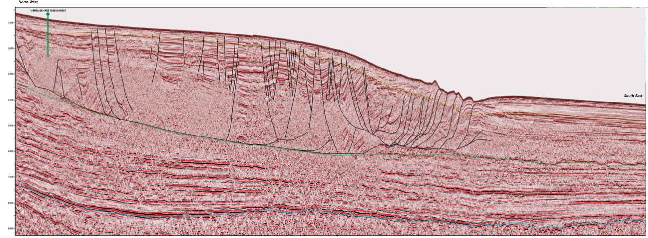 In 2013 Spectrum acquired 7,500 km of 2D seismic data with a 12 km cable and a 13-second record length, and is currently re-processing 10,000 km of legacy 2D data across the Pelotas Basin. Modern pre-stack time and depth processing has imaged structural and stratigraphic features within both the clastic section and volcanic-rich extensional basement.

An untapped hydrocarbon province
Evidence for hydrocarbons
Petroleum system
Exploration opportunities
Related Articles