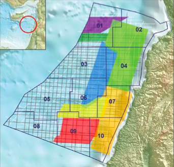
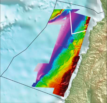
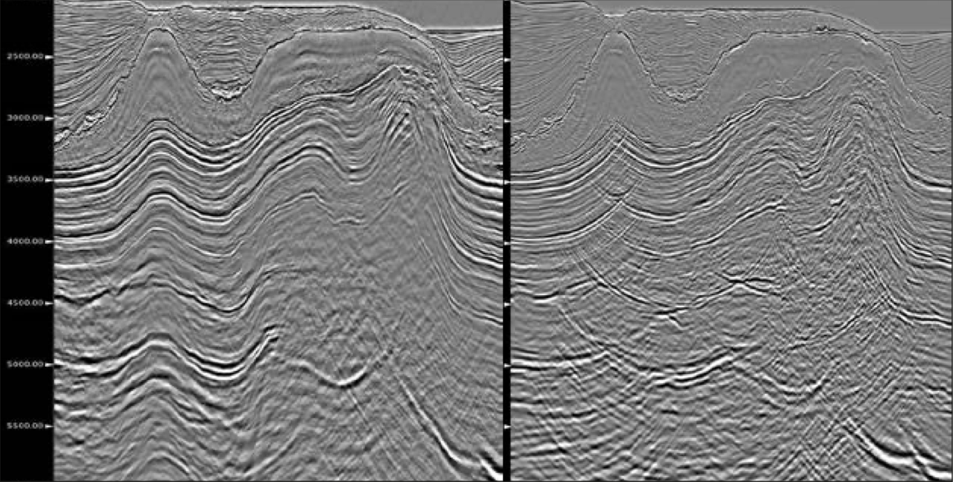
After several years of preparation the first offshore bid round in Lebanon is now open. Petroleum Geo-Services has acquired non-exclusive seismic data covering all the 10 exploration blocks of the 22,730 km2 offshore area. The seamless Lebanon PSDM MegaSurvey, which is providing continuous seismic 3D coverage from north to south, is a powerful tool to understand the petroleum systems and to assess the potential prospects in this region, which will be the next hot spot for oil and gas exploration. The Ministry of Energy and Water of the Republic of Lebanon opened their first bid round on 2 May 2013 with a closing date of 4 November 2013. Twelve companies qualified as operators and 34 as non-operators and bids from consortiums of a minimum of 3 companies are invited. Plays offshore Lebanon are stratigraphic, fault and/or fold related. The geological development of the basin is complex, well data is sparse and the area remains undrilled. However, the exploration blocks offered are covered by MultiClient (MC) seismic data (MC2D and MC3D; see main foldout), enabling a shortened timespan between block awards and exploration drilling. The seismic acquired includes a dense MC2D grid and multiple overlapping MC3D surveys, providing a consistent dataset for regional interpretation. The seven MC3D surveys (total 10,000 km2) were acquired with different acquisition parameters and directions, but the fold of coverage has been optimised at the boundaries and seismic traces borrowed to produce a seamless MC3D MegaSurvey. The older MC3D seismic has been reprocessed using 3D SRME and other modern noise attenuation, to provide consistent high quality data. All MC3D surveys will be available with pre-stack depth migration (PSDM). The continuous MC3D coverage gives a clearer image of the regional structural pattern and allows interpretation of the depositional history of the northern Levant Basin, providing the key to identifying and understanding prospectivity. The individual MC3D surveys contain classic time imaging challenges: lateral velocity changes across faults, salt geometries, shadow zones and sub-salt structures. Water depth ranges from 200m on the margin up to 2,000m in the basin and, excluding the margin, a thick Messinian evaporite is present over most of the area. The MC3D MegaSurvey is therefore delivered with PSDM. Velocity model building used hyperBeam technology and a hybrid velocity model-building workflow enabled the solution of complex velocity variations. The velocity model was built in a top-down fashion with tomography technology allowing construction of a model based on a slant stack of local seismic traces decomposed into wavelets. After solving for background velocity, high-resolution velocity updates were performed to account for rapid spatial variations of salt velocities. Structural updates of key reflectors and tomographic velocity inversion updates, including data masking, were undertaken iteratively. For anisotropy parameters a constant delta and a gradient epsilon function were included. Beam and Kirchhoff migrations were run with the final velocity model producing complementary images. The dipscan process in the Beam PSDM gave a higher signal to noise ratio result than the conventional Kirchhoff PSDM. The Beam has an inherent noise reduction process and relatively clean appearance and is used for a more structural interpretation and the Kirchhoff, with its relatively higher spatial resolution, is used for more detailed interpretation. The structural system offshore Lebanon is dominated by left-lateral strike-slip motion of the Dead Sea Fault System and the north-east to south-west trending restraining bend that produces Mt. Lebanon and the Palmyrides. Features similar to the onshore strike-slip faulting are seen in the offshore seismic. Pliocene to recent faulting originates in the pre-Messinian and is characterised, in shallower intervals, by multiple flower structures resulting in pop-up features, anticlinal structures and occasional small-scale extensional basins exhibiting normal faulting. The north-east to south-west trend of the features is consistent with the expected orientation of transpression in a wrench fault system. Movement along the strike-slip faults results in south-west translation of the thicker and older continental crust outcropping onshore Lebanon toward the Levant Basin, and structurally higher along the margin. Several of the dominant strike-slip faults merge with the north-west to south-east trending, so-called ‘Piano Key’ normal fault system in a manner suggesting that both sets are related to a single strain field created by the restraining bend in the Dead Sea Fault System. The ‘Piano Key’ faults are accommodation tears that formed contemporaneously with the strike-slip faulting and these are post-Messinian events. The Messinian evaporite sequence acts as a buffer between the deeper/older strike-slip/’Piano Key’ fault systems and the overlying Pliocene sediments and younger normal faulting. The Pliocene sediments are translating north-west above the Messinian salt with extensional faulting seen near the margin and compressional folding and faulting observed basinward. Low angle normal detachment faulting within the older Pliocene section provides a timing horizon for the translation and uplift along deeper strike-slip/’Piano Key’ faults. The PSDM MegaSurvey can be used to interpret sediment transport. The main sources of sediment are associated with the Nile and associated fan systems. Northward transport dominates in younger time intervals but during the Late Miocene there are indications of southward directed sediment dispersal in the northern part of the Levant Basin. The Levant Margin probably contributed sediment to the basin consistently but, although important for prospectivity, it is not regarded as a major contributor. Key interpreted horizons provide a stratigraphic framework from Upper Jurassic to present [see main foldout]. The Lower Miocene package, proven as prospective in the southern Levant Basin, has a maximum thickness around southern offshore Lebanon and thins towards the east and north, facing central and northern Lebanon. Information on the geodynamic history is limited but the outline of the package indicates fan-like deposition. Seismic cross sections suggest the presence of individual fans, identified as high-amplitude packages within the Upper and Lower Miocene and fed by systems originating to the south-southwest. Amplitude maps of the uppermost Miocene seismic interval indicate fan systems in the northern Levant Basin. Sediment transport is north-east to south-west, implying sediment sourcing from northern Lebanon and Syria with channelised systems feeding into fan and lobe distributary patterns. Above the Messinian evaporite sequence the sediment pathways return to the south. South-west to north-east trending channels (parallel to the Levant Margin) are interpreted to originate from the south-south-west carrying sediment to the north-north-east and developing a fan system in the north-eastern part of the Levant Basin. These systems probably represent the distal Nile Delta Cone, with sediments from the African Margin transported initially by the Nile. All information about the licensing round can be found on the new official web page of the Lebanese Petroleum Administration: www.lpa.gov.lb The authors would like to thank the Ministry of Energy and Water and the Petroleum Administration of the republic of Lebanon and colleagues in Petroleum Geo-Services for all the work and assistance with the Lebanon data.
Will Lebanon be the next oil province?
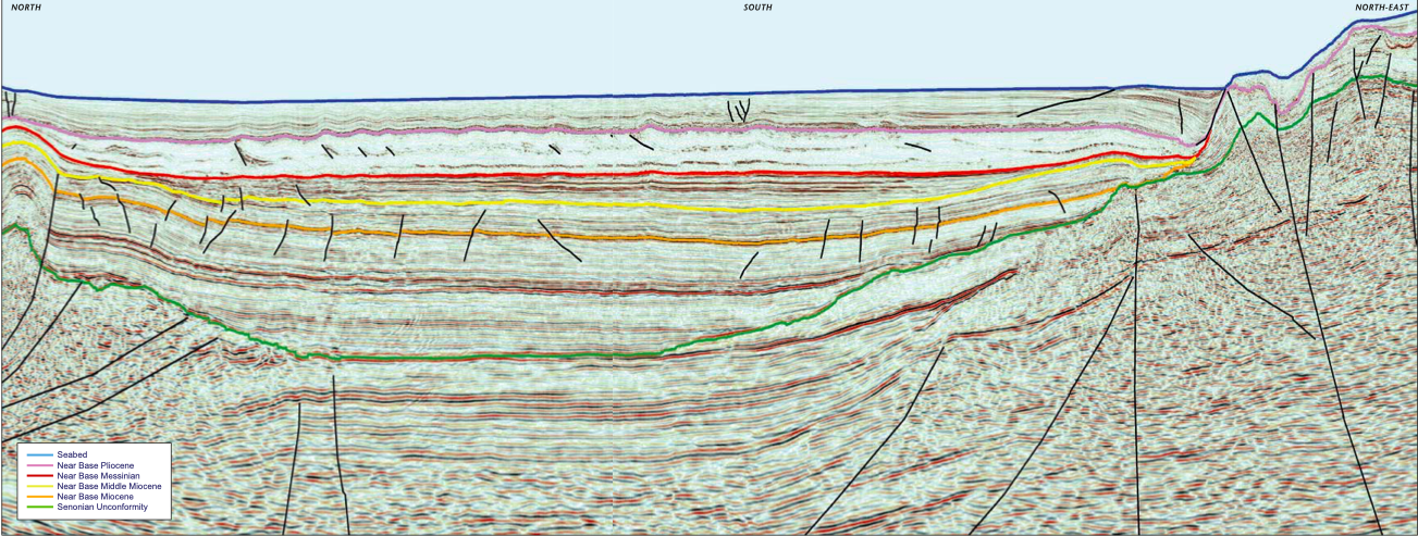 The key regional reflectors have been interpreted on the data and all the MC3D surveys have been merged and re-processed with PSDM imaging. This arbitrary PSTM line example (65 km long) illustrates the variety of different play types offshore Lebanon.
MegaSurvey Key to Understanding Prospectivity
To see the full seismic lines please download our PDF for the print issue available through this link: GEO ExPro Vol. 10 No. 3
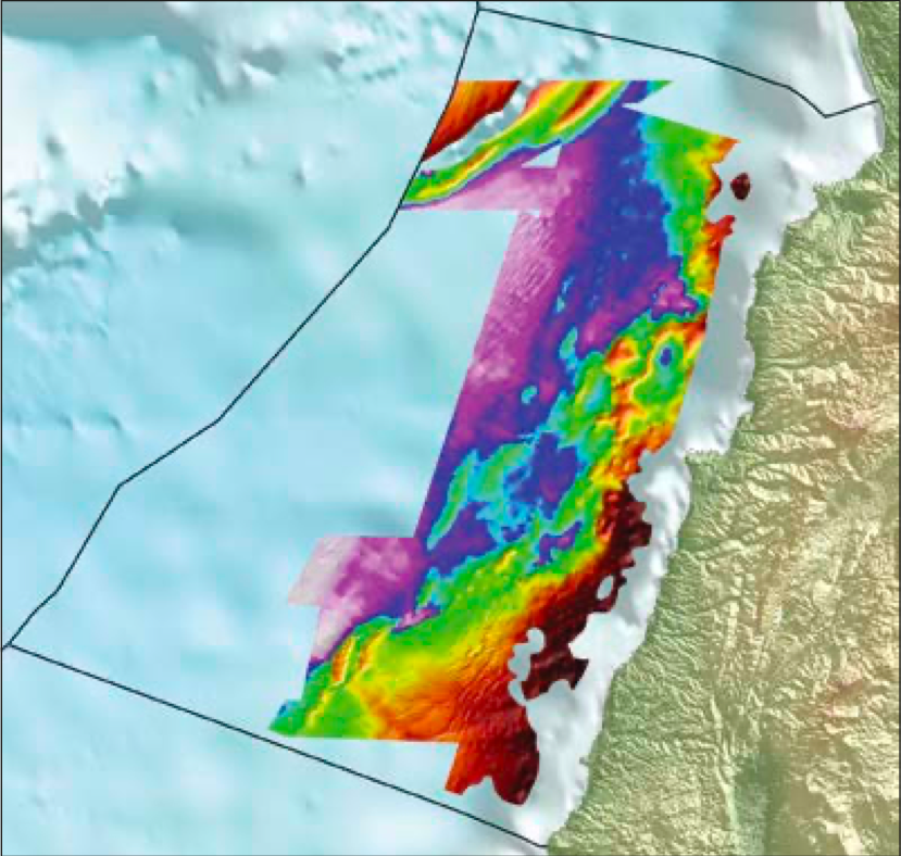
Lebanon PSDM MegaSurvey
Structural overview
Sediment transport patterns revealed
Acknowledgments
Related Articles


