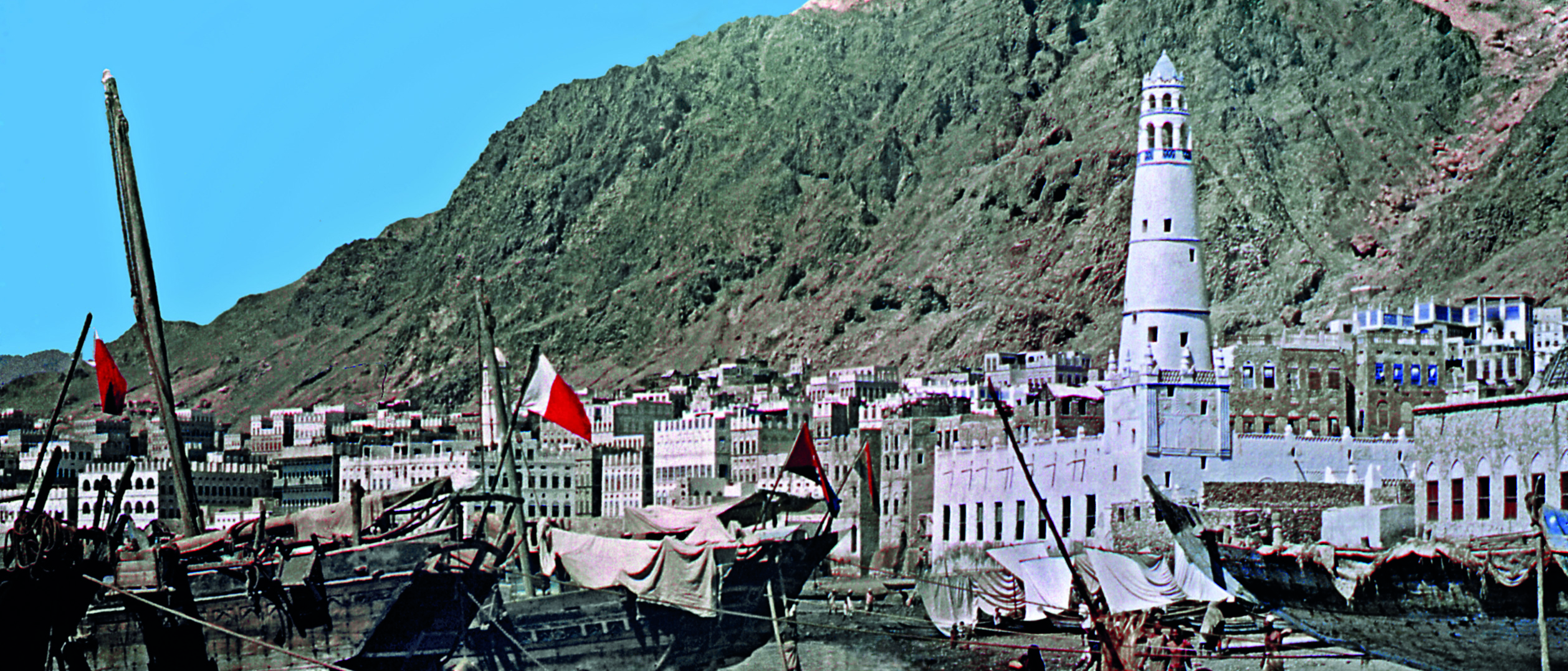
Al-Mukalla harbour in the 1950s. Source: Mike Morton
Oil exploration in Yemen
Yemen is a land of physical contrasts, bounded by mountains, desert and sea. It includes the Socotra archipelago and various islands in the Red Sea. At the heart of the south, like a deep gash across the land, is the Hadhramaut Valley. The geology of the region intrigued the early explorers, as it continues to do today. They had to overcome considerable political and physical difficulties as well as grapple with a complex geological puzzle that had its origins in the breakup of Gondwanaland.
“It is melancholy to find this interesting coast, which in former times was probably fertile and prosperous, now almost entirely desolate and the few inhabitants that remain nearly always at strife with their neighbors.” Thus wrote the commander of the survey ship Palinurus which, in 1846, carried Dr Henry Carter on the first geological survey of the land now known as Yemen. Carter, a medical officer in Bombay, was also a naturalist and geologist. Commissioned by the government of India to conduct the survey from the ship and on brief excursions, he published Memoir on the Geology of the South-East Coast of Arabia (1852), the first systematic account of geological observations of the region. Although a trickle of explorers followed in his wake, most notably an Austrian expedition in 1898–9, they did not advance far into the interior but produced some useful reports.
Today’s Yemen was then three separate political entities. To the north, the territory was under Ottoman occupation, and remained so until 1918. It was then ruled by Imams until 1962 when there was a revolution and a lengthy civil war. To the south, the town of Aden, a British colony since 1837, was primarily a strategic coaling station and later an oil refinery. In the south-eastern hinterland there were a number of small emirates that evolved into a British protectorate. The British withdrew in 1967 and the whole country – north and south – was united as the Yemen Republic in 1990.
Between the world wars
In 1921 rumors of oil seepages led the British government’s Petroleum Department to report: “Petroleum is also said to occur at many points in the interior of Yemen.” Although the main focus of the oil business was elsewhere in the Middle East at this time (see ‘The Emergence of the Arabian Oil Industry’, GeoExpro Vol. 5, No. 6), a few of its main players made cameo appearances. The ubiquitous Frank Holmes was interested in the oil prospects of the Farasan Islands, which belonged to the neighboring emirate of Asir, and in the Salif salt mines on the Red Sea coast. In 1929, the American millionaire Charles Crane sent mining engineer Karl Twitchell to Yemen to assist with water supply and agriculture, and investigate mineral prospects. Harry St. John Philby, an adviser to the Saudi king, visited Shabwa in 1936. Driving a station wagon and accompanied by a small detachment of Saudi guards, he swept out of the desert and caused much consternation among the British authorities. Although not a geologist, Philby kept a record of interesting geological features, such as oil seepages around Shabwa, and drew maps.
The Qu’aiti Sultan of Mukalla and Ash Shihr showed a keen interest in the mineral possibilities of his sultanate. This led to surveys around the port of Al-Mukalla which was, according to one British eccentric, the site of King Solomon’s Mines. In 1918, geologists Beeby Thomson and John Ball reported on coal and oil prospects. The following year, Dr Little of the Geological Survey of Egypt arrived to carry out a six-month mineral survey. His report was the first attempt to describe the stratigraphic and paleontological features of the area. Subsequently Shell, through their agent Anton Besse, discussed a concession for Ash Shihr, but their partners in the Turkish Petroleum Company (the forerunner of IPC – see next section) were against it.
Later explorers of the Hadhramaut in the 1930s were Von Wissman and Van der Meulan, and the great Arabian explorer Freya Stark, whose party included a female geologist, Miss Elinor Gardiner. These expeditions provided information and maps that would be useful to later surveys.
IPC and the search for oil
The oil strike in Bahrain in 1932, and the subsequent loss of the Saudi Arabian oil concession to Standard Oil of California, triggered the interest of the Iraq Petroleum Company (IPC) in the region. This company, a consortium of oil majors and Calouste Gulbenkian (see ‘Oil from Babylon to Iraq’, GeoExpro Vol. 6, No. 2), sought to pre-empt its rivals by obtaining oil concessions along the fringes of Arabia.
In 1936, Petroleum Concessions Limited (PCL), an associate company of IPC, obtained an exploration permit for the Aden Protectorates. In 1937, an IPC survey party working in neighboring Saudi Arabia obtained the Imam’s permission to survey to the north of Al-Hudaydah but the results were unpromising. In 1938, while Freya Stark was exploring the interior, Messrs Pike and Wofford were in the skies above, carrying out aerial surveys for PCL. They did some structural mapping of the Hadhramaut and around Al-Mukalla; but otherwise their work was restricted by the ‘local objections’ of tribesmen.
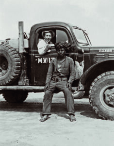
In 1946, IPC liaison officer Major Tony (Tadeus) Altounyan arrived with a box of Maria Theresa dollars (the currency of the time) and explored the Mahra country, the easternmost part of the Aden Protectorate, on camel. He returned in the autumn of 1947 with two geologists – the author’s father, Mike Morton, and René Wetzel. This party carried out a detailed surface examination of the Mahra country, retracing Altounyan’s footsteps of the previous year.
Rumors of oil shales and seepages persisted. In late 1949, the same geologists caused much excitement among the authorities in neighboring Yemen, who accused them of preparing an ‘invasion’. However, their reception in Beihan al-Qasab was friendly: the Emir of Beihan and his family, encouraged by stories of Saudi oil wealth, accompanied the geologists on all their excursions. Although the area generally lacked sufficient rock exposures to justify extensive geological work, the possibility of geophysical surveys around the northern border was left open.

In 1953, PCL established a geological base near the bedouin well at Thamud. For the next six years, Lebanese geologist Zaid Beydoun led a series of geological surveys which were supplemented by aerial and magnetic seismic surveys. Beydoun was a remarkable figure: as well as conducting a one-man survey of Socotra, he wrote extensively about the geology of south-western Arabia. In 1968, he co-authored a special report in which the geological nomenclature of the region was formalized. In 1994, the Geological Society of London awarded him the William Smith Medal for his ‘outstanding achievement in petroleum geology’. He noted that it was good to receive the award while he was still alive.
IPC’s search for oil ultimately proved fruitless. In 1959, the Company abandoned the Hadhramaut after failing to agree terms with the Sultans and, in the following year, withdrew from the Protectorate altogether. BP, which had separately investigated Kamaran Island in the Red Sea, also withdrew.
Success at Last
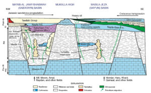
In the 1960s and 70s, as the overall geology of the Middle East was unraveled, the existence of some deep localized rift-related Jurassic basins was revealed. These were postulated to be associated with the breakup of the Gondwana supercontinent. The associated restricted basinal conditions had proved favorable for the development of good quality oil source rock. These in places had been buried sufficiently deeply to generate hydrocarbons, which in turn had subsequently migrated into accessible reservoir rocks. Younger Tertiary rifts in the Gulf of Suez also proved interesting.
After the departure of IPC, the first commercial drilling began in 1961 when the Mecom group drilled a number of dry holes on the Red Sea shore, followed by Shell between 1976 and 1980. In 1964, Pan American (Amoco) drilled a number of dry holes in the Aden Protectorate. Algerian and Russian groups also showed an interest, with the latter making some promising findings in the Shabwa area. In 1982, the Italian firm Agip made a marginal offshore discovery some 170 km east-north-east of Mukalla.
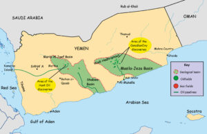
In the early 80s, at the instigation of Syrian geophysicist Moujib al-Malazi, Hunt Oil instituted a seismic program, predicated on aeromagnetic indications of a rift in the north-eastern part of North Yemen. Field indications of Jurassic instability, together with the presence of petroliferous shales, added significantly to the area’s attraction. Based on al-Malazi’s analysis of the seismic data, four prospects were drilled in the Ma’rib-Al Jawf Basin in 1984. Hydrocarbons were found in well-developed sands below a salt formation in three of those prospects, including the Alif No. 1 well, which tested at 7,800 bopd, the first discovery of oil on a commercial scale.

Since Beydoun’s outcrop studies had described Jurassic outcrops on the western flank of the Al-Mukalla high, there was a good possibility that the Jurassic rifting extended farther to the east. This prompted CanadianOxy and its original partner, Consolidated Contractors International, to acquire the 37,200 km2 Masila Block. In 1991, the existence of a second petroleum basin, the Masila-Jeza basin, was confirmed when CanadianOxy struck oil at Sunah No. 1. This was soon followed by more discoveries at Heijah, Camaal and Hemiar. By 2011, Yemen had twelve main producing blocks, operated by nine international oil companies.
Yemen today
Yemen had proven oil reserves of around three billion barrels as of January 1, 2012, and petroleum accounted for roughly 25% of GDP and 70% of government revenue. However, the country’s infrastructure, particularly its pipelines, has suffered from sabotage, leading to serious interruptions to the flow of oil. Piracy has curtailed offshore activity. If the difficult internal situation continues, the immediate future of oil exploration in the country looks uncertain.

Acknowledgement:
The author wishes to thank Nick Lee, Ian Maycock and Peter Morton for their assistance.


