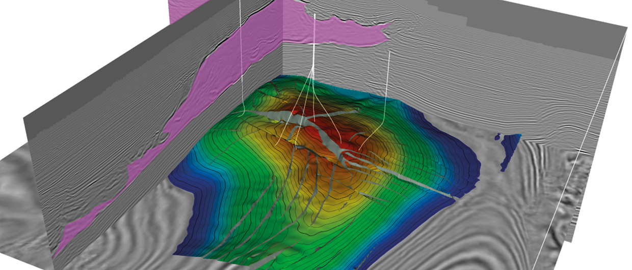
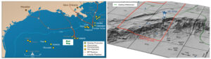
3D map view of the early Miocene reservoir horizon looking north-east, with selected wells shown in white. Red represents the high areas and blue represents the lows. Salt is pink. Source: Courtesy: Gulf Coast Section, Society of Sedimentary Geology Foundation (‘GCSSEPM’) and BP Exploration & Production Inc. (‘BP’).
Unleashing the true potential of the Mad Dog oil field
Technological imaging advances and a phased development in the 15 years since discovery have begun to unlock the full potential of the Mad Dog Field, increasing its known oil-in-place nearly tenfold to up to four billion barrels of oil equivalent.
Mapping on a 1996 vintage 3D seismic survey over the southern Green Canyon area of the Central Gulf of Mexico revealed a broad, simple, anticlinal high. Reflectivity was very poor over the structure’s crest, which was located beneath the main salt body. Imaging showed good reflectors outboard of the salt to the south and fair reflectors beneath the thin salt on the north side of the structure. In 1998, the first well on this structure was drilled seaward of the Sigsbee Escarpment through the good reflectors and finally into the crest, encountering 66m of hydrocarbon-bearing Miocene reservoirs. The Mad Dog Field had been discovered.
Early appraisal wells would soon confirm an economically developable resource of about 450 MMbo in-place but also illustrated to the subsurface appraisal team the need for better seismic imaging. These wells encountered fault blocks not seen on seismic data. Some of these fault blocks were not hydrocarbon charged, adding risk to the development over the crest. Also, drilling problems arose from the significant amounts of mobile tar deposits encountered in the overburden section. The early drilling results led BP and its co-owners, BHP Billiton Petroleum (‘BHP’) and Union Oil Company of California (‘Unocal’, owned by Chevron), to take a very calculated and incremental approach in developing this field. The results have been outstanding, turning a relatively small, deepwater field into a giant that is expected to produce significant oil for the next 40 years.
From simple to complex
When appraisal wells drilled between 1999 and 2001 showed the presence of enough hydrocarbons to develop, planning for production began. In February 2002 a truss spar equipped with an integrated drilling rig that included 16 slots was approved by the project co-owners. The overall development would cost around $1.5 billion. The truss spar would be permanently moored in 1,311m of water and capable of processing 80,000 bopd and 60 MMcfgpd. The first production commenced on January 13, 2005.
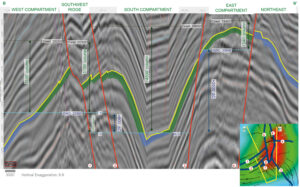
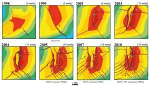
Immediately after the first production, south-west ridge appraisal wells drilled by Unocal extended the oil column 245m deeper on the west side of the structure. They drilled an updip sidetrack to the well and found a wet compartment. Drilling problems arose on additional deep tests when several six meter-thick, mobile tar intervals flowed into the wellbore and proved impassable. The subsurface picture was now becoming more complex. A wide-azimuth towed streamer (WATS) seismic survey was consequently commissioned (see Improved Seismic Imaging section on the image above).
“We interpreted that the A5 producer was connected to a large volume of fluid from pressure transient analysis but were unable to place a follow-up well because of poor data quality,” recalls Dr. Christopher Walker, structural geologist for Mad Dog Phase 2 with BP. “The map generated from the WATS data revealed a large undrilled compartment. We planned the #11 well to test the projected oil/water contact (OWC) in this block, but at our target depth the sands were still full of oil. The team was able to chase the OWC down dip, using real-time biostratigraphy, real-time azimuthal density and gamma ray information and the current truss spar.”
The successful west appraisal wells indicated to the team that before updating the strategy to optimize recovery, the other untested flanks of the structure needed to be fully appraised. Thus, the Mad Dog South well was planned. A previous well in that area had hit water-bearing sand updip of the planned south appraisal target, reducing the probability of finding hydrocarbons on the south flank of the structure. “This is where the 2009 reprocessing of the 2005 WATS data proved valuable,” explains Dr. Walker. “Vertical Transverse Isotropy (VTI) depth migration was applied to the data to reveal an intricate web of faults on the crest of the south flank. This allowed us to interpret the wet penetration as a sealed fault block, and opened up the possibility of an accumulation down dip. The #5 well drilled by BHP in May 2009 greatly exceeded pre-drill expectations by discovering 85m of net MD pay in the early Miocene sands still full to base. A side-tracked well extended the lowest known oil another 40m deeper than on the west flank, which led to another large increase in the oil-in-place resources.”
The most recent field extension drilling took place in 2011 when BHP drilled the Mad Dog North appraisal well. This well was again successful, finding 50.6m net pay. They were also able to collect conventional core for the entire reservoir section for the first time in the 13-year history of investigation of the field. The core information would help refine the design parameters for the next phase of field development.
Improved seismic imaging of the Mad Dog Field, Gulf of Mexico
“The first appraisal wells clearly indicated we needed better seismic imaging to safely and economically develop this field,” says Dr. Walker. “The water depths over the field vary from 1,200m to 2,100m across the 610m high Sigsbee Escarpment and the reservoir is at depths greater than 5,800m beneath a layer of allochthonous salt. This salt layer varies greatly in thickness, with steeply dipping edges, overhangs and a rugose base and top, creating challenges for seismic imaging of the reservoir. Such irregularities create illumination gaps where reflected seismic energy cannot be adequately acquired using narrow azimuth 3D seismic methods.
“The progressive development of the field can be intimately tied to advances made in seismic data acquisition and processing technology,” Dr. Walker explains. “The first major imaging improvement was achieved when we were able to merge the original data with new narrow azimuth towed streamer (NATS) data acquired in a different orientation in 2000, creating a multi-azimuth image. New subsurface density information from the wells allowed us to build a better velocity model which further improved the image quality. However, between 2001 and 2005, the appraisal and development wells that were drilled for the first production facility continued to encounter subsurface surprises, including the largest fault in the field, with over 305m of missing section.
These surprises, along with the potential for additional hydrocarbons, led BP to commission the industry’s first large-scale, wide-azimuth towed streamer (WATS) program across the field in 2004. “The new wide-azimuth data would prove to be a real game changer for imaging the field,” says Dr. Walker. “This method allowed the collection of longer offset data compared to conventional NATS acquisition. The method increased the illumination of the reservoir by recording data from a range of azimuths that have taken complex paths through the overburden. Much better reflectivity of the structure’s crest and the mapping of additional faults revealed for the first time the potential size of the trap and allowed more challenging wells to be planned. This data was reprocessed in 2009 resulting in additional clarity over the structure.”
The development
With new volumes found shortly after the first oil was produced and the additional success of subsequent appraisal wells, Mad Dog’s in-place resource estimates exceeded the capabilities of the original truss spar. For the operators to safely and efficiently produce these resources, a Phase 2 project was initiated. An all-subsea development was recommended which was to be tied back to a second spar host facility with a capacity of 130,000 bopd. A water-flood project was also planned to enhance flank oil recovery. The second truss spar called ‘Big Dog Spar’ is expected to be sanctioned by the co-owners in 2013.
Dr. Walker explains that, “By starting small and developing known hydrocarbons, investing in technology to improve the seismic imaging of the field and a continuing appraisal drilling program, the team of geoscientists and engineers assigned to the field was able to evaluate resources while simultaneously unlocking their value. Our early oil-in-place estimates were 450 million barrels. Integrating production data with the improved seismic imaging and appraisal wells has allowed the second phase of evaluation to proceed with greatly reduced subsurface uncertainty. The estimates of the field have grown substantially since the first single spar development in 2005 because we were able to accurately locate additional appraisal wells that greatly extended known OWC in different compartments of the structure. The oil in-place is now up to 4 Bboe. We are currently planning the second phase of development that will involve the design and construction of a new production facility, which will make the Mad Dog Field a major Gulf producer for decades to come.”