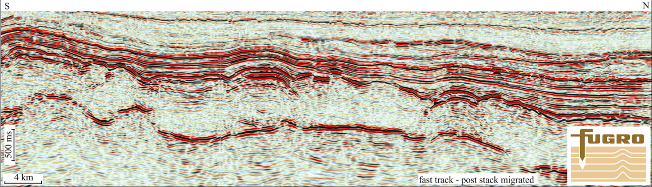
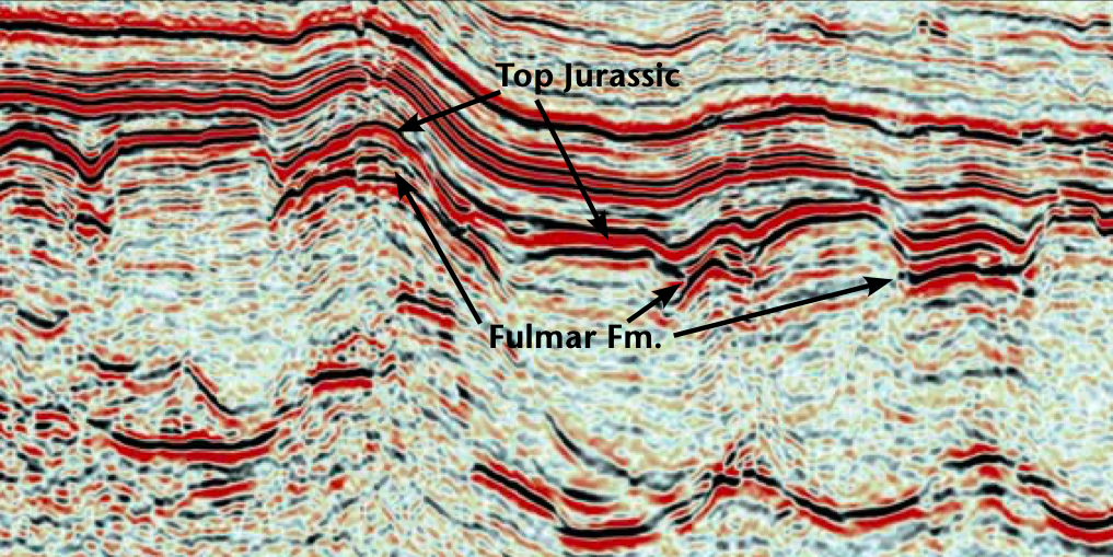
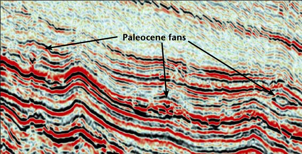
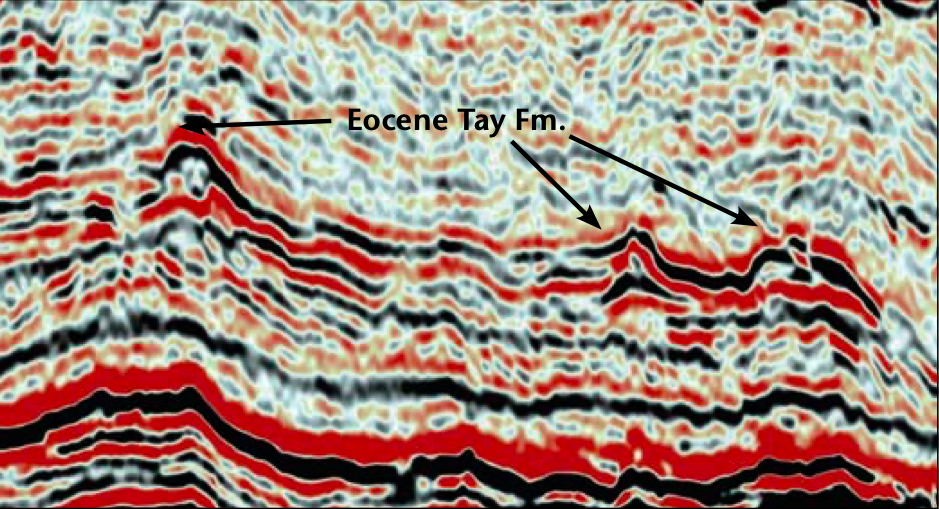
New Multiclient UK Q20/21 Survey Provides Insight into Proven and Emerging Plays. The multiclient 3D UK Q20/21 fast track dataset from the West Central Shelf (previously Blakeney) considerably improves the understanding of distribution of hydrocarbon reservoirs and migration pathways. The main targets for the 3D dataset are the Upper Jurassic Fulmar Formation, Paleocene and Eocene channel-fan complexes. The 3D data was acquired using a cable length of 6,000m, enabling very good imaging of the Mesozoic and Cenozoic sedimentary successions. As the recent 27th UK licensing round demonstrates, the West Central Shelf remains one of the most interesting hydrocarbon provinces in Europe. The high resolution multiclient fast track UK Q20/21 3D, together with recent discoveries, opens up new and promising hydrocarbon exploration and revisits proven plays. The new high resolution long-offset 3D seismic data enhance the understanding of reservoir distribution and hydrocarbon migration. The West Central Shelf represents the western platform relative to the Central Graben. The area is filled with Mesozoic and Cenozoic sedimentary successions, which were deposited prior to and after the Late Jurassic rifting event. Only minor extension took place in the West Central Shelf during the Late Jurassic rifting event, excluding the well known rift play as characteristic for most of the North Sea petroleum province. Also, large parts of the Triassic and Jurassic successions are missing due to Late Jurassic erosion. The Zechstein evaporites had a significant control on sedimentation in both middle to late Triassic and in Late Jurassic times. Eastwards and south-eastward progradation from East Shetland Platform, and deposition of significant amounts of sand took place in the Paleocene and Eocene times. This has given rise to some of the greatest oil fields (e.g. Forties field) in the nearby area, with inversion along salt diapirs in Late Paleogene times creating structural traps. The new multiclient 3D dataset is situated within UK quadrants 20 and 21. Several of the largest UK oil and gas fields are producing in the West Central Shelf area, including Kittiwake, Durward, Dauntless, Forties, Nelson and Goosander. Although the West Central Shelf is considered a mature hydrocarbon province, recent discoveries in the Eocene succession, such as the Blakeney field, have proven the potential of discovering more high quality reservoirs in the area. The main targets within the 3D survey area are the Upper Jurassic Fulmar Formation, Paleocene marine and Eocene channel-fan complexes. The Upper Jurassic and Eocene plays are already proven commercial driven plays, but less interest has been shown in the emerging Paleocene play. The new acquired dataset reveals three main reservoir levels in the UK Q20/21 survey area, all of which have the potential for trapping hydrocarbons in structural and stratigraphic traps. These are the Late Jurassic, Paleocene and Eocene sedimentary successions. In addition, Early Cretaceous and Triassic may be producible across large parts of the survey area. The source rock is believed to be the Upper Jurassic Kimmeridge Clay Formation, with migration from the Central Graben. Long migration pathways have been demonstrated to work along the Dauntless-Kittiwake-Mallard trend in the northern part of quadrant 21 and on the eastern side of the Central Graben (e.g. Siri, a Paleocene discovery). Producing fields just east of the survey area show that the Kimmeridge Clay is mature and may involve potentially shorter migration pathways. The new high resolution long-offset UK Q20/21 seismic dataset enhances the understanding of reservoir distribution and hydrocarbon migration in the area, allowing evaluation of both proven and emerging plays. The Upper Jurassic has been explored throughout the last decades on the Norwegian Continental Shelf. By utilizing datasets acquired by FMCS, a Fulmar analog has been identified. This play remains to be tested on the Norwegian Continental Shelf and requires new high resolution 3D data to increase the understanding of the reservoir distribution and hydrocarbon migration. The geological model for the Upper Jurassic interval suggests that Fulmar sand distribution was largely controlled by pre- existing topography (Stewart et al., 1999). Salt dissolution took place within salt structures in Late Jurassic time, creating accommodation space, whereas Triassic mini-basins acted as barriers. Here, shallow marine/shoreface sedimentation prevailed throughout Late Jurassic, with irregular deposition of the Fulmar Formation. The Fulmar sands represent one of the most important proven and emerging hydrocarbon reservoirs in the Central North Sea, UK, including discoveries in several nearby oil fields (e.g. Kittiwake, Durward, Dauntless). Predicting and interpreting the Fulmar sand distribution has often been problematic throughout the basin, especially so on the West Central Shelf (Stewart et al., 1999). To date, the wells that have drilled the Fulmar Formation in the survey area have targeted four way dip closures above the salt structures. However, the new dataset shows that significant parts of the Fulmar Formation are also likely to be present in stratigraphic traps above salt structures which have not been remobilized. A thorough interpretation of the stratigraphic traps requires high resolution 3D seismic. A complete interpretation and mapping of the Late Jurassic Fulmar Formation and its irregular sand distribution is possible, revealing the potential for several more hydrocarbon prospects by utilizing the new dataset. The Paleocene play on the West Central Shelf includes deep marine fan complexes which were sourced from the East Shetland Platform area in the north. Traditionally, the Blakeney area has been considered to be too distal relative to the East Shetland Platform for deposition of sands with good reservoir quality. However, utilizing the new high resolution UK Q20/21 3D dataset, deep marine channel-fan complexes are identified within the survey area. Clinoform geometries are observed in the eastern part of the 3D area, invoking the potential for a more proximal source area to the west. Differential compaction and Paleogene salt diapirism develop robust closures reflecting potential for both structural and stratigraphic traps. In the Eocene, major progradation took place in the southern parts of the survey area, with sediment dispersal eastwards and north-eastwards. A complete shallow marine – channel – deep marine fan system is mapped out on the 3D survey with large potential for trapping hydrocarbons in different sedimentary facies. Differences in amplitude strength reveal numerous deep marine channel-fan complexes within the survey area. Less than ten wells have been drilled over the northern part of the area with the Eocene succession as the target, constraining the depositional model. Most of these wells were dry, allocated to the lack of understanding of hydrocarbon migration pattern. Interpretation of the new 3D dataset indicates westwards migration, giving rise to the possibility of more successful drilling in the future. This project was carried out in conjunction with Dolphin Geophysical. Stewart, S. A., Fraser, S. I., Cartwright, J. A., Clark, J. A. & Johnson, H. D. 1999. Controls on Upper Jurassic sediment distribution in the *Anthony Pedley FMCS UK:.Email: a.pedley@fugromcs.co.uk, Tel: +44 (0)1491 820602 / Mob: +44 (0) 797 019 3993. Web: www.fugromulticlient.com *Sverre Berstad FMCS Norway: Email: s.berstad@fugro.no, Tel: :+47 2213 4611 / Mob: +47 9961 761. Web: www.fugromulticlient.com
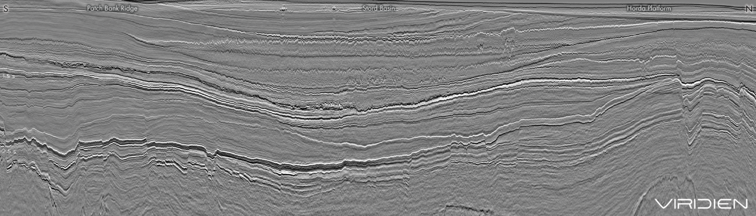
Western margin of UK Central Graben
Geological overview
Hydrocarbon potential
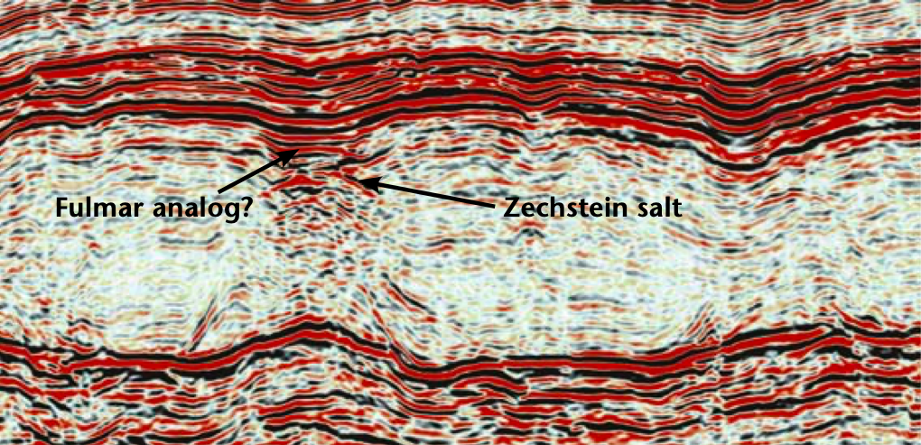
Analog Jurassic play on the Norwegian Continental Shelf
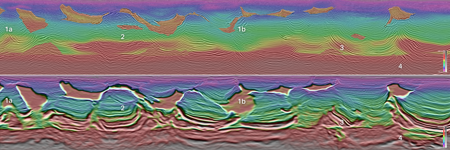
Jurassic play: Fulmar Formation – salt dissolution creating accommodation space
Paleocene play
Eocene Play: Tay Formation
References
Durward-Dauntless area, UK Blocks 21/11, 21/16. In: Fleet, A. J. & Boldy, S. A. R. (eds) Petroleum Geology of Northwest Europe: Proceedings of the 5th Conference, 879-896. © Petroleum Geology ‘86 Ltd. Published by the Geological Society, London.Related Articles