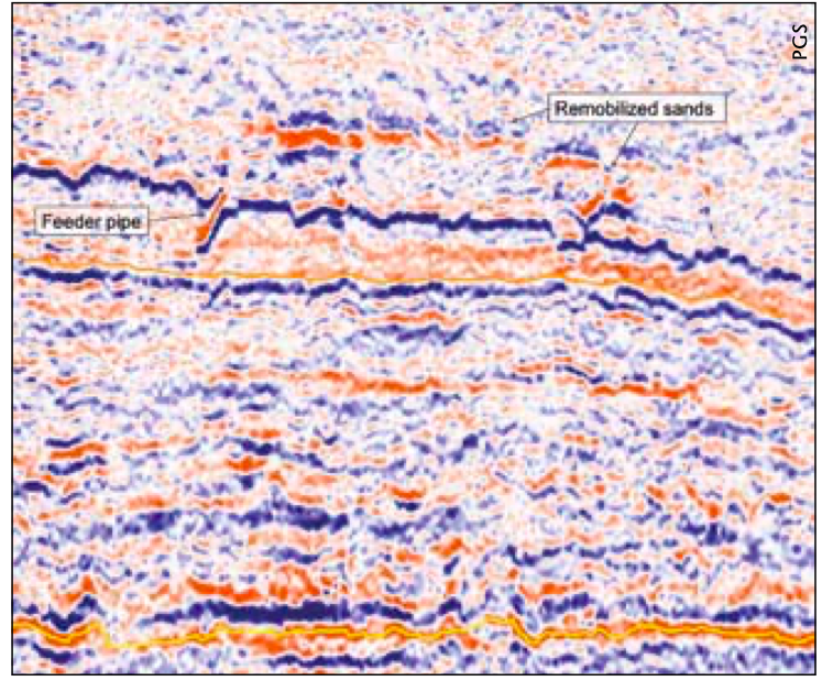
The North Sea is a mature hydrocarbon province in which there has been extensive exploration but where continued discoveries have ensured a sustained interest. The availability of modern, high quality seismic data has highlighted the continuing prospectivity of the Viking Graben such that, even after several decades of extensive exploration, development and production, it remains an important hydrocarbon exploration province. The North Viking Graben GeoStreamer® MC3D seismic survey was acquired between 2009 and 2011 (in partnership with TGS) using the innovative dual sensor GeoStreamer technology. The result is a substantially improved dataset covering a significant area of the Nrth Sea, allowing the realisation of new potential in this mature region. The North Viking Graben is an established hydrocarbon province that after more than 30 years of exploration activity is widely regarded as mature. However, new, high quality data reveals additional potential in the area. The North Viking Graben is an established hydrocarbon province that after more than 30 years of exploration activity is widely regarded as mature. However, new, high quality data reveals additional potential in the area. The NVG GeoStreamer® MC3D survey (acquired in partnership with TGS) was obtained over three seasons and provides high quality regional coverage along the North Viking Graben. PGS now has continuous broadband seismic data covering 5,800 km2 in the North Viking Graben and this merges seamlessly into the SVG GeoStreamer MC3D survey in the South Viking Graben. The dual sensor technology enables the upand downgoing wavefields to be separated and this provides greater bandwidth and finer resolution of the seismic data. PGS have championed the importance of regional datasets for many years and have been developing and extending the global MegaSurveys since the 1990s. Most recently there has been a focus upon ensuring that the regional data incorporates not only the widest possible geographic area but is also of the highest quality. In order to achieve this, PGS have embarked on a programme of new broad band seismic acquisition to produce high quality regional datasets. This enables a regional perspective and understanding to be obtained and also reveals the full exploration potential in the greatest detail. In mature areas such as the North Viking Graben it is very important to continue to strive to improve the data and enhance image quality in order to expand upon existing plays which are far from exhausted and also to open new opportunities. The North Viking Graben region is an established hydrocarbon province in the North Sea straddling the UK/ Norway boundary and it contains important plays in both the Jurassic and Tertiary (particularly the Eocene and Paleocene) stratigraphic levels within the graben area. There are also underexplored plays in Lower Cretaceous sands and additionally the Paleocene/Eocene injectite play. Exploration success began in the area in the 1960s with the discovery of the Balder field on the Utsira High (1966). Hydrocarbons were found in the Paleocene clastic sediments of the Balder Formation and successes within the Tertiary continued into the early 1970s with the discovery of the Eocene sands of the Frigg Field. However, these Tertiary plays can be complex in their distribution and development and difficult to model and map – the new highquality data provides the opportunity of reevaluating some of these difficult plays and prospects and offers the possibility of establishing new potential. Where the fan systems are compartmentalised (such as in Frigg Field) with a variety of barriers and baffles, the production of the hydrocarbons is not simple. The high resolution retained in the GeoStreamer data could assist by providing more insight into the overall connectivity. Remobilised Tertiary sandstone reservoirs have become an important play to consider in both the UK and Norwegian sectors. They remain an underexplored and difficult play and the injected sand bodies generally have highly complex geometries and certain features that are infrequently successfully resolved on conventional seismic data. However, there are several wellknown examples of injectite reservoirs including Gryphon and Leadon (UK) and Grane and Jotun (Norway). In these fields the injectites have excellent reservoir qualities, with high porosity and permeability values, and there is therefore every reason to believe that similar sands will in most cases form good reservoirs. The features which define the sand injectites, and which can be recognised within seismic, include mounds, detached reflectors which are often bright, and lateral wings and ridges which may crosscut original stratigraphic relationships. The GeoStreamer data not only resolves these features, enabling a good definition of the sand geometry, but also the feeder dykes from the sand horizons below. This allows a clear assessment of the potential for charge from below and also the possibility of any top seal breach of deeper reservoirs. The GeoStreamer dataset is therefore very significant for refining any geological models and for reservoir evaluation. Illuminating New Potential Elsewhere, the enhanced resolution of the new NVG survey can illuminate new potential. The figure on the right shows a clear flat spot, that we are confident is a direct hydrocarbon indicator. The trapping structure is a 3way dip closure against a low offset fault where the closure can be clearly mapped. Surrounding this feature are proven prospects and fields and we are confident that the hydrocarbon system in place can charge this structure. As the image shows, the flat spot is clearly visible on the NVG GeoStreamer survey, but is not visible in the legacy data we have over the same area. The Lower Cretaceous has proved a significant play in the UK sector where the East Shetland Platform acted as a major sediment source. Equivalent age prospects on the Norwegian side of the graben are more difficult to locate and are arguably underexplored. However, similar sands have been found in the Lower Cretaceous on the Norwegian side of the North Sea in the recent Apollo discovery. This discovery indicates that the Utsira High area possibly acted as a local sediment source during Valanginian time and it is hoped that modern seismic may lead to discovery of more Lower Cretaceous reservoir potential in the area. The Jurassic plays are important along both the Norwegian and UK continental shelves and the North Viking Graben is a classic sedimentary basin in which the extensional tectonics are fundamental to the distribution of oil and gas. With the higher quality broadband seismic it is possible to more clearly image the main structures at depth which control the distribution of hydrocarbons in the area – in particular in the Jurassic fields. The GeoStreamer line illustrated on the foldout shows the improved clarity and imaging of Brent fault blocks with, in particular, an improved definition (over legacy data) of the top Brent reflector which sheds new light on currently undrilled fault blocks. The area covered by this NVG survey represents a mature zone where the easy to find targets have already been discovered and exploited. The tool for unlocking further play identification and prospect generation is the newly acquired high quality 3D data. This allows us to unravel and interpret the complex geological features: stratigraphy, geometry, deep and/or fractured targets etc. and enables us to unveil new potential. The significance of this technology was proven with the discovery of Johan Sverdrup from interpretation of GeoStreamer data, and in this NVG dataset it is now possible to see improved resolution and penetration along with previously unidentified DHIs.
Broadband 3D: building blocks for exploration in a mature setting
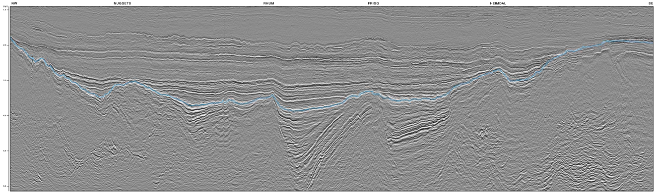
The seismic section shown traverses the North Viking Graben from the north-west to the south-east and transects several of the major fields and discoveries including Rhum, Frigg and Heimdal.
Improved resolution and penetration with Broadband 3D
High resolution provides insights
Tool to unlock new plays
Related Articles


