RTM depth processing of the pre- and post-evaporite sequences displays clearly the following mega sequence packages: The deepwater region of Brazil’s pre-salt province covers an area of over 122,000 km2. It has attracted growing interest for oil and gas exploration with many discoveries, some of them giants, being made in the Santos, Campos and Espirito Santos basins. Still largely underexplored, the Santos Basin has high potential for hydrocarbon exploration, due to its analogy with the neighbouring Campos Basin to the north, based on its similarities within petroleum systems, tectonics and stratigraphic evolution. New 3D seismic data acquired by CGGVeritas is key in revealing the pre-salt potential in the Santos Basin. The 23,000 km2 Cluster Survey covers the major Lula, Carioca and Jupiter discoveries, whilst the 16,000 km2 Cluster Extension Survey covers an area with predominantly unlicensed acreage, where, to date, only three wells have been drilled, all of which have encountered oil shows. The South Atlantic salt province developed diachronously in the Aptian and consists of a number of basins, separated by deep rifts, and by basement and volcanic eastwardyounging highs (Davison, 2007). Initial rifting of the South Atlantic began with the break-up of Western Gondwana during the Late Jurassic/ Early Cretaceous and advanced northwards. The syn-rift phase saw the formation of a number of synthetic and antithetic faults, creating several half-graben which were later infilled with volcaniclastics and fluvio-deltaic sediments. Early syn-rift sediments in the Santos Basin consist of lacustrine shales and sandstones with coarse-grained alluvial fans deposited along the faulted basin borders and rift lakes infilled with fluvio-deltaic sandstones. A later rift cycle shows a shift to restricted marine conditions with the de position of organic shales, coarse-grained siliciclastics and coquina shell limestones. During a period of thermal subsidence, potential reservoirs of microbial and stromatolitic carbonates were deposited in a restricted marine environment. Continuing this period of transition from rift to drift phase the deposition of evaporites occurred in the Santos and Campos basins. The succession starts with Early Aptian siliciclastics to Late Aptian/Early Albian halites and anhydrites (Cainelli et al., 1999). Restricted marine conditions commenced from Albian to Turonian, with the deposition of carbonates followed by turbiditic siliciclastics depicting a hemipelagic environment from Late Cretaceous to Quaternary. The evaporite package is a reflective sequence of deformed halite, interbedded autochthonous anhydrite and clastic sediments of Aptian age. The top evaporite pick is a strong high-amplitude unconformity known as the ‘Enigmatic Reflector’ (Davison, 2007) and the majority of the mobile halite appears to be capped by this horizon. The halite sequence is found towards the base of the evaporite package and appears to pierce through into the layered evaporites and clastics. Regional tectonics and sediment loading by the layered anhydrites is the cause of displacement of the underlying halite, which creates a series of salt walls, folds and diapirs. In areas where halite has withdrawn, the layered anhydrites appear conformable and undeformed as a package, particularly over the Santos Outer High (Gomes et al., 2002). Where the halite forms diapiric structures and salt walls, the anhydrite displays chaotic reflectivity and is highly distorted. Periodic phases of salt movement can be seen through a number of unconformities within the anhydrites and also seen reflected by the present day seafloor. The Santos Outer High is a prominent feature throughout the survey. It has a north-east to south-west orientation which is believed to represent the underlying, pre-existing fault trend. The high is comprised of syn-rift siliciclastic and volcanic deposits overlain by postrift, sag phase carbonate facies. Its crest exhibits irregular topography due to faulting and erosion. The syn-rift is underlain by volcanic rocks, which appear as high amplitude, parallel to sub-parallel reflectors on seismic. The rift series displays a volcaniclastic base, followed by a sand-dominated interval overlain by a shale-rich sequence and a carbonate-dominated upper section. This package is clearly imaged and faults can be picked into the deepest parts of the section (up to 10 km subsea). The syn-rift sediments are highly faulted and characterised by a series of graben and half graben. Faults have a dip of 24°–39° and sediment displays clear growth into the hanging walls, in places reaching over three kilometres in thickness. The seismic appears dimmer at depths where the stratigraphy is sand-dominated and heavily affected by faulting, in contrast to areas in which the sediment type alternates between sand, carbonate and clay, where the seismic is characterised by high-amplitude and continuous reflectors. At the base of the sag phase is an unconformity which represents a major change in depositional environment. The sediment package is commonly between 400 and 700m in thickness, with highamplitude, parallel reflectors. This sequence contains the majority of the discovered pre-salt carbonate reservoirs along with inter-bedded potential source rocks. Syn-rift faults generally terminate at the base of the sag sequence, and where faults pass through to the base evaporite layer no thickening into the hanging wall is seen. Basement highs are a key control in the location of potential pre-salt reservoirs. Pre-dating the continental break-up of the South Atlantic, the Santos Outer High, trending across both 3D surveys, was located approximately 200 km from the African and Brazilian continental margins (Gomes et al., 2009). This distal setting and the prominent palaeotopographic relief of the outer high resulted in an ocean-ward clastically-starved shallow water environment, which had a major influence on the distribution of potential pre-salt reservoirs. Prior to the deposition of evaporites within the basin, the likely environment for pre-salt reservoirs is thought to be a transition from a lacustrine to a restricted marine, carbonate platform. Carbonate accumulations are best developed on faulted basement blocks. Increased subsidence during the sag phase aided the rapid growth of the carbonates and later uplift and exposure may have helped to enhance reservoir quality through the formation of secondary porosity (Gomes et al., 2009). Characteristics of these structures The quality of the CGGVeritas seismic data enables a more detailed interpretation of the sub-salt facies, and a greater understanding of basin evolution. There is considerable potential for further discoveries in the Santos Basin, as advanced seismic data, such as this new 3D PSDM multi-client survey, reveals the intricacies of the structure and stratigraphy of this highly prospective basin and furthers the success of pre-salt drilling. Cainelli, C. and Mohriak, W. U., 1999, Some remarks on the evolution of sedimentary basins along the eastern Brazilian continental margin. Episodes, v. 22, no. 3, p. 206-216. Davison, I., 2007, Geology and tectonics of South Atlantic Brazilian salt basins. From: Reis, A. C., Butler, R. W .H. & Graham, R. H. (eds). Deformation of the Continental Crust: The Legacy of Mike Coward. Geological Society, London, Special Publications, v. 272, p. 345-359. Gomes, P. O., Parry, J. and Martins, W., 2002, The Outer High of the Santos Basin, Southern Sao Paulo Plateau, Brazil: Tectonic Setting, Relation to Volcanic Events and some Comments on Hydrocarbon Potential. AAPG Herdberg Conference, Stavanger, Norway.
Santos Basin: Complex salt structures and pre-salt potential revealed by new CGGVeritas 3D data
– A deeper sequence package, encountered in wells, includes interbedded sediments of volcanic and clastic origin.
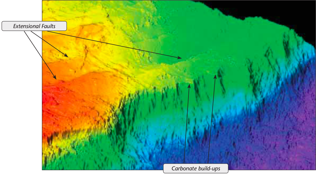
– A syn-rift package, which can be differentiated into a lower and upper succession, each clearly displaying growth and thickening into extensional faults.
– A post-rift sag package which consists of potential pre-evaporite reservoirs, with main reservoir targets of lacustrine coquinas and restricted marine microbial stromatolites.
– These are overlain by a thick mobil and layered evaporite sequence. The influence of evaporites can be seen in the shallow section and acts as a detachment for localised compressional thrusts and extensional historic fault features.
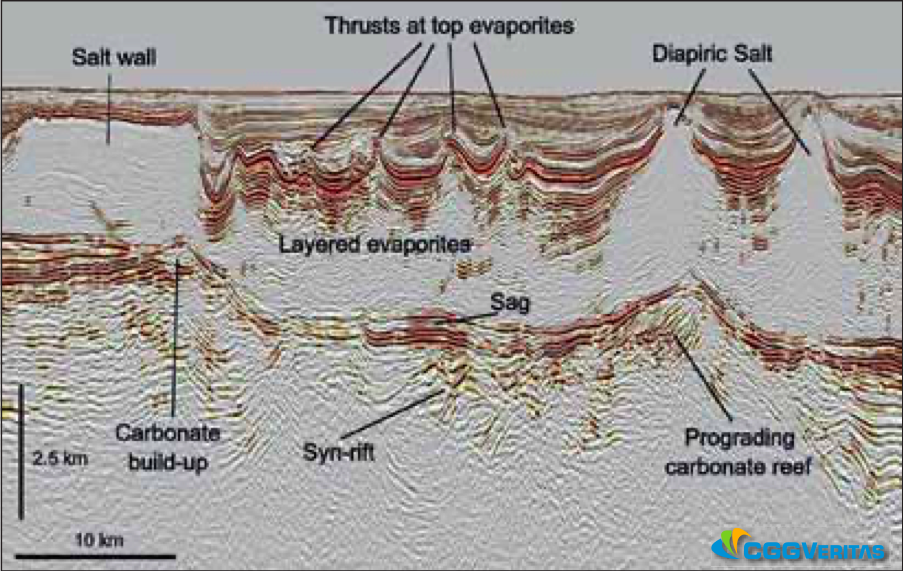
Source: CGG Veritas.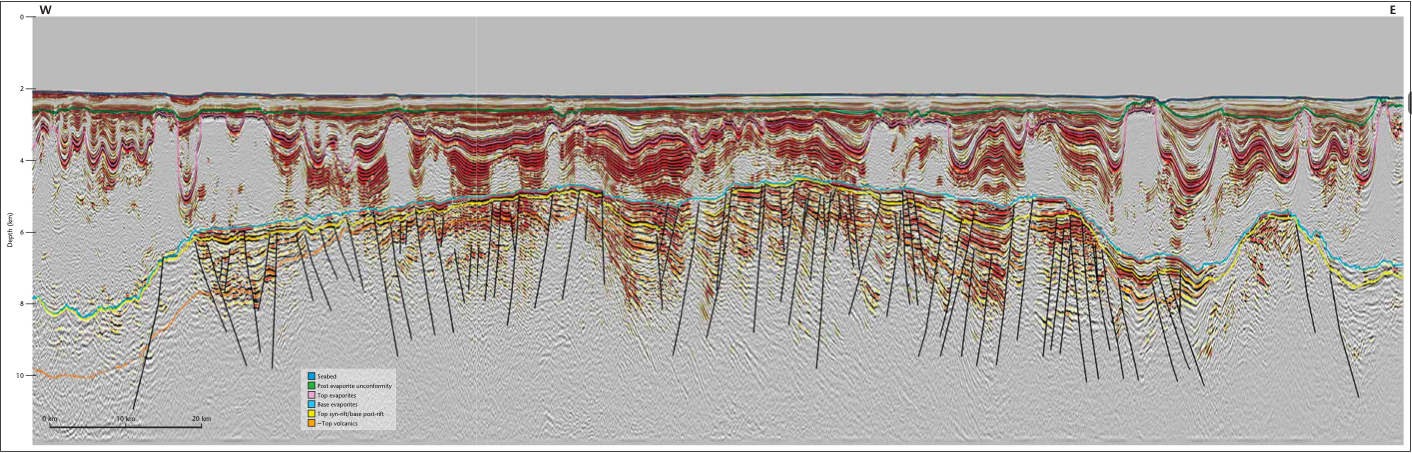 The CGGVeritas Santos Basin multi-client dataset now extends over 39,000 km2 within the Santos Basin. This west–east trending seismic line, taken from the 3D Cluster Extension survey, is an example of the high-quality imaging that has been achieved beneath the salt in this structurally complex basin. The line extends over the Santos Outer High, which is an extensively faulted ridge crossing the basin from north-east to south-west. Source: CGGVeritas.
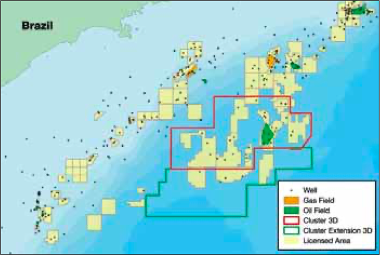
New Geological Insights Into the Santos Basin
New PSDM 3D seismic reflection data over the highly prolific Santos Basin provides comprehensive insight into, and enables a better understanding of, the evaporite architecture and potential pre-salt hydrocarbon reservoirs.
Regional geology
Salt architecture
Sub-salt
Reservoir distribution
display a clear base structure and pointed crest geometries, with internal layering indicating build-up and progradation. Post-rift stromatolites and microbial carbonates are the producing reservoir in the Lula Field and similar features can be seen across the entire basin and within the new 3D seismic coverage.References
Related Articles