New Digital Africa Maps
New digital maps, based on ones originally produced by Africa specialist Ed Purdy, should shed new light on the exploration of the continent.
Ed Purdy was an explorationist, academician and teacher. To many he is best remembered as a pioneer in the field of carbonate sedimentology but Ed also made significant contributions to the understanding of African geology. In 1989, Ed authored maps showing the Exploration Fabric of Africa, and African Basins. Using data from a variety of sources he compiled regional geology, tectonic framework and a range of exploration-oriented information. The maps were published at scales of 1:5,000,000 and 1:10,000,000 and were accompanied by a set of explanatory notes. They were well received and over 1,000 copies were produced and distributed.
Sadly, Ed died in October 2009, and as a tribute to the contribution he made to geology, friends and former colleagues decided that his Africa maps should be updated to reflect significant recent developments in oil and gas exploration in Africa, including deep water West Africa, Nile Delta, the Transform Margin and the Ugandan Rift Valley.
The Exploration Fabric of Africa Project (EFA) has been sponsored by 23 companies with interest in Africa and their contributions are being used to prepare an exploration GIS using ESRI ArcGIS software. Hardcopy maps and other digital output will be published by the American Association of Petroleum Geologists. Currently, two beta versions have been released and a final version will be available in 2012.
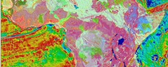
Wide Range of Data
Digital geological datasets included in the project are a version of Ed Purdy’s surface geology, the USGS 1997 data and a digital geological dataset derived in part from UNESCO maps of Africa. Outcrop geology is constructed as a series of polygons each of which is attributed with chronostratigraphic and lithostratigraphic information.
Public domain gravity and magnetic data have been reprocessed and new grids showing isostatic gravity, Bouguer gravity and total magnetic intensity have been produced Other grids have been prepared to show bathymetry, based on Gebco data, and relief, from SRTM 90m data.
Depth-to-basement and total sediment thickness maps have been prepared from inversions of the gravity and magnetic data, calibrated to a variety of G&G data (wells, seismic etc).
Over 1,200 fields and significant discoveries are included in the GIS, together with information on hydrocarbon types, seeps and play fairways.
The AAPG group of layers all contain hyperlinks which allow searching of AAPG Datapages publications. The AAPG Seismic Atlas layer contains links to over 600 published seismic images in and around Africa, and AAPG burial histories for Africa can be displayed through the hyperlink. Users can also search for AAPG and associated publications based on field name, country or basin.
In addition to seismic images from AAPG, there are four regional offshore seismic lines which have been made available by ION from the BasinSPANS project. It is anticipated that more seismic images will be included from other seismic acquisition companies. The project also includes the location of African Deep Sea Drilling (DSDP) and Ocean Drilling (ODP) sites with hyperlinks to NOAA and TAMU archives.
A spatial index of geological maps of Africa has been kindly provided by The Geological Society. This index, shown at various scales, allows users to search for geological maps held by The Geological Society based on a variety of search criteria.
For users not wishing to use ArcMap, the GIS project can also be visualised through a browser-based Java Script viewer (ArgGIS Server application), and via Google Earth (kmz files).
The EFA Project team are contributing their service on a pro bono basis and a proportion of the funding from sponsors has been donated to Africa Now, a charity supporting farmers and small businesses in Africa. EFA has a new website at http://www.efafrica.com where further information can be found.


