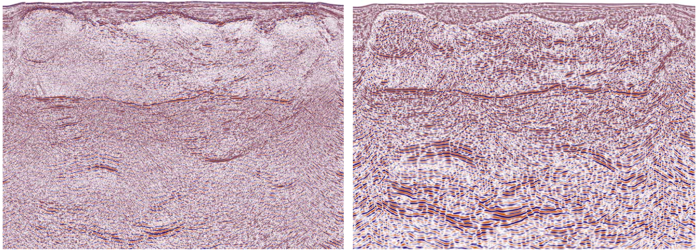
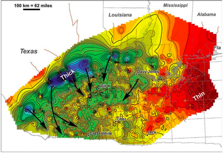
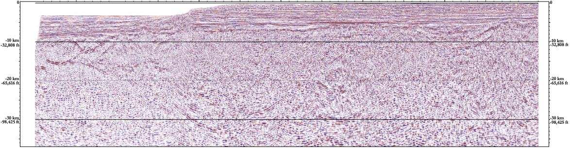
RTM re-processing gives a new look at the Gulf of Mexico Continental Margin. The GulfSPANTM data illuminates the geology of the northern Gulf of Mexico Basin, all the way from onshore to deep water. The GulfSPAN kmTM data illuminates the geology of the northern Gulf of Mexico Basin, all the way from onshore to deep water. ION’s GX Technology is a leader in offering basin-wide regional, long-offset seismic data to the oil and gas industry. The GulfSPANTM data, part of ION’s world-wide BasinSPANSTM programs, is a unique dataset that does not exist on any other continental margin. It ties the northern Gulf of Mexico Basin west to east, from onshore to deep water. The 2011 era for basin-scale imaging in the northern Gulf of Mexico is highlighted by the recent release of the newly reimaged streamer/OBC PSDM (RTM) seismic data in the GulfSPAN project. The upcoming FloridaSPANTM survey ties in existing GulfSPAN data, thereby extending the regional framework from West Texas through Alabama to Florida. This regional PSDM dataset has been reprocessed utilizing ION GX Technology’s Reverse Time Migration (RTM) methods and enhanced deep-imaging techniques, integrating gravity, magnetic and well data. The data have been re-interpreted with an improved well database. Additional well control for top and base salt aided the interpretation and guided the velocity model-building. This effort involved multiple processing iterations examining the effect of the salt velocities on imaging deep strata below the salt canopies. Ocean bottom cable (OBC) and streamer data were merged and reimaged to develop a basin-wide velocity model in order to produce a regionally consistent grid. The seismic lines extend onshore and can be seen on the foldout to link prograding shelf margins in Cretaceous and Tertiary strata to their coeval basin floor sediments in deep water. Legacy (onshore) data were reprocessed to create a regional grid of PSDM data that tie the down-dip OBC and streamer data. Additional onshore surveys are currently in production, extending original dip lines tied to regional composite strike lines that follow the Jurassic, Cretaceous, Eocene, Oligocene and Miocene shelf margins. The original regional framework was re-interpreted, refining the horizon and fault interpretations and re-examining the linked (both extensional and compressional) fault and fold systems. These fold systems are developed in the western and east-central protraction areas and have undergone translation along multiple detachment surfaces since the Mesozoic Era. A regional Eocene to Oligocene salt canopy was loaded by Oligocene and Miocene prograding delta systems, creating a regional salt weld surface that is clearly delineated by the new GulfSPAN data. Neogene contraction appears to have occurred in the central western Gulf of Mexico, resulting in the squeezing of pre-existing salt stocks and deflation of salt sheets. A number of additional salt weld surfaces are also imaged on the new data. Salt canopies are an indirect indicator of contraction related to up-dip extension. Deep synclines and expanded sections of younger sediments fill the depositional basins as the salt evacuates. Above the salt canopy condensed Mesozoic to Tertiary sediments have been drilled and demonstrate the existence of older salt stocks that rafted sediments into their present-day supra-salt position. Regional isopach maps created from these data identify potential depositional fairways and structural timing of depositional events. These new insights will guide existing exploration play models and help identify new play fairways in the northern Gulf of Mexico. A key component to ongoing exploration success is the quality of subsalt seismic images. Uplift from RTM over conventional Kirchhoff migrations give geoscientists a new look at many areas that were previously poorly imaged, particularly for deeper subsalt sediments. The deeper potential of previously explored areas may result in the identification of new plays and consequently in new discoveries. Similarly, preliminary imaging of the eastern part of the basin in Florida has illuminated potential in older Mesozoic strata, potential targets in the pre-salt section and a better understanding of crustal architecture in this area, as seen in the north-east to south-west regional dip line from the FloridaSPAN data. Successful exploration strategies for the future will require a basin-wide perspective and a fundamental knowledge of how these various factors affect the development of the Gulf of Mexico petroleum systems.
The only complete regional perspective

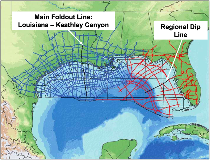
Inset base map shows the location of seismic profile and the complete GulfSPAN program. Red lines in the eastern Gulf of Mexico and onshore Florida are the recent continuation of this pro- gram to better understand the northern and eastern margins of the basin. Some of these lines have already been acquired and processed and some are in the planning stage.
A unique basin-wide dataset
Regional framework re-interpreted
Related Articles


