The Next Global Frontier
The Arctic is the next, and maybe the most challenging, global frontier – but how can it be effectively explored with only a two-month ice-free season?
“The Arctic is surely the next large global frontier, but it is going to take time and effort to effectively explore,” says Joe Gagliardi, Director for Arctic Solutions and Technology for seismic solutions company, ION Geophysical. “For some time, we have been working to help companies understand this vast area and assist them with their strategic analyses. But to do that, we need to fill the exploration time gap. If we are to take Arctic exploration further, we can’t rely on the limited period of open water in these frozen seas – one to two months at the most. We have to rethink and modify our methods of marine seismic data acquisition.”
To better understand how to operate in this extreme environment, from 2006 to 2008 ION worked in the Arctic Beaufort and Chukchi Seas. “Technologically, the challenge has been to develop seismic methods that work in and under the ice,” explains Joe. “This has also given us a great opportunity to understand the additional factors involved in Arctic exploration – geopolitics, working with local communities, ensuring the welfare of marine mammals, and many other dynamics that need to be addressed when planning programmes in this complex arena.”
“Those three years of investigation gave us the knowledge and confidence to develop a purpose-built solution for acquiring seismic data in the ice for up to nine months of the year, depending on which Arctic basin we are focusing on. We have combined our operational experience with purpose-built seismic equipment and Arctic-focused imaging algorithms.”
Complex Challenges
 The HMS Investigator made two voyages to the Arctic in the 1850s and had to be abandoned in 1853 after becoming trapped in the ice in the notorious McClure Straits. Her wreckage was found in July 2010, shortly before ION commenced the first ever seismic survey in the area. Image: National Archive of Canada“In 2009, we became the first company to shoot long offset seismic under the ice. To do this requires a very stable acquisition platform with no surface features,” Joe continues. “That includes no gun floats or tail buoys. Solving these mechanical issues, however, leaves us with complex noise events, very different from those seen in open water. For example, when operating in the Arctic, an ice breaker vessel sails the line just ahead of the seismic boat clearing its path and, as you can imagine, the noise created sets up some very complex reflections. Completely new algorithms were built and have been incorporated into the processing system in order to deal with this and similar issues. However, from the point of view of the end user, the data looks the same as that acquired from more conventional areas – but considerably better than any previously obtained in this area.”
Developing ION’s Intelligent Acquisition [IA]TM Arctic Solution required collaboration across all the business units within ION, including its GX Technology (GXT) data processing group and its Marine Imaging Systems Division, which makes the streamers. Within ION there are also in-house scientists who specialise in forecasting Arctic ice conditions and regional experts who help create the ideal survey designs for positioning and shooting long seismic lines in these extreme conditions.
“We believe we have amalgamated the best expertise in the world for this niche market,” Joe adds. “By having an icebreaker precede the seismic vessel, long straight lines can be the shot. We are now obtaining high quality long offset data that is beginning to unlock the exploration potential of previously underexplored basins.”
Risks Reduced
 Joe Gagliardi is ION Geophysical Corporation’s Director of Arctic Solutions & Technology, where his focus is on the development of proprietary solutions (equipment & procedures) for the acquisition of Multi-client and proprietary seismic surveys in the global Arctic region. He is a graduate of Rice University’s Executive MBA program and holds a B.S. in Geological Oceanography from Florida Institute of Technology.
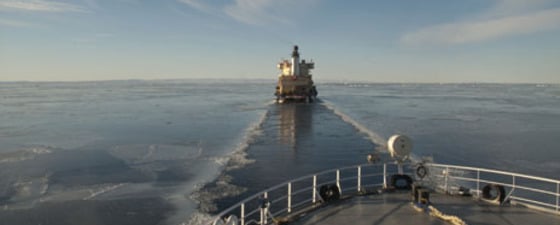
 MV Geo Explorer working in the ice in the Arctic Photo: IONJoe Gagliardi points out that the IA Arctic Solution that ION has devised can significantly reduce key risks in Arctic exploration. “These systems lessen operational risk by giving companies the ability to conduct seismic exploration in transitional ice regimes without concern for the disposition of first year ice,” he explains. “We have been able to expand the operational window in the Chukchi Sea, an area with an estimated 29 Bboe of recoverable reserves, from just two months, July and August, to five or six months, working right into November or even December.”
“This also means that we can conduct seismic operations in environmentally sensitive areas after the ice has begun to form, when many protected species have completed their summer activities and are moving away to warmer areas, and also without interfering with the summer prime hunting season for the indigenous people.”
“Technical risk is also reduced. We have had very little technical downtime during our Arctic surveys, usually something in the order of only 2%. Average seismic vessel downtime in the industry is 7 – 10%.”
Virgin Territory
Since 2006, ION has shot about 45,000 line kilometres of seismic data in the Arctic, covering waters belonging to Greenland, the US, Canada and Norway. Much of this is in areas where there was either no seismic data, or the quality was too poor to be used for exploration purposes. In 2010, two crews worked the Arctic using the [IA] Arctic Solution, producing excellent images of the sub-seabed in Northeast Greenland and the Canadian Beaufort Sea and McClure Straits. The latter is particularly virgin territory, having ice conditions that stopped the SS Manhattan in 1969, and was the final resting place for the HMS Investigator in 1853.
The results of ION’s Arctic surveys have been combined in its ArcticSPANTM multi-client data program that covers the Beaufort-MacKenzie, Banks Island, Chukchi, East Greenland Rift, and Danmarkshavn basins. The program gives geoscientists a basin-level tool for interpreting new petroleum systems in the offshore Arctic region. Joe and his colleagues believe that such basin-wide studies will help exploration companies to focus their resources, as the lines transect key geological features and also wells, where present, to place the geology in a basin-wide context.
Production in Ten Years?
With an estimated 90 billion barrels of oil and possibly a third of the world’s undiscovered gas reserves, the Arctic is heating up for oil and gas exploration, and is surely the next, and possibly the last, great frontier region. With so little good quality seismic data available, oil companies need all the help they can get to evaluate this fascinating but challenging area.
“Companies love the data they can get from our new under ice acquisition techniques,” Joe says. “But exploiting this area will not be rapid; we estimate that it will need significant investment now on the part of the oil companies, in order to see production in ten years time.
“We believe that by obtaining high quality data over a longer annual survey period, companies can move closer to achieving the goal of producing oil and gas from the Arctic waters,” says Joe.