The King of Giant Fields
Since the petroleum industry began in the mid-nineteenth century, numerous oil fields have been discovered and over 70,000 oil fields are still in use. Nonetheless, not all fields were created equally.
Publications by the American Association of Petroleum Geologists over the past three decades have identified 500 to over 900 oil fields as world-class “giants;” those with proven oil reserves of 500 million barrels or natural gas reserves of 3 trillion cubic feet. A “supergiant field” is one with 5 Bbo (or oil equivalent) reserves. Despite their relatively lower population, the giant fields account for over half of the world’s oil resources. Their distribution, however, is uneven; over 200 of them are concentrated in the Persian Gulf region. Giant fields are hard to come by, and the life span and reservoir management of these fields will have a drastic impact on the global oil industry and market in the coming years. Starting with this issue, Geo Expro will occasionally present reviews on the world’s giant oil and gas fields. And it is apt to begin the series with the world’s largest of its kind – the Ghawar field in Saudi Arabia.
Discovered in 1948 and located some 200 km east of Riyadh, Ghawar has produced about five million barrels of oil per day in the past three decades. Last year, output from Ghawar accounted for 62.5% of Saudi Arabia’s crude production (about 8 MMbopd) and 6.25% of the world’s total oil production (about 80 MMbopd).
 A historical photo showing the exploration of the Ghawar field in the late 1940s. Photo courtesy of Saudi Aramco CoThe Ghawar field is located in Khobar County in the Eastern (Al Hasa) Province; it is about 100 km southwest of Dhahran (Saudi Aramco’s headquarters). The field is an almost north-south trending structure, 280 km long and 30 km wide on average, totaling an area of 5,300 km2 – about one fourth the size of Wales or New Jersey. Of course, not the entire field is productive; Alsharhan and Kendall in their 1986 paper in AAPG Bulletin give a figure of 2,800 km2 for the productive area of Ghawar.
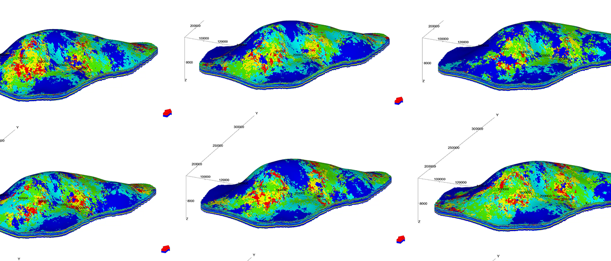
The field is divided into six parts, corresponding to prominent structural culminations; from north to south they are Fazran, Ain Dar, Shedgum, Uthmaniyah, Haradh, and Hawiyah. Because of secrecy over data held by Saudi Aramco, detailed information about the Ghawar field is not available in the public domain; one thus has to piece together data from the official reports or published research works to characterize the geology, reserves and production history of Ghawar.
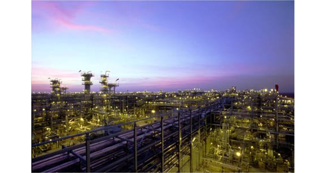
A view of the Haradh gas-oil separator plant shows the extent of this giant field. The plant went onstream in 2003, Saudi Aramco’s second plant to process non-associated gas. It is designed to process 1.6 Bcfgpd from wells in the South Ghawar and produce 1.5 Bcfpd of sales gas and 170,000 bpd of condensate. Photo courtesy of Saudi Aramco
Field Discovery: The Magnificent Five
The discovery and development of the Ghawar field dates back to the 1940’s and 50’s, when the Standard Oil of California (Socal, forerunner of Arabian American Oil Company, later Saudi Aramco) obtained concessions from the Saudi government for oil exploration in the kingdom. These activities resulted in the discovery of Dammam in 1938, and Abu Hadriayh and Abqaiq in 1940 (see “The Emergence of the Arabian Oil Industry”).
A structural transect across the Ghawar field (Modified after A.M. Afifi, 2004 AAPG Distinguished Lecture).
 In 1940, while the company was drilling the Abqaiq prospect, one of its young geologists, Ernie Berg, was mapping the nearby areas and noted that the Wadi Sahaba, a dry river bed in the Haradh area, took a sudden bend from its east-west course to the south. He hypothesized that a north-south trending subsurface anticline was responsible for this wadi diversion. His boss, the renowned geologist Max Steineke, agreed with the idea. Further mapping confirmed the existence of what came to be called the En Nala (“the Slippers”) anticline. What made mapping this anticline possible was shallow structural-stratigraphic drilling, down to about 300m in the desert, a technique Steineke had developed to map the subsurface geology and collect pre-Neogene information in the region.
 World War II hampered all these activities, but once the war ended in 1945 and exploration resumed the En Nala anticline drew attention again. Shallow drillings were supplemented with gravity and magnetic surveys. In 1948, a test well was drilled at Ain Dar, which hit oil, the first post-war discovery in the country. Steineke then proposed a second drill site at Haradh, about 185 km south of Ain Dar. This wildcat also discovered oil in 1949. Then came Uthmaniyah No. 1, drilled in 1951, Shedgum No. 1 (1952) and Hawiyah No. 1 (1953), all of which discovered oil from the same Upper Jurassic carbonate reservoir at depths of 2,000-2,330m along the same anticline. By 1953, it was recognized that all these prospects were parts of a single field that was named Ghawar, after the pasturage area the local Bedouins originally called Al Ghawar. (Some geologists argue that these structural culminations are separate fields, but here we follow the conventional history and regard them as parts of the Ghawar supergiant field).
An article in the 2008 fall issue of the Saudi Aramco Dimensions magazine provides valuable information about these five discovery wells dubbed by the authors of that article as “The Magnificent Five” (see Table 1). Except for the Uthmaniyah No. 1, the other discovery wells are still productive.
The northernmost part of the Ghawar field, Fazran, was found in 1957 to have oil in the same reservoir, but our knowledge of this area remains quite limited.
Structural Setting
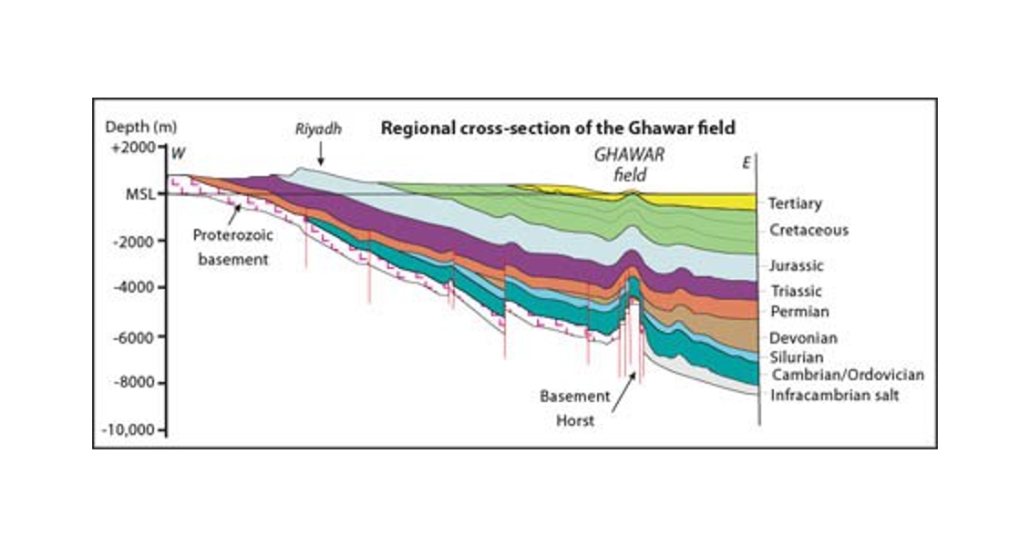
 Stratigraphy of the Jurassic petroleum system in Ghawar.The En Nala anticline, on which the Ghawar field sits, is located within the Central Arabian graben. Drilling and seismic images show that the anticline (trending N15° E) itself sits on a basement horst formed during the late Carboniferous-Permian extensional tectonics and block uplift, probably related to continental rifting along the Arabia-Gondwana margin and opening of the Neo-Tethys Ocean. This basement horst was reactivated as a compressional structure during the Late Cretaceous, and the compressional stress has continued in the Cenozoic as the Arabian plate collided with Asia. Interestingly, the basement horst forms a divide between the Infracambrian salt deposits on its east and the Precambrian metamorphic rocks (devoid of the salt layer) on its west; therefore, the activity of the structures probably dates back to the Late Proterozoic “Pan African” extensional tectonics.
The southern part of the En Nala structure is a relatively simple anticline with shallow (3-8°) dipping flanks; the anticline is asymmetrical having a steeper western flank. To the north, the structure becomes more complex.
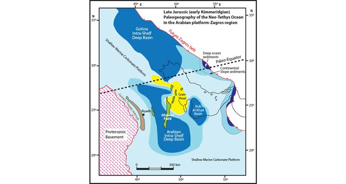
Late Jurassic paleogeography showing the Ghawar field on the Arabian carbonate platform (Modified after Lindsay et al, AAPG Memoir 88, 2006)
Major Jurassic Reservoir
The Ghawar area is largely covered with Miocene-Pleistocene continental sediments except for two small Eocene outcrops. The Tertiary and Cretaceous rocks have not yielded oil accumulations in this field; the producing reservoir is the Upper Jurassic Arab formation which is a major oil reservoir in the Middle East. The Arab-D reservoir in Ghawar includes the lowermost zone of the Arab formation and the uppermost part of the Jubaila formation. It is carbonate rock of Kimmeridgian age, as determined from its ammonite and benthonic foraminifer fossils, deposited on the shelf of the Neo-Tethys Ocean. The Ghawar area then lay about 5° south of the equator. The Arab and Jubaila formations are 186m and 400m thick, respectively, in Ghawar. The producing interval has been reported to be 50-100m.
 Sedimentologists have further divided Arab-D carbonates into six lithofacies units, with the transition from the Jubaila to the Arab formation lying at Unit 2B, marked by karst-collapse breccias. Overall, the Arab formation sequence of the Arab-D reservoir consists of grainstones and packstones while the underlying Jubaila formation part is limestone and mudstones. The reservoir has retained good porosity, averaging 15%, in the form of interparticle, intraparticle and moldic pores. Fractures and interparticle pores provide the reservoir’s permeability. Dolomites also occur in Arab-D, and were probably formed by downward flow of magnesium-rich brines during deposition of Arab C and D anhydrites on the top. It has been recognized that units 2A and 2B of Arab-D are occasionally very high permeability zones (or “Super-k” intervals which intersect wells producing over 500 barrels per day per foot) and that such zones are associated with dolomites. Probably the process of dolomitization helps fracturing of the rock. For this reason, the characterization and mapping of dolomites in Arab-D has attracted much research work.
Available data from the discovery wells (Table 2) indicate that the reservoir quality of Arab-D becomes relatively poorer from north to south as reservoir thickness, porosity and permeability are progressively reduced; oil quality also appears to change as sulfur content and oil density increase.
Oil from Ghawar has a density of 30-34° API. The oil column in the field has been reported to be 396m. The oil-water contact in North Ghawar is about 137m deeper than in South Ghawar; this northward tilting of the oil-water contact has puzzled researchers for decades.
Oil is believed to have charged from the organic-rich, thermally mature bituminous carbonates and mudstones of the Hanifa and Tuwaiq formations (Upper Jurassic age). Anhydrites of Arab-D and C, with a thickness of 30-100m, provide cap rock for the accumulated oil in Arab-D.
Palaeozoic Gas
 Stratigraphy of Paleozoic gas systems in Ghawar.Deeper drilling in the Ghawar field has discovered vast amounts of natural gas in the Palaeozoic sediments. These discoveries were made in 1971 (Haradh), 1975 (Ain Dar), 1979 (Hawiyah and Shedgum) and 1980 (Uthmaniyah). In 1994, Saudi Aramco began a vigorous plan for deep gas exploration including prospects in Ghawar.
The gas reservoirs include the Khuff Formation (Permian carbonates), the Unayzah Formation (Permo-Carboniferous fluvial-aeolian sands), and the Jauf Formation (Devonian coastal to shallow-marine sands). The payzones lie at depths of between 3,000 and 4,270m. A Silurian black shale (“hot shale” on gamma logs) called the Qusaiba Formation constitutes a major source rock for the Palaeozoic gas accumulations in the Ghawar field, as it does in other fields of central Saudi Arabia. This shale was deposited during a major sea-level rise in the Silurian.
According to Afifi (2004), gas production from Ghawar totals about 8 Bcfgpd, out of which 2 billion is associated gas and 6 billion is non-associated gas.
How much oil in Ghawar?
 Oil production of Saudi Arabia (total) and the Ghawar field and the percentage of water cut in Ghawar 1993-2003. Ghawar production accounts for over half of annual Saudi crude. Water cut is the ratio of water to total liquids production from an oil field; in water-driven mature reservoirs water cut can reach up to 80-90 %. (Modified after A.M. Afifi, 2004 AAPG Distinguished Lecture; total oil production from BP Statistical Review of World Energy)No one exactly knows how much oil lies beneath Ghawar. Some estimates (World Energy Outlook, 2005 and 2008) put the oil in place as high as 250-300 billions! However, simple calculations using the reservoir volume, porosity, and water saturation for all the five areas of Ghawar (Table 2) would give the maximum amount of oil in place at about 190 Bbo. How much of this oil (if true) is recoverable is another story. Total recoverable oil reserves from Ghawar have been reported variously as 75 Bbo (Halbouty et al., 1970, AAPG Memoir 14), 68-46 Bbo (Oil & Gas Journal issues 1973-77), 80.3 Bbo (Beydoun, The Middle East, 1988), 66 Bbo (Mann, 2003, AAPG Memoir 78), and 140 Bbo (World Energy Outlook, 2008). The latter source places the natural gas reserves of Ghawar at 186 Tcf, thus giving combined reserves of 97 Bboe.
Beydoun in his book (The Middle East, 1988) reports that Ghawar had produced 19 Bbo by 1979. According to an article on Ghawar in the AAPG Explorer (January 2005), the cumulative production from the field was 55 Bbo. The International Energy Agency in its 2008 World Energy Outlook states that the oil production from Ghawar reached 66 Bbo in 2007 and that the remaining reserves are 74 Bbo.
Data on Ghawar reported in the past issues of Oil & Gas Journal indicate that when Ghawar came on stream in 1951 it produced 126,000 bopd but production steadily rose with a major boost soon after the 1973 oil shock so that the field’s 1975 output was 4.2 MMbopd; this reached a maximum production of 5.7 MMbopd in 1981. From 1982-1990, the Saudis lowered their oil production for market considerations (most notably the oil crash of 1985) and thus Ghawar’s production was 2.5 to 3 MMbopd during that decade. A senior geologist with Saudi Aramco, A. M. Afifi, in his 2004 AAPG Distinguished Lecture, reported production values of 4.6-5.2 MMbopd for Ghawar from 1993 through 2003. These data indicate that 50-65% of Saudi Aramco’s oil production has traditionally come from Ghawar. Apparently, one half of Ghawar’s production (2.0 to 2.7 MMbopd) comes from the Ain Dar and Shedgum areas, while Uthmaniyah provides 1 MMbopd, and another million barrels or so comes from Hawiyah and Haradh combined.
Compared to the supergiant size of Ghawar, our public knowledge of this field remains insignificant. Oil fields, whether small or large and wherever they happen to be located, eventually come to an end, but giant fields have enormous life spans.