Prolific Miocene Trend Hurt by Blowout
Miocene deep water sands were the target for the Macondo well in Mississippi Canyon Block 252, and it is probably from one of these sands that the blowout originates.
The recent blowout of an exploration well on April 20 on BP’s Macondo Prospect in Mississippi Canyon[1] Block 252 has attracted media attention for the potential environmental consequences of the incident. The well is located in the northeastern part of the Gulf of Mexico, approximately 85 km (52 miles) southeast of the bird’s foot delta of the Mississippi River.
The Mississippi Canyon protraction area is one of the most prolific sectors of the Gulf of Mexico outer continental shelf (OCS), being home to many producing fields, including BP’s deep water Thunder Horse field, a world-class giant with capacity to produce 250,000 bopd through the world’s largest semisubmersible production-drilling-quarters (PDQ) facility in 1844 m (6050 ft) of water in Mississippi Canyon Block 778.
The production facility nearest to Macondo is Shell and BP’s Na Kika complex, located in Mississippi Canyon Block 474 approximately 25 km (15 miles) south-southeast of the blowout. The Na Kika facility is the collecting point for six (originally five) separate fields that produce both oil and gas from Miocene deep water sands. This facility, which is a semisubmersible host permanently moored in 1935 m (6350 ft) of water, is designed to recover up to 300 MMboe from its contributing fields.
The mega-regional geologic history of the Gulf Coast basin has been controlled through time by the close interaction of sedimentation and salt tectonism in an overall extensional setting. Within this setting the intensity of deformation in the northeastern portion of the basin has been relatively low. In contrast, in the central and western parts of the basin the Tertiary section is much thicker and the structural complexity is greater, including stacked salt sheets and welds, large listric growth faults, and compressional folds and reverse faults at the downdip toes of major extensional fault systems.
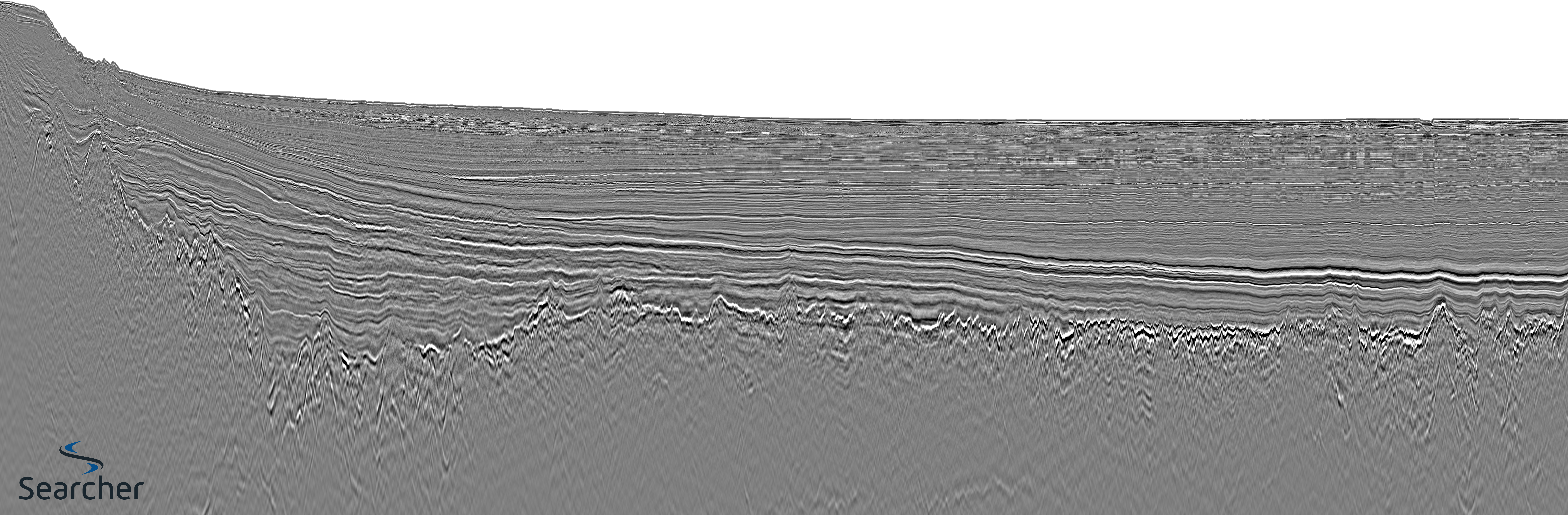
The 2D seismic line, due south of the Macondo prospect, traverses through one of the Na Kika fields and clearly shows features that are typical of the extensional structural style related to basin formation and the movement of salt in response to sediment loading in this part of the Gulf of Mexico.
Immediately following rifting of continental crust in Early-Middle Jurassic time, the so-called “post-rift” Middle Jurassic Louann Salt was deposited unconformably on Lower Jurassic – Triassic (?) “syn-rift” sediments in the nascent Gulf Coast basin. This salt was mobilized by subsequent sediment loading beginning in Late Jurassic time and continuing intermittently through to the present day.
A distinctive sea-floor signature of bathymetric highs has resulted (see bathymetric map), corresponding to individual shallow salt bodies that have not coalesced to form large salt sheets or canopies as has occurred farther to the west. The sea-floor expression of shallow salt bodies (highlighted in red) is also evident at both ends of the seismic line.
The pronounced syncline evident in the center of the seismic line separates two so-called “turtle” structures that formed in response to withdrawal of the Louann Salt in Late Jurassic – Early Cretaceous time (hence the expanded Upper Jurassic – Lower Cretaceous section annotated on the line).
The thick Miocene section above the “Top of Lower Tertiary Carbonates” reflection contains the reservoir sands that are producing in Na Kika and other fields in the area. Miocene sands also were the targets on Macondo, although it is not known how these sands, including the one from which the blowout originated, correlate to nearby producing Miocene reservoirs.
Plio-Pleistocene sediments are relatively thin in this part of the Gulf of Mexico, but thicken markedly to the west where they serve as excellent reservoirs in major oil and gas fields.
[1] The Mississippi Canyon is an undersea canyon south of Louisiana. With an average width of 8 km and a length of 120 km it is the dominant bathymetric feature of the north-central Gulf of Mexico.