Miri 1910
In 1910, now 100 years ago, the Shell/Royal Dutch Group drilled the first discovery well in Miri, Sarawak. This oil discovery changed the face of Miri from a small fishery village into a modern city. But it took a lot more than luck to find and produce Sarawak’s only onshore oil field.
Sarawak is located on the northwest coast of Borneo, the world’s third largest island. It is rich in natural resources; indeed the word “serawak” is a Malay word for the mineral antimony. Paleolithic cavemen and hunter-gatherer tribes first settled in Sarawak; the oldest evidence includes a Homo sapiens skull in the Niah Caves near Miri estimated to be 35,000 years old. Then about 4,500 years ago waves of Austronesians, the ancestors of the present Dayak peoples, came to this region. Chinese and Malay traders visited Sarawak as early as 900 A.D., brining Buddhist, Hindu and Muslim traditions to Borneo. The Europeans came in the 16th century. In 1512, Antonio Pigafetta, an Italian companion and chronicler of Ferdinand Magellan, wrote an account of the region, or what he called “Cerava.” In the 1820s, Dutch colonialists began to exert their influence in Kalimantan, the southern part of Borneo.
The modern history of Sarawak began in 1839 when James Brooke arrived in Sarawak. Brooke was born in 1803 in India and was an army officer of the British East India Company. Upon his father’s death, James quit his job and used his inheritance to purchase a schooner, the Royalist, and sailed for Sarawak. There he met with Rajah Muda Hashim, who was governing the region on behalf of his nephew, Sultan Omar Ali Saifuddin II of Brunei. As Brooke’s party left Sarawak for Singapore, Dayak pirates unsuccessfully attached his ship. In 1840, Rajah Muda Hashim requested Brooke’s help to defeat a Dayak revolt in Kuching, promising in return to give him Kuching and enviros (later called the First Division of Sarawak). Following this success, Brooke was appointed the first White Rajah of Sarawak in 1841in exchange for a small annual payment to the Sultan of Brunei. Initially the British were not supportive of Brooke, but after Brooke began to eradicate piracy in South China Sea, and in 1846 the Sultan of Brunei ceded the nearby island of Labuan to the British Royal Navy as a base for fighting the local pirates, relationships between Brooke and Britain were cemented.
Motivated by Oil Seeps
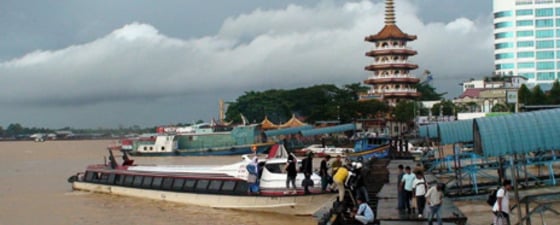
 A view of Miri coastal town and South China Sea. Photo: Rasoul SorkhabiThe first geological survey of Sarawak was conducted by Hiram Williams in 1845. Sarawak was also part of Alfred Russel Wallace’s natural history exploration from 1854-1862, which is recorded in his book The Malay Archipelago (1869). Wallace refers to coal mines in Sarawak: “These [coal mines] puzzle the natives exceedingly, as they cannot understand the extensive and costly preparations for working coal, and cannot believe it is to be used only as fuel when wood is so abundant and so easily obtained.” The Italian biologist Odoardo Beccari also explored Sarawak from 1865-68, documented in his Nelle Foreste di Borneo (1902; Wanderings in the Great Forests of Borneo, 1904).
The Brooke administration was in business engagements with companies in Scotland and Singapore. To better facilitate trade between Sarawak and Britain, the Borneo Company Limited was founded in London in 1856. In the following decades, surveyors working for this company carried out extensive mapping of Sarawak for its mineral and natural resources. (Henry Longhurst details this history in his 1957 book, The Borneo Story: The First Hundred Years of the Borneo Company.)
In 1864, Britain recognized Sarawak as an independent state. In 1868, James Brooke was succeeded by his nephew Charles Johnson (later renamed Brooke), who ruled Sarawak until 1917 and, over time, extended his domain to the present boundaries of Sarawak. In 1888, the White Rajah obtained British protection for Sarawak. During Sir Charles Brooke’ period surveys and exploration in Sarawak increased. Dr. T. Posewitz published Borneo: Its Geology and Mineral Resources (London, 1892), and Henry Ling North produced a comprehensive description of The Natives of Sarawak and British North Borneo (London, 1896).
Like the other oil regions of the world, oil seeps provided the first motivation for drilling in Sarawak. Indeed, local inhabitants had extracted oil from hand-dug wells for centuries. The 11th century Song Hui Yao, a historical compilation of the Song Dynasty of China, mentions imports of Borneo-camphor and petroleum. In 1882, Claude Champion de Crespigni, Resident (chief officer) of the Fourth Division (Baram), listed in his report to the Brooke Government 18 hand-dug oil wells in the Miri area. Perhaps foreseeing the value of what the locals called “minyak tanah” or “earth oil,” De Crespigni recommended in his 1884 journal that “the oil district near the mouth of the Miri River should be thoroughly searched and reported on.” “Earth oil” was used by local people for lighting lamps, waterproofing boats, and medicinal purposes. But De Crespigni’s words fell on deaf ears in the Brooke government.
Enter Charles Hose
 Dr. Charles Hose (1863-1929), a British colonial officer at the service (1884-1907) of Rajah Charles Brooke in Sarawak and a pioneer explorer whose effort and vision led to the discovery of the Miri oil field in 1910. He was a member of the Supreme Council of Sarawak from 1904 and a member of the Sarawak State Advisory Council (based in Westminster, England) from 1919. A Fellow of the Royal Geographical Society, the Zoological Society, and Jesus College, Hose authored several important works on the natural history and ethnology of Sarawak, including The Pagan Tribes of Borneo (1912) and The Field Book of a Jungle-Wallah (1929). Illustration: Setsuko YoshidaCharles Hose was born in Hertfordshire, England in 1863. He entered Jesus College, Cambridge in 1884; but two years later without completing his studies, the young Hose (with help from his uncle, the Bishop of Singapore) took up an administrative cadetship in Sarawak. Hose resided at Claudetown (today’s Marudi), and in 1888 he succeeded de Crespigny as Officer-in-Charge, and in 1890 as Resident of Baram.
Hose, a keen natural historian and explorer, picked up de Crespigny’s oil idea and began mapping of oil seeps in and around Miri. He even offered awards to the locals who would show him an oil seep. Hose reported his findings to the Brooke government, but a consultant geologist from England gave a negative opinion of oil exploration in Sarawak because of poor logistic conditions.
Hose kept the oil idea in the back of his mind. After serving as Resident of Sibu (the Third Division of Sarawak) from 1904-07, he retired and returned to England, where the aging Rajah Sir Charles Brooke was then staying. Hose wrote to the Rajah seeking his permission to show his map of the oil seeps and the Miri oil samples to a petroleum company. After obtaining the Rajah’s permission, Hose went to London to discuss his idea with the Anglo-Saxon Petroleum, a part of the Royal Dutch/Shell Group (formed in 1907). Mr. H.N. Benjamin and his colleagues at the company were interested in the idea, and the Rajah thus came to London to sign the first Sarawak Oil Mining Lease in 1909.
Shell and the Discovery Well
 A map and geologic cross-section of the Miri field,originally drawn by the Sarawak Shell geologist P. von Schumacher in 1941 and revised by other geologists since then. Illustration: Rasoul Sorkhabi
 Drilling Miri Well No. 1 in 1910Drilling Miri Well No. 1 in 1910 Shell dispatched their senior geologist Dr. Josef Theodor Erb (a Swiss geologist who had joined the Royal Dutch in 1900) along with Hose to Miri. They traveled on the Trans-Siberian railway and by boat, arriving in Kuching and calling on the Rajah, before proceeding to Miri. Erb started an independent examination of the Miri area, mapping several anticlines including his favorite “Miri Hill,” a northwest-dipping asymmetrical anticline, with nearby oil seeps. In July 1910, Erb reported to the company his final geological map of the Miri area, and located the first exploratory well at the crest of the Miri anticline about 150 m above sea level. This surprised people who had anticipated the well to be drilled in an oil seep like all the previous hand-dug wells. Before the drilling could begin, Erb and Hose had to convince the local people that the well would not open the underground cave that was, according to a local legend, home for two evil tigers.
The well was spudded in on 10 August 1910 using a rig composed of wooden derricks and the cable tool drilling (a technology that dates back to the Chinese in the fifth century for drilling for brine). The rig was engineered by a Canadian, Mr. McAlpine; therefore, the hill has been historically called the “Canada Hill.”
On 22 December 1910, the well struck light crude at 425 ft (130 m) depth. The reservoir was Upper Miocene deltaic sandstone beds deposited by the ancestral Baram River. Initial production was only 83 barrels oil oil per day (bopd); after production reached 227,000 bopd averaged over the year, the well was deepened to 1,096 ft (Miri-2 drilled in 1911 was dry, but over time, numerous other wells (many deeper) produced from various payzones in the field.
The Sarawak Oilfield Ltd., a subsidiary of the Shell/Royal Dutch Group, was established to run the Miri operations (this company is now called Sarawak Shell Berhard, located in Lutong, on the outskirts of Miri). Most of the labor force to work in Miri came from Singapore.
The 1910 discovery well was to change the face of Miri, or as Hose put it his 1927 book Fifty Years of Romance and Research or a Jungle-Wallah at Large: “An area which was almost uninhabited was now a center of bustling life.”
The Rise, Fall and Rise of the Miri Field
 An outcrop of the Upper Miocene Miri Formation in the town of Miri showing cross-bedding in the deltaic sandstone. Photo: Rasoul Sorkhabi
 Stratigraphy of producing zones in the Miri oil field (modified from The Petroleum Geology and Resources of Malaysia, Petronas, 1999) Illustration: Rasoul SorkhabiOil production from the Miri field rose from 5 bopd in 1911 to 523 bopd in 1913 (from eight wells), when Shell also began to export the Miri oil. The following year oil production reached 1315 bopd and further increased to 11,210 bopd in 1923.
In 1914, Sarawak Shell built the first refinery in Miri (it was relocated two years later to Lutong). Also in the same year, Shell laid a submarine pipeline from Tanjong Lobang (south of Miri) to transport the crude to an offshore loading berth and tankers. The sealine was about 2.5 miles long and six-inches in diameter. During World War I (1914-18), the Miri field provided 5763 bopd averaged over the year to the British Navy.
In May 1917, Sir Charles Brooke died and his son Charles Vyner deWindt Brooke became the Third White Rajah of Sarawak (he was knighted in 1927). Hose, who lived in England, received a royalty on oil production from Miri, considerable revenue for the rest of his life. He also gave lectures and published works about the natural history and culture in Sarawak. (For his scholarly works, Cambridge awarded an honorary doctorate to Hose in 1900.) He died in 1929. Several species discovered from Borneo have been named after him. As for Dr. Josef Erb: After the Miri field discovery, he continued his work for Shell in other parts of the world; he died in 1934 at the age of 60. Another Shell geologist who made significant contributions in the 1930s to the geology of the Miri field was P. von Schumacher.
Shell introduced rotary drilling in the Miri field in 1925. Peak production reached 15,211 bopd in 1929. By the end of 1940, the Miri field had produced 7 million barrels of oil and a total of 597 wells had been drilled in the field. And by then, Miri’s population had grown to 11,000, of whom nearly two-thirds were of Chinese ethnicity.
In 1941, during the heyday of World War II, the Brooke government obtained military help from Britain: Over 1,000 soldiers (the so-called 2/15th Punjab) under the command of Major C.M. Lane were stationed in Miri to protect the oil field. Anticipating the Japanese invasion, they eventually shut in the Miri wells and the Lutong refinery, and sent the equipment, skilled workers, and documents to Singapore. This was part of the Allied forces’ Denial Scheme. On 19 December 1941 (only nine days after the Perl Harbor attack), a ten-thousand-strong Japanese army occupied Sarawak following two days of fighting with a small garrison of Dutch troops. This virtually ended the Brooke dynasty’s hold on the region.
Within two months of their occupation, the Japanese were able to retrace the equipments and men in Singapore and bring them back to Miri. Thus a new Japanese company, Nenryo Haikyu-sho (“Oil Supplying Services”), took over the operations in Miri and produced nearly 750,000 barrels of oil for the Japanese army during World War II. (Of this volume, Miri Well No. 1 produced 4,371 barrels.) When the war ended in September 1945, Miri had suffered severe damage and destruction, mainly from the Allied forces’ bombings (part of the Denial Scheme). The Third White Rajah returned to Sarawak in 1946 but decided to give the country to the British Crown. In 1947, attempts were made to reconstruct and reproduce oil from the Miri field.
1960s: Offshore Sarawak and Joining Malaysia
 An outcrop of the Upper Miocene Miri Formation in the town of Miri deposited by the paleo-Baram Delta. The human scale in the photo is the author of this article. Photo: Rasoul SorkhabiIn 1949, the Geological Survey Department of British Territories in Borneo was established in Kuching, and over the next 15 years its geologists produced valuable maps and reports on various areas of Sarawak and Sabah. (This organization was the forerunner of the Minerals and Geoscience Department of Malaysia).
Despite this progress, the Miri field remained unique because 46 onshore exploratory wells drilled in Sarawak Shell during the 1910s-50s did not yield commercial accumulations. (The sole exception was the Seria field located in Brunei and discovered in 1929.)
In 1955 Sarawak Shell began marine seismic surveys. In 1957, the company relinquished 75% of its land lease (about 36.650 square miles) in Sarawak, some eleven years earlier than the concession deadline. The company instead decided in 1960 to explore offshore Sarawak. Initial drilling by the Orient Explorer (a jack-up drilling rig) in the Temana field hit oil in 1962 but not in commercial quantities (this was to be materialized in 1972 for Temana). In 1963, Shell put in place Sarawak’s first floating rig Sidewinder, and then two semi-submersible mobile rigs, Alpha in 1965 and Echo in 1968. Two wells drilled in the offshore Baram field during 1963-64 were dry, but Baram-3 drilled by the Sidewinder hit oil in May 1964. Two years later, Alpha drilled the first well in West Lutong; it struck oil too, and the field came onstream in 1968. By the end of 1969, the Tukau, Bokor, Betty, Baronia, and Bakau oil and gas fields had joined Sarawak Shell’s offshore portfolio.
Meanwhile, the company had to live with new political realities. In 1957, Malaya obtained its independence from Britain, and in August 1963, the then-British crown colonies of Sabah (British North Borneo) and Sarawak joined Malaya forming the Federation of Malaysia. This took place just four months after the death of the last (third) White Rajah of Sarawak in London.
The Grand Old Lady
 A view of Miri Oil Well No. 1’s derrick, affectionately called the Grand Old Lady, now a historical monument of Miri City, located near the Petroleum Museum. Photo: Rasoul SorkhabiOn 31st October 1972, the Miri field was closed in. Since its beginning 61 years earlier, 624 wells (a close spacing of 8.5-11 m) had been drilled in the field and a total volume 80 million barrels of oil had been produced. In 1972, only 90 wells were producing at about 450 bopd. It was time for retirement. Although there are still oil seeps in Miri, urbanization has discouraged further drilling.
Today, the 30-m high Miri Well No. 1 derrick, affectionately called The Grand Old Lady, sits on a top of the Canada Hill (renamed Bukit Telaga Minyak in Malay in 2005), next to the Petroleum Museum that was opened in 2005 and is funded by the Sarawak government, Shell Malaysia, and Petronas.
An attraction site for tourists and school students, the Grand Old Lady represents an important monument in the history of Sarawak as its first oil well that faithfully produced 658,650 barrels of oil over a period of six decades. (At the time of closing, it was still pumping out 7 bopd). The Grand Old Lady has also witnessed the growth of Miri from a sleepy village in the 19th century to a modern tourist city, with an airport, national parks, beaches, and a population of 280,000.


