I-Guazú: Great Water – Great Volcanism
Iguaçu Falls is one of the most spectacular natural sceneries in the world, caused by a wide-spread volcanic event in conjunction with continental rifting in the Early Cretaceous. This rifting episode has also meant a lot to the hydrocarbon potential on both sides of the Atlantic Ocean.
“Poor Niagara” explained United States’ First Lady Eleanor Roosevelt upon first seeing Iguaçu Falls. No other names than “Great Water” therefore fit like the original to describe this grand spectacle of cascading waters.
Located on the borders of Argentina, Brazil and Paraguay, Iguaçu Falls are not the largest (Victoria Falls in southern Africa has that distinction) or the tallest (Angel Falls, Venezuela), but split into about 270 discrete falls and large islands it is certainly one of the most spectacular natural formations in the world.
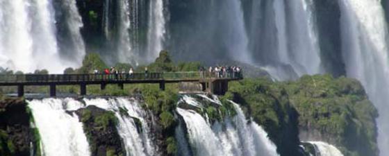
What makes the falls special for ordinary tourists is their easy access. There are walkways extending out along many of the falls on both the Argentine and Brazilian sides, allowing visitors a close and intense experience with spell binding views of these ‘great waters’.
Formation of the falls
 The formation of the falls through erosion at the base is explained on a blackboard in the visitor centre on the Argentinean side. Photo: Halfdan Carstens
 From the elevated walkway views of the U-shaped ‘Garganta do Diablo’, or Devils Throat, the largest single falls along the giant cataract come into view. Photo: Tom SmithTo understand how these falls formed, we have to go back more than 130 million years ago (Ma) to the Early Cretaceous. At that time, the earth’s landmass consisted of one very large continent called Pangaea. This supercontinent started to break apart from forces created by internal currents in the mantle. This rifting phase would eventually create the continents we see today.
Among the new continents, South America and Africa started to separate in the Late Jurassic (for details about this process see GEO ExPro, vol. 5, no 4, pp 62-66). At first, minor uplift and thinning of the continental crust ensued as extensional forces started to tear apart this huge landmass. At the same time, massive outpouring of lava flows erupted from volcanoes and fissures that formed along the rifting zones. These flood basalts filled the early phases of subsidence along the southern-most part of the South American Plate, particularly onshore in the Parana Basin where the falls are found today.
This rifting event also created the huge potential for oil development on both sides of the Atlantic margins including the supergiant fields recently discovered in the ultra-deep water provinces along the Brazilian Atlantic margin (see GEO ExPro v. 5, no. 5 pp. 22-28).
The Parana Continental Flood Basalt Province (known as the Serra Geral Formation in Brazil) is one the world’s largest covering an area over 1,200,000 km² in southern Brazil, northern Argentina, Paraguay, and Uruguay. The lavas were extruded during the Early Cretaceous period between 138 and 127 Ma and reach a maximum thickness of 1.7 km.
“The flood basalts form very hard, flat lying and erosional resistant layers that the major rivers of the region meandered across over time,” says Professor Dr. Breno Leitão Waichel of the State University of the West of the Paraná. “In fact, of all the major South American rivers, the Paraná has the most perfect adjustment to the area’s structure and it developed after the outpouring of the Serra Geral basalts. In the Iguaçu Falls area the volcanic pile is about 1,000 m thick.”
“In general, the basalts are pahoehoe flows (with the smoother, ropy style surfaces) approximately 30 m thick. Each flow has an internal 3-part division with a base, core, and vesiculated top.”
“The alignments (or fractures) related to the river paths took shape during the cooling of the lithosphere after the lava extrusions. This faulting is probably part of the basement structure that formed around the time the magmatism of the Serra Geral occurred.”
“A major fault along the Paraná riverbed (north-south structure) became evident and was identified as a stunning uplift around 80 Ma. The Iguaçu River is found along an east-west alignment with much of the present morphology being the result of water sculpturing during the Tertiary and Quaternary,” says Dr. Breno Leitão Waichel.
As the flat lying basalt flows (at least 11 individual flows in this region) were gradually uplifted by faulting, erosion started to create the falls we see today. The energy of the water falling over the abrupt faulted step creates a depression at its base. Over time, the higher energy zone at the base of the step gradually erodes back into the lower layers. Without support, the upper layers crumble progressively upstream. Large blocks of the upper lava layers can be seen at the base of the falls. The edge of the basalt cap recedes only 3 mm per year. This erosional process continues today 23 km from the original starting position at the confluence with the Paraná River.
Visiting the falls
 Water everywhere. Photo: Halfdan CarstensPlan at least two days to truly see the falls and environments around them. The area is open year-around, the photos shown in this article were taken in early May. The high season is in January and February when most Brazilians and Argentineans are on holidays. May through July are the rainy months, when the volume of water going over the falls is at its maximum. Viewing and hiking the falls trails from both the Argentina and Brazil sides is a must. Boat, rafting, and rainforest tours will top off your trip.
The town of Puerto Iguazú on the Argentina side of the park is a good place to stay with frequent scheduled bus service to the park. A short walk away from the center is Tres Fronteras offering the unusual view of two other countries, Brazil and Paraguay, at the confluence of the Iguaçu and Paraná Rivers. Each country displays their own obelisk painted with the colors of their country flag.
Local buses can take you south on a day trip to the Minas de Wanda where tours of the mines are conducted for the public, along with a museum and shop displaying the gorgeous geodes and minerals.


