The Smell of Crude Oil
Very few places on Earth combine stupendous scenery, recreation, and oil production. But in the central Colorado Plateau of southeast Utah, the San Juan River has carved two deep canyons that provide river runners with an unparalleled, three dimensional view of the Paradox Formation.
The American Southwest holds a wealth of geologic wonders, boasting more national parks and monuments than any other single region on the North American continent.
The signature landscape element in this land of strata is the deep, sinuous canyons, carved by large rivers that originate in the Rocky Mountains and flow across the arid Colorado Plateau. It might seem odd for a single place to have large rivers and an arid climate but this fortuitous combination is what makes the province so visually spectacular.
The San Juan River in southeast Utah and the two deep canyons it has carved is an excellent place to learn about the geology of this magical land.
Both source and reservoir The San Juan begins beneath the Continental Divide in southwest Colorado, at an elevation of about 4,300 meters (14,000 feet), where spectacular eruptive rocks of the Paleogene San Juan volcanic field are exposed. Prodigious amounts of snowfall melt and coalesce to form the San Juan, which then flows from its alpine setting in the Rockies to the sculpted colorful terrain of the Colorado Plateau. The rivers’ total length is about 650 kilometers (400 miles) but the San Juan’s spectacular canyons are found only in the lower 240 kilometers (150 miles). This is where the Upper Carboniferous (Pennsylvanian) Paradox Formation is exposed.
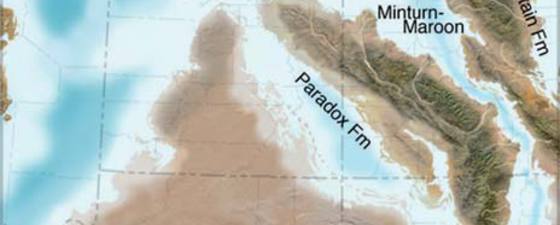
What is the Paradox Formation? It is a heterogeneous mix of cyclic and petroliferous shallow marine limestone and evaporites. The rocks were laid down along the fluctuating shoreline of the Paradox Sea, which ebbed and flowed in response to glacial cycles on the supercontinent of Gondwana (see paleogeographic map). This sea was productive for the growth of plankton and algae, and this is where bioherms (submarine algal mounds or reefs) grew parallel to the shoreline of the sea. These bioherms are one of the more interesting features found in the Paradox Formation. Many geologists have floated down the San Juan canyons to see these features in outcrop, which in the subsurface serve both as source and reservoir rocks. The ancient productivity in the Paradox Sea is what gave rise to the Aneth oil field, located along the San Juan River east of the two canyons.
The Aneth Field
 A river raft floats lazily beneath cliffs of the Upper Carboniferous Pennsylvanian Paradox Formation in one of two canyons carved by the San Juan River in southeast Utah. These same rocks are more that 1500 meters in the subsurface just 50 kilometers east and hold about 78 million barrels of proven reserves in the Aneth oil field. Photo: Wayne RanneyThe Aneth Field was discovered in 1956 and was subsequently developed by several large integrated oil companies. The field covers approximately 200 km2(50,000 acres) and is the largest oil field in the Paradox Basin. Resolute Energy Partners bought the majority of the working interests in 2007 and own and operate three of four federal production units, with estimated net proved reserves of about 78 million barrels. The oil is light, sweet crude and the company’s assets include about 260 active and 220 water and carbon dioxide injected wells on land owned on the south side of the river by the Navajo Nation. The field is considered mature and long-lived, based on its long history of production, a shallow annual decline rate of approximately 6%, and a high reserves to production ratio.
Much of this production occurs in the Paradox Formation at a depth of approximately 1,500 meters (5,000 feet). In this area, colorful Jurassic rocks cover the landscape. However, as the San Juan River flows west from the oil field it encounters a spectacular structural barrier known as Comb Ridge, one of the famous Colorado Plateau monoclines. These features are where strata was compressed and raised in impressive folds during the Laramide Orogeny, about 70 to 40 million years ago. Within a lateral distance of only about 5 kilometers (3 miles), the Paradox Formation dramatically comes to the surface within the first of the two canyons. As the river meanders and slices open the landscape, geologists get a three dimensional view of the classic reservoir body.
Oil seeping into the river
 The Aneth oil field is bisected by the San Juan River upstream (east) of its two canyons. It was first developed in 1956 by Texaco and Mobil oil companies (a Mobil derrick is shown here in a 1993 photo) but holdings were recently acquired by Resolute Energy Partners. Much of the field lies on the Navajo Indian Reservation, the largest Native American reservation in the United States.Although Comb Ridge is technically a monocline pioneer oilmen called this geologic structure the Raplee anticline, since the strata farther west dive once again into the subsurface. It is in this area that oil in the Paradox Formation was first discovered in the 1890’s, since it was visibly leaking from the rocks and could be smelled along the river banks. It is here that oil was trapped in an unusual synclinal oil field – the Mexican Hat syncline. This small field began to produce at the turn of the 20th century and although there was much celebration about its discovery, the remoteness of the area caused all of the oil to be consumed locally. Even today small pump jacks can be seen extracting the black liquid from the red rocks near the town of Mexican Hat, named for an unusual balanced rock along the banks of the river.
The second of the San Juan’s two canyons begins just below Mexican Hat as the rocks rise once again from the subsurface along inclined strata. Here the river meanders in huge, graceful loops even though it is entrenched more than 600 meters (2,000 feet) into the ground. These are the world famous Goosenecks of the San Juan, where the river meanders at a ratio of three to one – the river flows 23 kilometers in its channel but moves only 8 kilometers to the west (14 by 5 miles). One wonders how a river so deeply entrenched could meander so wildly, since meanders are usually indicators of very mature river systems, while steep canyons are evidence of immature systems. Obviously, this part of the Colorado Plateau has experienced an unusual history.
Geology, oil and scenery
 Wayne Ranney is a geologist by education and works as a geology interpreter and tour guide for organizations such as the Smithsonian, the Museum of Northern Arizona, and the Grand Canyon Field Institute. Ranney is the author of several books about the geology of the southwest. Photo: Halfdan Carstens
 Uplifted strata along the Comb Ridge monocline with the San Juan River in the center. The river flows away from the viewer but then turns abruptly right (west) in the heart of the Raplee anticline where the Paradox Formation becomes exposed in the first San Juan canyon. Photo: Wayne RanneyThe meanders are thought to have originated in the Oligocene or Miocene before the San Juan and Colorado Rivers were hydrologically connected to the Gulf of California. This connection, which is documented to have occurred about 6 million years ago, is most likely what caused the deepening of the canyons by knickpoint migration and headward erosion. The meanders were emplaced before this episode of deep dissection when the river may have been trapped in a closed depression. The deep dissection of the canyons has removed much of the evidence for the rivers’ earlier history and that is why the story of the Goosenecks and the San Juan is still unresolved.
Whatever the specifics, the San Juan River is a treasure of geology, oil, and scenery. A trip down the San Juan is an unforgettable experience that reveals evidence for ancient algal reefs, spectacular folded strata, and the smell of crude oil as it leaks from the ground.


