Broadband seismic data unlocks new play potential. The recent world-class Baleine discovery within the Deep Tano Basin has attracted renewed exploration interest for the offshore Côte d’Ivoire. Its structural complexity and depositional stratigraphy, resulting from multiphase rifting of this basin, require high-quality seismic data to develop detailed geological models.To achieve this, CGG recently conducted a seismic stratigraphic analysis using the CDI-14 broadband multi-client 3D seismic dataset over the Grand Bassam subbasin. The goal was to develop new insights into Late Cretaceous depositional mechanisms and key facies distribution to shed light on the potential prospectivity of this basin. A recent seismic stratigraphic analysis demonstrates the presence of key petroleum system elements and the potential to develop new, high-impact prospects. Over the last few years, the industry’s focus on hydrocarbon exploration has dramatically declined. Transforming resources into reserves has become a challenge for most African regions that have seen their production profiles shrinking substantially (Martin, 2022). Despite this decline in exploration, there has been a high number of recent world-class discoveries in Africa. Among them, Baleine (Eni, 2021), offshore Côte d’Ivoire, is recognised as one of the biggest discoveries in recent history. A facies distribution model has been derived from seismic stratigraphic analysis, using CGG’s multi-client 3D broadband seismic data from its Earth Data Library over the Grand Bassam subbasin, to help predict high-potential leads for further exploration. Over the last two decades, CGG has gained extensive insight into the acquisition, processing and interpretation of data sets in Côte d’Ivoire. Our first survey in 1999, comprising approximately 814 km2 of 3D seismic data, was acquired to provide an understanding of basin structure and prospectivity and enable the mapping of clastic and carbonate systems within the Tano Basin. In 2014, driven by in-house geological models and prospectivity predictions, CGG acquired a further 4,400 km2 of 3D broadband seismic data (CDI-14) in the deep-water offshore area of Côte d’Ivoire. The aim was to enhance imaging of Late Cretaceous plays that remained highly speculative and poorly understood at the time. Since the survey was acquired, the Pelican and Rossignol wells, drilled by Anadarko in 2016, confirmed CGG’s predictive models, and Eni’s Baleine discovery in 2021 put the Ivorian offshore basins at the forefront of exploration in West Africa. With a total number of 137 exploration wells drilled since 1954 and 22 discoveries since 1974, the Côte d’Ivoire offshore territory has attained the status of a proven hydrocarbon province. Two main exploration phases have identified two major working petroleum systems (Martin et al., 2018): From a geodynamic standpoint, the deep Ivorian basin has traditionally been described as a classic and well-known example of a divergent basin. The basin is bounded by transform faults that segment the African Equatorial margin into several transform margins (Mascle et al., 1995, Basile, 2015). Throughout its development, the basin has undergone multiphase rifting, tectonic reactivation, and volcanism, which have strong implications for sediment distribution and petroleum system development. CGG’s recent seismic stratigraphic analysis has provided new insights into the Late Cretaceous depositional mechanisms and facies distribution, through the identification and analysis of three main depositional sequences (seismic foldout). Overlies the Late Albian unconformity and is observed across the survey as a continuous, sub-horizontal and aggradational interval that displays a post-kinematic accommodation to the paleo-relief. Stacking patterns observed within this sequence suggest deposition occurred during a marine transgressive cycle sag phase, related to thermal relaxation after the continental breakup. The top of this sequence has been interpreted as a maximum flooding surface during maximum marine transgression. This sequence is believed to host the prolific regional and class II Cenomanian oil-prone type II source rock, deposited in a depocenter identified within the north-eastern area of the survey (Figure 2). Considering its proximity to the recent Baleine discovery, the source rock within this area could have the potential to generate significant commercial quantities of oil. This unit, developed between sequence A and overlain by the Senonian erosive unconformity (seismic foldout), displays a distinctive progradational pattern in connection with a relative fall in sea level. The onset of this sequence is likely to have occurred during a high stand system tract (HST) cycle and an early falling stage system tract (FSST) cycle. An extensive mass transport complex (MTC), in the form of a debris flow, has been observed towards the bottom of the sequence and mapped along the eastern half of the survey. This suggests slope instability and limited sediment transport between the extensional and compressional domains (Figure 3a). The upper section of the sequence is characterised by a system of NE-SW moderately sinusoidal turbiditic channels and basin floor fans (Figure 3b). These were likely deposited during the FSST and early low stand system tract (LST) cycles. Onlap terminations towards the top of the sequence indicate retrogradation during the last stages of the LST, in connection with the relative onset of rising sea levels. Overbank deposits associated with the observed turbidite channels are characterised by sediment waves from overspills and flow stripping. This sequence is observed on the seismic as three major, vertically stacked turbiditic complexes displaying a retrogradational depositional relationship (Figure 4). The sequence hosts a system of lenticular unconfined slope fans, deposited during the LST and the onset of the transgressive system tract (TST) cycles. The internal architecture and geometries of the terminal feeder sections and inner distributary channels are related to the depositional dynamics of deep marine turbidite deposition. The turbidite channels described in Sequences B and C form potentially highly prospective reservoirs. Our seismic stratigraphic and attribute analysis indicates that within most channels there is a series of recurring features which provide an understanding of the observed reservoir facies and heterogeneities. An understanding of the sinuosity of channels in Sequence B and the stacked nature of turbiditic channels observed in Sequence C, along with an understanding of facies distribution, sheds great light on the reservoir distribution and potential in the deep waters of the Tano Basin. The seismic stratigraphic analysis presented here has been fundamental in understanding the prospective potential of the deep-water region of Côte d’Ivoire. This has been achieved through the observation and interpretation of Late Cretaceous depositional features and mechanisms described within Sequences A, B and C. Based on the interpretation, distribution of hydrocarbon fields, and data from nearby wells, we determine that the maximum vertical thickness of the Cenomanian class II source rock occurs primarily within the northeastern area of the CDI-14 survey. Reservoir facies and distribution have been inferred from analysis of the stacking patterns observed in Sequences B and C, in which a prolific system of NE-SW turbiditic channels and fan-like architectures have been identified. Channels in Sequence B show “feeder-type” morphologies typical of upper to middle continental slope environments. By contrast, Sequence C exhibits geometries and orientations typical of lower slope to basin floor fans. Fault interconnectivity between source rock and reservoir facies is likely to be related to crustal readjustments, as evidenced by volcanic structures and faults identified throughout the area. The seismic stratigraphic analysis and conclusions discussed herein demonstrate the presence of key petroleum system elements and the potential to develop new, high-impact prospects. All images courtesy of CGG Earth Data. The author would like to thank Direction Générale des Hydrocarbures (DGH) Côte D’Ivoire and PetroCI for their great collaboration and for allowing us to publish this paper as well as my CGG colleagues for their support and reviews during this study. Basile, C. (2015). Transform continental margins – part 1 concepts and models. Martin, J. (2015). What lies beneath the Deepwater Tano Basin?. Vol. 12, No. 5- GEOExPro Martin, J. (2022). Africa’s Exploration landscape: Past, present and future. African Energy Summit Mascle, J., Lohmann, G., Clift, P. (1995). The Côte d’Ivoire -Ghana transform margin eastern Equatorial Atlantic. Joides Journal, 21 (3), 4-10 Morrison, J., Tea, J., N’Zalasse, B., Boblai, V. (1999). A sequence stratigraphic approach to exploration and re-development in the Abidjan margin, Côte d’Ivoire. Offshore West Africa ’99 Conference and Exhibition. Scarselli, N., Duval, G., Martin, J., McClay, K., Toothill, S. (2018). Insights into the early evolution of the Cote d’Ivoire margin (West Africa). Passive margins: Tectonic, Sedimentation and Magmatism. Vol. 476 Geological Society of London, 2018. pp1-25
Baleine discovery: Côte D’Ivoire’s exploration “Black Swan”
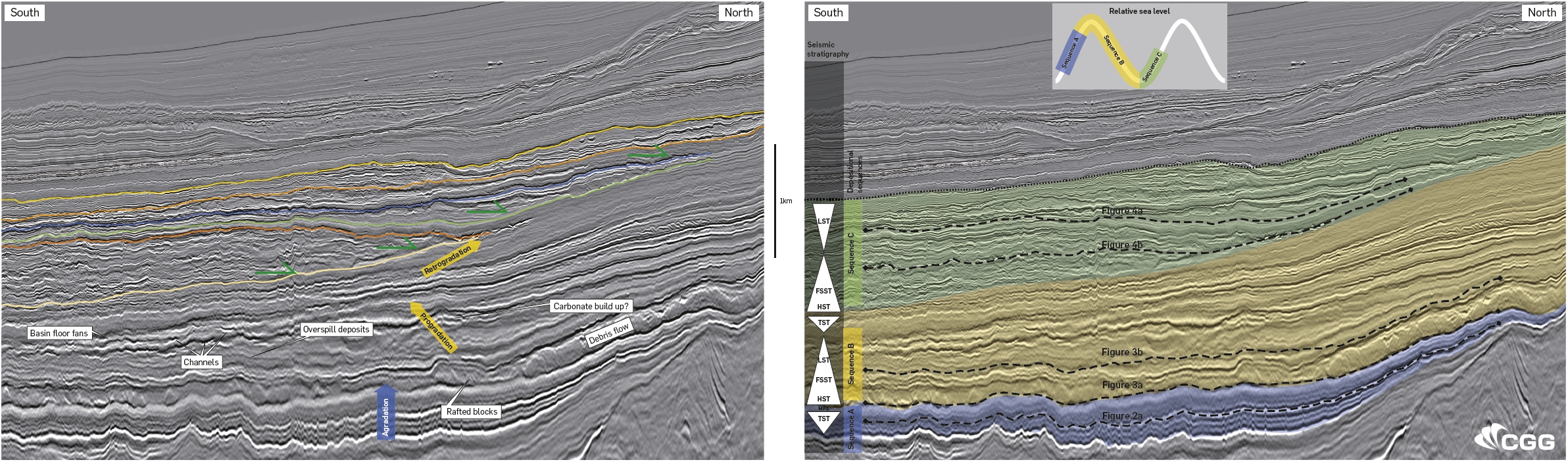 Recent stratigraphic analysis of 3D seismic broadband data is shown in this section running from south to north through the Grand Bassam subbasin. The left-hand panel shows interpreted stratigraphic horizons, seismic reflection terminations and key features. The right panel shows the depositional sequences and the horizons analysed with spectral decomposition in the figures on the following pages. Courtesy of CGG Earth Data.
The Tano Basin – revealing late cretaceous depositional styles in a frontier basin

Côte D’Ivoire – CGG data coverage

Multiple proven hydrocarbon plays

Seismic stratigraphy and depositional patterns

Sequence A
Sequence B
Sequence C
Implications for petroleum systems
Acknowledgements
References
Related Articles


