A promising exploration method
Researchers at the University of Bergen have shown that geophysical measurements of self-potential can detect sulphide deposits in the deep sea.
Half way between Norway and Greenland we find a small stretch (five percent) of the world’s longest mountain range (65,000 km). The mid-oceanic ridge forms the basis for geologists’ understanding of the earth’s evolution – continental drift, seafloor spreading and plate tectonics.
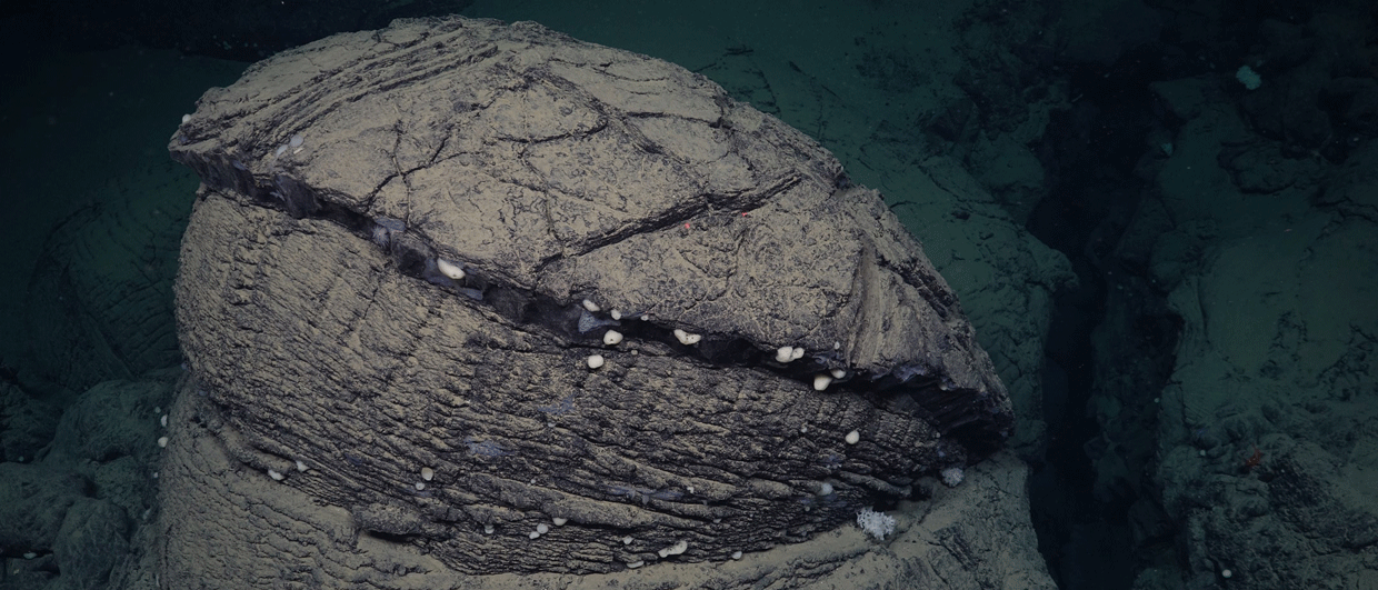
It has also long been known that the subsea volcanic mountain range contains minerals and metals. Two types of deposits have been discovered in Norwegian waters: solid sulphides and manganese crusts.
Norway has initiated an opening process that may lead to areas in the Norwegian Sea being announced in 2023 or 2024. The Norwegian Petroleum Directorate (NPD) is currently conducting a resource evaluation of Norwegian marine mineral resources, and concurrently, commercial exploration companies are preparing by acquiring knowledge and developing technology and exploration methods.
It can thus be useful for them to learn from those that have years of experience working in the deep-sea realm.
“There are several methods for detecting sulphides. We have seen, through several cruises, that self-potential is a geophysical measurement method that works well,” said Solveig Lie Onstad, PhD candidate at the Department of Geosciences and the Centre for Deep Sea Research at the University of Bergen (UiB).
The occasion was a seminar hosted by NPD on the second of June in connection with the release of the dataset that may be the most comprehensive found globally on deep-sea minerals.
Self-potential (SP) is a measure of electrical voltage differences in rocks. Such stress differences can occur, for example, in rocks that contain conductive minerals and metals, including sulphides. This type of measurement can be performed in the deep sea using self-propelled and remote-controlled underwater robots (AUVs) equipped with sensors.
The deep-sea researchers at UiB have, together with and in addition to the NPD, carried out a number of cruises along the spreading ridges in Norwegian waters, and can take credit for the discovery of several of the sulphide deposits found so far.
The deposits are formed by hydrothermal vents that occur along the spreading zones. The vents carry mineral-rich, boiling hot water up to the seabed, and the sudden encounter with the cold seawater causes the minerals to precipitate. Sulphide deposits occur at both active and fossil (inactive) hydrothermal sources.

Detected anomaly
For extraction purposes, it is the passive deposits that are of interest as they host much less biological diversity. They can be more difficult to find than the active ones though, as they do not generate a warm, mineral-rich and detectable plume in the water column.
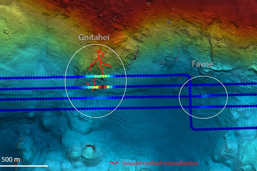
“Gnitahei is a sulphide deposit that was discovered solely because we saw an anomaly in the SP data,” Onstad said.
Gnitahei is located on the Mohn’s Ridge between Jan Mayen and Bear Island. Close to Gnitahei is Fåvne, which is another sulphide deposit. Gnitahei and Fåvne are two different deposits. The main difference is that Gnitahei is inactive, while Fåvne is an active hydrothermal sulphide deposit.
According to Onstad, the researchers were able to identify Fåvne by several measurement methods. “We registered a temperature signal, we saw turbidity in the water, as well as a small SP signal.”
Measurements of the SP strength in a given area can thus work well for explorers that are searching for extinct sulphide deposits. But SP measurements also provide another parameter of interest.
“In addition to the strength of the SP signal, we can also measure the direction. We have seen that the data simply are “pointing us” to the sulphide deposits.”

A method worth using
Exploration companies should take note of the experiences that UiB researchers have had with the use of AUVs and measurements of self-potential as an exploration method. However, the method is not without challenges.
Along the spreading zones in the deep sea, the terrain can be rough with deep valleys and high peaks. This is a challenge for the AUVs, which should fly at a certain height above the seabed, while of course avoiding colliding with the terrain.
“Optimal flight altitude during data collection is 40 – 70 meters, and the terrain is thus a challenge. The fact that they have to operate relatively close to the seabed also means that they cannot cover large areas per unit of time, which in turn means that they have to fly in lines over a terrain with high line density (many parallel lines),” Onstad explained.
The research fellow also pointed out noise in the data caused by vertical movements in the water column as a possible challenge, and that the method only measures electric current, and thus does not say anything else about the physical properties of the rocks.
“But the benefits outweigh a lot of the drawbacks. We have shown that SP measurements detect sulphide deposits, and that a strong and clear anomaly means a high probability of a nearby deposit. Even weaker anomalies show a clear trend towards the source. Self-potential is a method worth using,” concluded Solveig Lie Onstad.
RONNY SETSÅ