Fast Delivery of GeoStreamer X Multi-Azimuth Data
GeoStreamer X represents a faster and more efficient method to improve illumination of complex targets.
The success of the GeoStreamer X Viking Graben survey demonstrates the robustness of the GeoStreamer X concept in operation. All key targets were efficiently covered by two additional azimuths using an innovative configuration combining multisensor broadband fidelity with wide-towed source efficiency, a tailored long-offset solution for velocity model building, and multi-azimuth (MAZ) illumination. An early-out PSDM Multi Azimuth (MAZ) stack was delivered in only 16 weeks, a comparable time scale to conventional single azimuth processing, proving from acquisition through to imaging, GeoStreamer X is a significantly faster method of achieving advanced offset- and azimuth-rich data than node-based exploration.
The GeoStreamer X Viking Graben project is a multi-azimuth long-offset survey combining three acquisition directions with a wide-tow source configuration for advanced offset- and azimuth-rich data. The Ramform Vanguard towed 12 streamers, including two 10 km long tails to provide offsets for FWI, and a wide-tow multi source with 250 m total separation. Close to zero offset was achieved and is used for optimal near offset sampling and shallow imaging. The setup also provides dense spatial sampling for high-resolution imaging offering improved illumination with a significant efficiency gain and reduced environmental footprint.
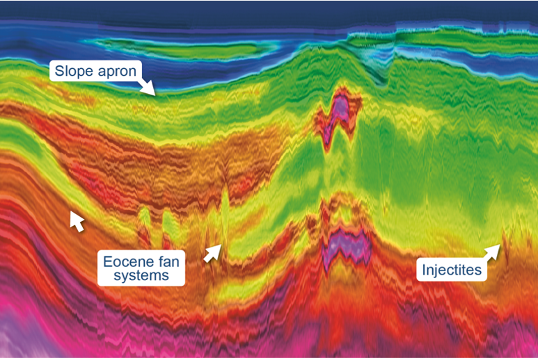
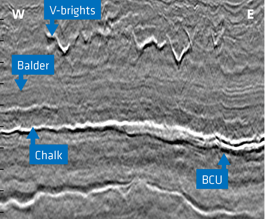
The main imaging challenges in the area are the illumination below shallow channels, and resolving a complex sandy interval in the Hordaland Group. This includes cemented sand injectites that introduce anomalously high velocities (called v-brights), and below this, a thin chalk layer which absorbs energy and generates multiples.
Resolving the Shallow to Reveal the Deep
The shallow time slices illustrate the improved illumination and resolution provided by merging the 2011 survey with the 2019 acquisition. The early-out MAZ volume highlights the benefits of the multi-azimuth solution in this mature area, with enhanced signal-to-noise ratio, improved structural definition, and improved clarity of subtle amplitude details.
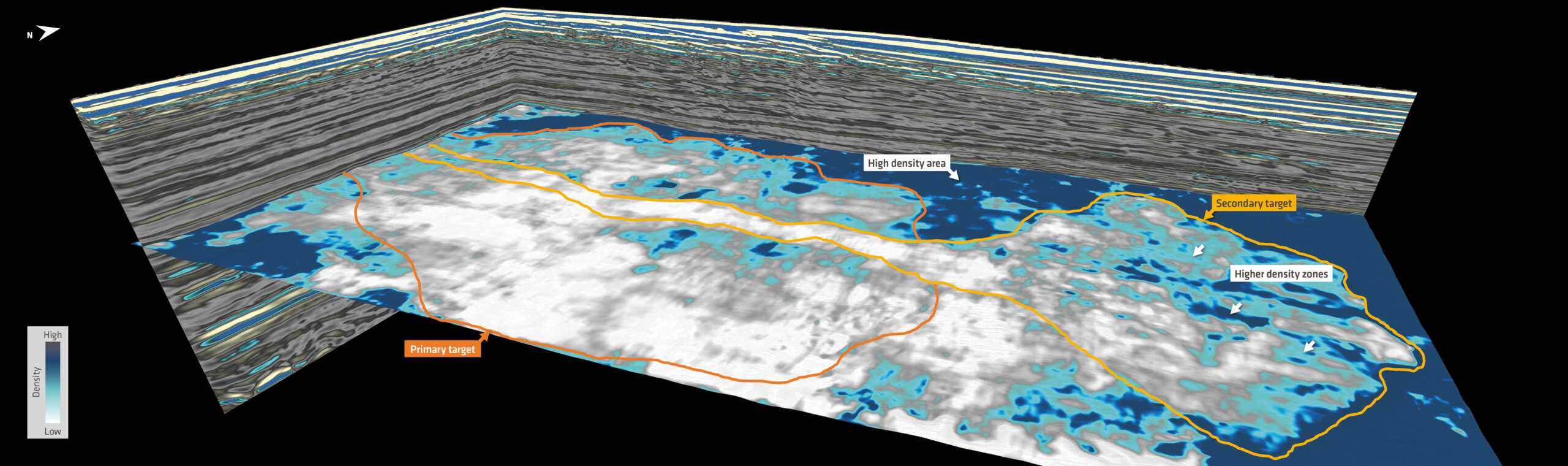
The MAZ time slice uncovers a number of large channels within the first 50 ms–350 ms below the seabed. Imaging of these channels has been an issue on legacy data due to the lack of near-offset data. The original survey configuration shows clear acquisition footprint which can have a detrimental effect on AVO analysis. While the sail-line related amplitude footprint may be mitigated in processing, the lack of detail in the image has serious consequences for shallow amplitude analysis, be it for drilling hazard identification or shallow prospectivity analysis (for example in the Barents Sea). Properly resolving these channels provides a clear improvement in the seismic section underneath.
The wide-tow source solution considerably increases the amount of near-offset data which is recorded in a single sail-line direction, as shown by Widmaier et al. (First Break, November 2019). The GeoStreamer X Viking Graben survey demonstrates full coverage of reliable offsets in the 50–125 m range and provides reliable interpretation attributes and added benefits in processing steps such as demultiple, together with other techniques which exploit information from multiples (such as separated wavefield imaging).

Full Integrity Processing to Enhance Target Resolution
As new oil and gas reserves are becoming harder to find, the exploration community has increased their focus on stratigraphic and subtle structural traps where optimized illumination and high-resolution imaging at the reservoir level is required to be successful. The two seismic sections demonstrate a zoom in to the Paleocene and Jurassic section (chalk = strong white peak, middle of the images) which highlights considerably improved interpretability of the early-out MAZ volume compared to the single azimuth image. Key improvements include better continuity of the Paleocene reflections, especially underneath the v-brights, as well as greater event continuity and improved signal-to-noise ratio in the Jurassic section. This significantly increases the confidence of the interpretation and potentially seismic reservoir characterization.
The objective of this novel solution is to exploit the rich offset and azimuth information in all aspects of the imaging sequence, which includes 3D pre-stack demultiple, full azimuth data regularization, and MAZ velocity model building. The velocity model used for the fast imaging was based on the 2011 survey using6 km data. The complete full integrity MAZ products will maximize resolution and ensure usability of any signals present to the interpreter in any acquisition direction. As the uplifts based on combining several datasets are already significant, we have much to look forward to when incorporating the long offsets (10 km) for multi-azimuth Full Waveform Inversion (FWI), multi-azimuth high-resolution reflection tomography and the final anisotropic PSDM.

Expanding GeoStreamer X Coverage on the NCS
GeoStreamer X has great potential on the NCS, delivering a robust and efficient solution to provide the data quality step-change needed to discover new resources and add value for clients. We have ambitions to expand the concept during the 2020 season and are currently reviewing opportunities in the Viking Graben.
TEXT: JULIEN OUKILI and KAI FLØISTAD, PGS