Re-imagining the proven hydrocarbon basins offshore Nova Scotia
In 1958 Parke Dickey wrote, “We usually find oil in new places with old ideas. Sometimes, also, we find oil in an old place with a new idea, but we seldom find much oil in an old place with an old idea.” However, in 1958, modern seismic imaging was not even science fiction yet. Now, with modern processing techniques, you can re-image the subsurface (or image it for the first time more likely) by reprocessing the legacy data from almost any ‘old place’ and oil and gas will fall out of the data at you.
Geological thinking hasn’t progressed much since the concepts of sequence stratigraphy were developed in the 1980s, so new exploration ideas now come largely from new or reprocessed seismic data. In this century perhaps the greatest collective advance in our industry’s science, arguably to the greatest scientific benefit for all mankind, has been in the field of seismic processing. Tools such as SRME (Surface Related Multiple Elimination), shallow water de-multiple and de-ghosting (removing source and receiver notches/ghosts) which are now standard, have revolutionised imaging of sedimentology, structure, DHIs (Direct Hydrocarbon Indicators) and source rocks over the last 20 years. Reprocessing legacy data can now unleash idea-tsunamis in old basins. And in some basins, where the original seismic just wasn’t up to the job, old ideas in an old place – will work just fine. Offshore Nova Scotia is one such basin.
The proven shelf of Nova Scotia
On the shallow water shelf (mostly below 100m water depth), proven Jurassic source rocks charge proven Jurassic and Cretaceous reservoirs. A number of gas discoveries made around Sable Island in the late 1990s and early 2000s were developed and produced. Now these fields are depleted and most of the infrastructure decommissioned. Prior to development, 3D data was acquired over these discoveries allowing some infill exploration success. Yet, these 3D surveys have never been reprocessed. Recent analyses by CNSOPB (Canada Nova Scotia Offshore Petroleum Board) (Smith et al., 2014, 2018) have shown that even on these ancient datasets, ca. 1.3 Tcf of discovered but not developed potential reserves remain. When the reprocessing of the Sable Island 3Ds is complete, they will not only reduce imaging uncertainty on the existing unproduced discoveries, but also reveal additional targets and new plays to chase, allowing for a rejuvenation of exploration, reutilisation of some of the infrastructure and the renewal of production of advantaged hydrocarbons on this shelf.

Ultimately, when all the possible commercial reserves have been discovered and developed in any basin it becomes over-mature so that depleted fields will be decommissioned and abandoned. Yet how do we know when this point has been reached? The exploration of almost every basin tells us that when a basin looks to be exhausted, it is only the explorers who are exhausted – and with new data and new imaging of the subsurface, then new plays and missed traps in old plays are found so a new creaming curve of exploration value creation erupts. New plays for new times on the shelf also include the only potential for developing Carbon Capturen Utilisation and Storage (CCUS) in Eastern Canada.
The slope and Bbsin floor salt play
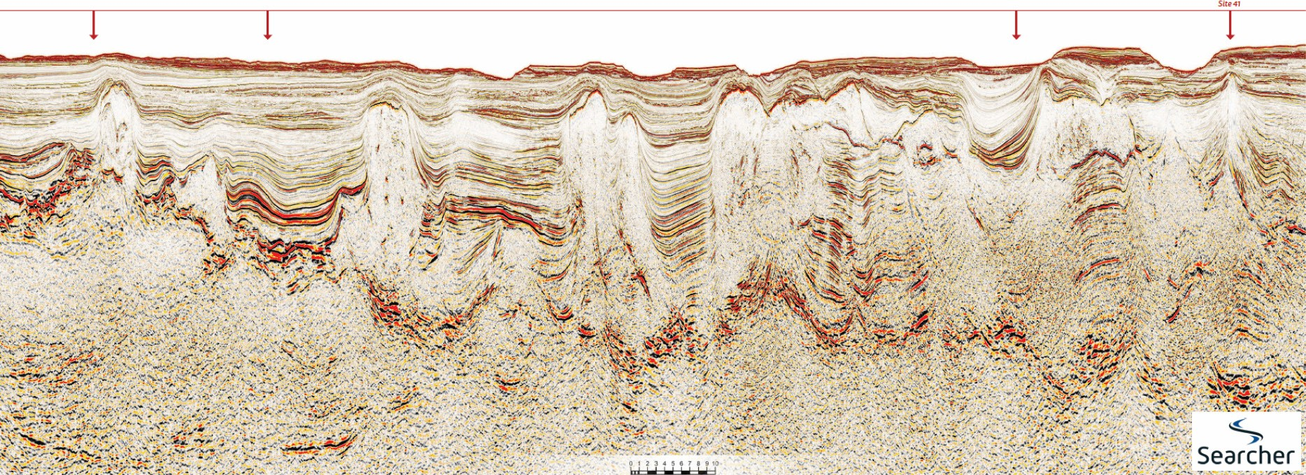
Off the shelf into the slope and basin floor domain – a whole different adventure awaits the explorer. Slope channels can be mapped bringing coarse clastics off the Scotian slope into a glorious salt basin. To the south and west this salt basin is categorised by salt diapirs and walls that separate sediment pods of Jurassic to Cretaceous age. Above the migration-focusing diapirs, shallow fluid escape features link to both repeat satellite slick clusters, and oil recovered from seabed cores (see Foldout line) (Fowler and Hubert, 2020). To the north and east, salt lavas extruded on the seabed at the end of the Cretaceous have formed a salt canopy, in places wrapping the underlying pods up like Beef Wellington, generating potentially perfect top and side seals to thick grounded Jurassic to Late Cretaceous sediment pods. Over such simple geology with complex imaging challenges, one of the world’s most exciting Wide Azimuth (WAZ) seismic surveys has been acquired (Tangier 3D, Foldout line and Figure 3) that has allowed for astonishing imaging beneath the canopy.

The recently drilled Aspy-1 well proved a working hydrocarbon system, finding good oil shows in silts that were in closure under a salt canopy (Nova Scotia, Aspy D-11, Subsurface Well History Report for CNSOPB). This is the play opening observation that will ignite exploration on the slope and basin floor of this margin. The next stage of exploration can focus on the pursuit of the coarse clastic sand systems that poured off the shelf into the salt topology. These sands systems can be mapped and conflated with seismic characterisation of source rocks in this basin.

Advantaged hydrocarbons: Nova Scotia is the new Downton Abbey
The first European settlers in Nova Scotia in the 17th century were French Acadians who were forced to leave the area after 1755 by the British (in ‘Le Grand Derangement’) and migrated south to found the ‘Cajun’ communities in the southern United States. From bleak times to future fortune – so stands the neglected shelf of Nova Scotia today. A shelf blessed with hydrocarbon reserves discovered and developed in the 20th century looked privileged enough but has been neglected for 20 years. We now have the technology to re-image the geology near to the discoveries (a version of in-field exploration), re-evaluate the discoveries in hand, resolve the plays that could not be imaged before and image entirely new plays. On a grander scale the slope and deepwater salt basin are poised for success with a newly proven hydrocarbon system and some of the most amazing seismic ever acquired on planet Earth with which to chase reservoirs, source rocks and traps.
Nova Scotia has encouraging new commercial terms that have just got better through supportive regulator and government legislation that provides a clear path to acreage access and operational stability. Nova Scotia has the pedigree of advantaged aristocracy – and is ready in the 21st century for a new technology-led future.
References
Smith, B.M., Makrides, C., Altheim, B. and Kendell, K. 2014. Resource Assessment of Undeveloped Significant Discoveries on the Scotian Shelf, CNSOPB Geoscience Open File Report.
Smith, B.M., Kendell, K., Brown, D., Makrides, C. and Altheim, B. 2018. Call for bids NS1-3 – Seismic interpretation, well summaries, source rock, and exploration leads in the Central Scotian Shelf. Sable Subbasin. CNSOPB Geoscience Openfile Report 2018-0002MF.
Fowler, M. and Hubert, C. 2020. Geochemistry and Microbiology in Seep Prospecting. GeoExPro Vol. 17, No. 2, pp.56–58.


