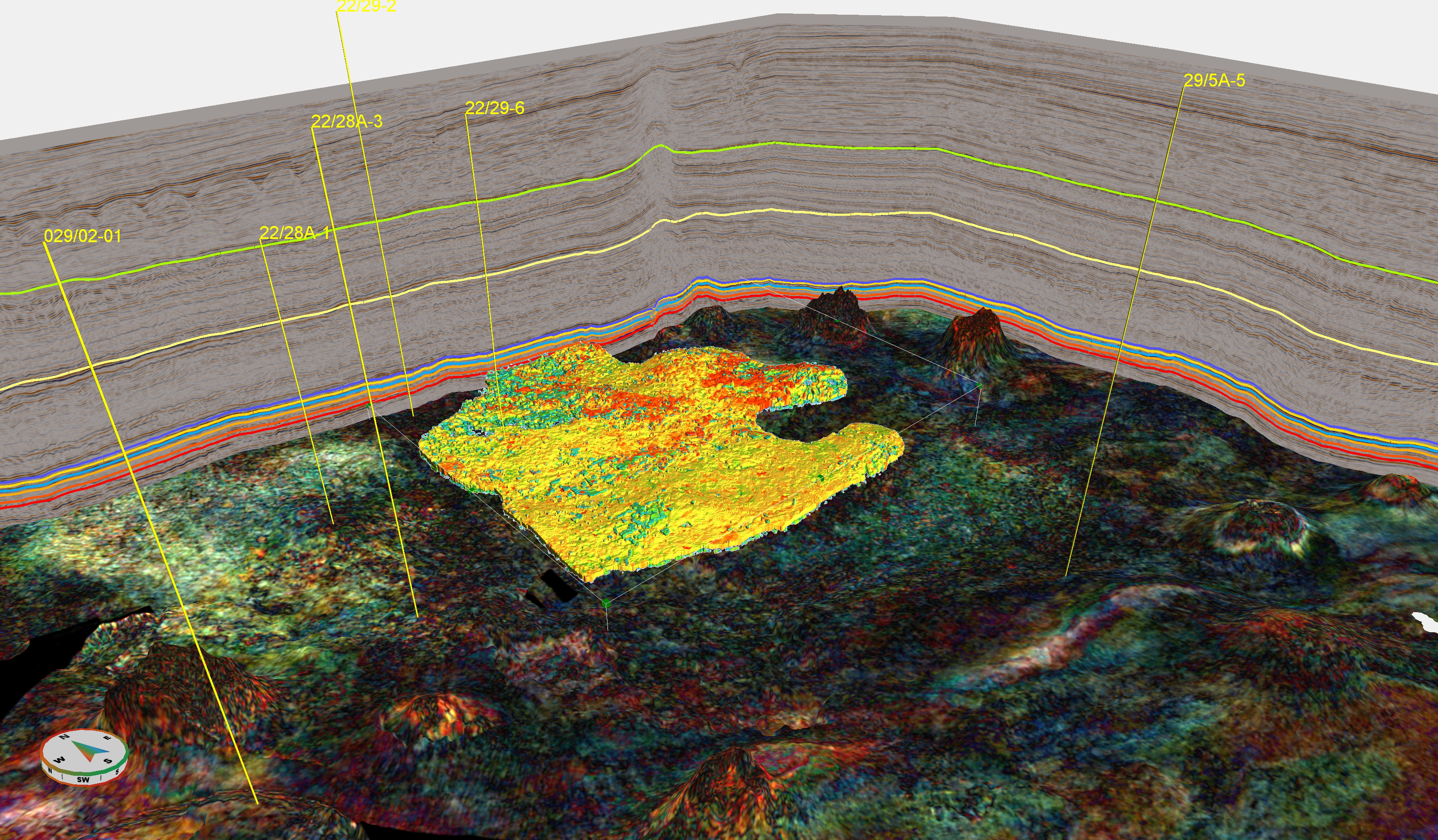
It is often said the best place to find oil is in an oil field and if that is true then perhaps the second-best place to find oil would be below an existing oil field. These principles, along with a focus on targeting complex high-pressure, high-temperature (HPHT) reservoirs to address industry needs, motivated CGG to acquire in 2020 a 1,650 km2 high-density Ocean Bottom Node (OBN) multi-client survey with Magseis Fairfield across two highly prospective areas in the UK Central North Sea (Figure 1).
Figure 1: Location map for the OBN Phase 1A and 1B surveys overlying CGG’s Cornerstone Evolution towed-streamer surveys.
The targeted Cornerstone OBN survey combined with CGG’s latest imaging technology complements CGG’s regional high quality Cornerstone Evolution towed-streamer surveys by generating subsurface images of unprecedented quality in the most challenging areas to significantly de-risk field development and near-field exploration.
Location and Brief Exploration History
Phase 1A of the OBN survey covers the Marnock field, at the heart of the Eastern Trough Area Project (ETAP), which produces gas condensate from Triassic Skagerrak Formation sandstone reservoirs. Also covered are the Mungo, Monan and Mirren fields which all produce mainly oil from Paleocene Forties Formation sandstone reservoirs within four-way dip-closures created and pierced by the diapiric movement of Permian Zechstein salt.
The fields contain steeply dipping reservoir units with widespread slumping and sliding observed (Pooler & Amory, 1999). The Murlach field, previously named Skua, which produced oil and gas between 2001-2004, and the Birgitta gas condensate discovery are currently being developed as tie-backs to ETAP with both expected to commence production by 2025. Both will produce from Skagerrak Formation reservoirs.
The smaller Phase 1B of the OBN survey is centered over the Fram field which began production in 2020. After an earlier unsuccessful attempt to appraise Fram through development using a standalone FPSO in 2012-13, it is now tied-back to the Shearwater platform. The Fram field produces gas condensate from Forties Formation sandstones within a four-way dip-closure pierced by a Zechstein salt diapir.
The survey also covers Capercaillie, discovered in 1983 and successfully appraised in 2017, with a tie-back to the Stella hub planned. This light oil and gas condensate accumulation, within a three-way dip-closure with pinch-out of the Lower Eocene Rogaland sandstone reservoir towards the southwest, is part of the same play that contains the Abigail and Vorlich fields.
ACQUISITION AND IMAGING
Both phases of the OBN survey were acquired using a 100 x 300 m node spacing and a 50 x 50 m source grid. Representing the largest OBN survey ever acquired in the North Sea, it was specifically designed to address the challenges associated with deeper Jurassic and Triassic reservoirs, typically under HPHT conditions, and the presence of complex structures associated with halokinesis.
Long-offset and full-azimuth acquisition was utilised to deliver a rich low-frequency signal (Refaat et al., 2021) with the aim of achieving enhanced noise removal and significantly improving illumination of deep targets and steeply dipping reflectors. The OBN survey is suitable for use in 4D seismic analysis.
Figure 2: Comparison of: a) towed-streamer Cornerstone Evolution, and b) OBN velocity models, demonstrating the uplift achieved from the OBN dataset and CGG’s advanced imaging, with discreet geological features identifiable in the velocity model.
Following acquisition, the OBN data was imaged using advanced demultiple, Time-Lag Full-Waveform Inversion (TLFWI, Wang et al., 2019) for improved velocity model building and high-resolution absorption (Q) imaging to provide a high-fidelity broadband and Quantitative Interpretation compliant dataset. Full-Waveform Inversion (FWI) accurately computes highly detailed, data-driven models of subsurface velocity, Q and reflectivity (Figure 2) by minimising the difference between observed and modeled seismic waveforms.
TLFWI is a proprietary CGG technology that delivers further dramatic improvements in seismic imaging by minimising classic FWI issues related to cycle-skipping from an inaccurate initial velocity model, amplitude mismatches and poor signal-to-noise ratio. It has improved the entire section of the velocity model from the complex overburden to intra-chalk and sub-chalk layers including below the BCU (Refaat et al., 2021).
PS imaging, coming from the converted waves, has been used to complement conventional PP imaging. It provides increased resolution, additional information on rock properties for more stable and reliable elastic rock-property inversion, details about fracture orientation and improved imaging through gas clouds which attenuate P-wave energy (Casasanta & Gray, 2015). A full PS processing and velocity model building sequence has been applied to the PS data.
OBN Versus Towed-Streamer
The Phase 1A and 1B datasets imaged with CGG’s proprietary TLFWI technology deliver a step-change in imaging quality even when compared to CGG’s market-leading towed-streamer Cornerstone Evolution multi-client surveys. The biggest uplift is observed below the Base Cretaceous Unconformity (BCU), on the steeply dipping flanks of Zechstein salt diapirs and beneath those same salt diapirs (Figure 3).
Within the Phase 1A survey area, the sub-BCU geology consists of a series of Triassic pods and rafts and Jurassic inter-pods that formed in response to halokinesis. The Triassic pods and rafts are predominantly composed of Lower Triassic Smith Bank mudstones overlain by prograding Middle and Upper Triassic Skagerrak sandstones and mudstones.
The monotonous mudstones of the Smith Bank Formation have historically appeared seismically transparent and were further obscured by high levels of noise (Goldsmith et al., 2003). However, CGG’s OBN imaging delivers outstanding results resolving low impedance contrasts and detailed fault patterns within the Smith Bank and Skagerrak Formations allowing regional correlation of seismic markers (Figure 3).
Several Triassic fields suffer from stratigraphic and/or structural compartmentalisation and the OBN data helps overcome these development challenges, contributing towards higher production efficiency.
Figure 3: Comparison of regional WSW-ESE seismic lines: a) Cornerstone Evolution towed streamer, and b) OBN, showing the enhanced resolution of sub-BCU reflectors and improved illumination of sub-salt structures on the OBN data. Arrows indicate key features.
Mapping Intra-Skagerrak Barriers in Murlach
The Murlach field is penetrated by three wells which encountered different parts of the Skagerrak stratigraphy. The wells show differences in the depth of the oil-water contact (OWC), strontium isotopic ratios and oil geochemistry over a distance of less than 2 km, indicating that the field is compartmentalised (McKie et al., 2010).
Murlach is a four-way dip-closure at the crest of an easterly tilting Triassic raft. The Skagerrak reservoir subcrops the BCU where it has been eroded with truncation of dipping reservoir units which become younger towards the east. Intra-Skagerrak reflectors, and their subcrop pattern on the BCU, are clearly imaged with CGG’s advanced technology and the OBN dataset (Figure 4).
Correlation of these reflectors clearly indicates that the 22/24b-7 well penetrated younger reservoir units than the 22/24b-9 well which encountered the deeper OWC. Compartmentalisation within the Murlach field is likely to be stratigraphic, rather than structural, with Skagerrak sandstones vertically separated by regionally correlatable shale packages (McKie et al., 2010). It will be crucial for development wells to be suitably placed with horizontal wells required to intersect multiple reservoir units which may not be in communication with each other.
Figure 4: WSW-ESE OBN seismic line through the Murlach field, showing the truncation of dipping inter-bedded Triassic Skagerrak reflectors beneath the BCU.
Deeper and More Complex
There is a growing trend in the Central North Sea to explore deeper, undrilled sub-BCU reservoirs adjacent to and beneath salt diapirs. After all, in order to develop, a salt diapir needs to exploit a weakness in the overburden which is usually a fault and therefore large, rotated fault blocks are often observed beneath them. Examples of such discoveries include Culzean and Isabella with further leads and prospects associated with the Mungo, Fram and Scoter Diapirs to name a few.
Towed-streamer seismic data, even multi-azimuth, has generally struggled to fully illuminate and image sub-salt fault blocks. Through the combination of OBN acquisition and TLFWI for velocity model building, these targets can now be mapped with greater confidence (Figure 3) allowing operators to capitalise on near-field, infrastructure-led exploration targets.
Shallow But Still Complex
Focusing now on shallower reservoirs, the Fram field appears to be a relatively simple four-way dip-closure but there are both structural and stratigraphic controls on the distribution of hydrocarbons. The distal fine-grained sandstones thin, and become absent, towards the south whilst the structure is compartmentalised by radial faulting (Figure 5). There is enhanced resolution of the Top Forties reflector on the OBN dataset with steep dips and onlap geometries onto the salt diapir much more clearly defined.
Mapping allows the distribution of hydrocarbons, observed as a Type-II AVO anomaly, to be easily visualised. Also, the clearly imaged radial faults in Fram coincide with a shut off in amplitudes caused by reservoir compartmentalization. The OBN dataset imaged with TLFWI will allow a greater understanding of the Fram field as production continues and importantly provides a baseline survey for any future 4D acquisition.
Figure 5: Depth slice through the Fram field with radial faulting clearly seen offsetting reflectors and leading to compartmentalisation of the Forties formation reservoirs.
Outlook and Macroeconomic Factors
The Cornerstone OBN acquisition together with CGG’s proprietary imaging has unquestionably brought a step-change in image quality compared to towed-streamer acquisition, especially for deeper, sub-BCU reservoirs and around salt diapirs where reservoir units are often heavily faulted and steeply-dipping. It will allow for the effective development and monitoring of producing assets and facilitate near-field exploration.
These objectives are consistent with the UK’s 2050 net-zero strategy, since domestic production has a much lower carbon footprint than imports, and they increase energy security at a crucial time. Following the successful acquisition and imaging of the OBN Cornerstone survey, CGG plans to acquire and image additional multi-client OBN surveys in the North Sea.
REFERENCES
Casasanta, L. & Gray, S. (2015) PS imaging of ocean-bottom data. The Leading Edge, 34, no. 4, 414-420.
Goldsmith, P. J., Hudson, G. & Van Veen, P. (2003) Triassic. In: Evans, D., Graham, C., Armour, A. & Bathurst, P. (eds) The Millenium Atlas: petroleum geology of the central and northern North Sea. Geological Society, London, 105-127.
McKie, T., Jolley, S. J. & Kristensen, M. B. (2010) Stratigraphic and structural compartmentalization of dryland fluvial reservoirs: Triassic Heron Cluster, Central North Sea. In: Jolley, S. J., Fisher, Q. J., Ainsworth, R. B., Vrolijk, P. J. & Delisle, S. (eds) Reservoir Compartmentalization. Geological Society, London, Special Publications, 347, 165-198.
Pooler, J. & Amory, M. (1999) A subsurface perspective on ETAP – an integrated development of seven Central North Sea fields. In: Fleet, A. J. & Boldy, S. A. R. (eds) Petroleum Geology of Northwest Europe: Proceedings of the 5th Conference. Geological Society, London, 993-1106.
Refaat, R., Ubik, K., Sinden, J., & Holden, J. (2021) Bringing new insights to Central North Sea with OBN and FWI imaging. Extended Abstract, presented at the 82nd EAGE Conference and Exhibition, Amsterdam.
Wang, P., Zhang, Z., Mei, J., Lin, F. & Huang, R. (2019) Full-waveform inversion for salt: A coming of age. The Leading Edge, 38, no. 3, 204–213.