Dissected by important pipelines, telecommunication cables and shipping lanes, dotted with ship wrecks and increasingly claimed by the offshore wind sector, it is easy to see how competition arises between different stakeholders. To visualise this, we created an animation which shows per added layer the different stakeholders active on the Belgian Continental Shelf.

To this mix can even be added a resource that until recently seemed limitless but its coarse fraction is now considered to run out in 80 years at the current rate of extraction: sand.
In a recent article on the assessment of the Belgian offshore as a candidate for CO2 storage potential, we saw that the Brabant Massif is the most important structural feature in the area. Although the top of the structure is buried hundreds of metres below the seabed, it determined the geology of the shallow subsurface and therefore the availability of sand.
The edge of the North Sea Basin
Because of its location on the London-Brabant Massif, the Belgian offshore has not seen the subsidence associated with the North Sea Basin further north. This explains the dominance of recycling and redistribution processes taking place during the Late Pleistocene and Holocene drowning of the area, resulting in a complex and discontinuous Quaternary sediment cover.
This thin cover of Quaternary sediments is considered the most viable resource for sand, since the underlying Paleogene strata mostly consist of compacted clays. The cross-section below illustrates this nicely. The main places of good quality Upper Holocene sand are a complex of tidal sandbanks, where the thickness is sufficient for dredging.

The Middelkerke sandbank, as also shown in the cross-section, is sometimes referred to as the world’s best known sandbank because of all the investigations on its internal structure, which was pivotal for the subsequent characterisation of sandbanks and their environmental controls.
A “reservoir” model for the entire offshore area
The Belgian authorities predict that the demand for marine sand as a building and coastal nourishment material is only going to increase in the years to come. For that reason, Belgian Science Policy launched a research programme with the aim to better understand the availability of this resource.
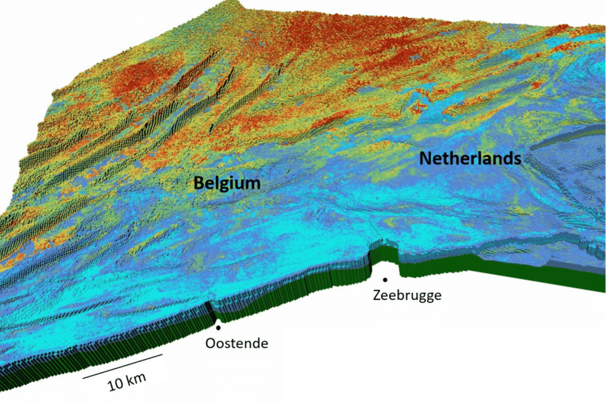
A state-of-the-art 3D aggregate resource model of the Quaternary was therefore built (TILES project, Van Lancker et al., 2019) that resembles very much the types of models constructed by geomodellers in their attempts to better understand sand distribution in oil and gas fields. The model built for the Belgian offshore is much larger though (+/- 7400 km2) and therefore requires a lot of computing power.
Populating the grid cells or voxels with lithological information works in a similar way as is standard practice in the oil industry, with upscaling of borehole data and constraining by seismic data. The image at the top of this article is one of the outputs of the model. It visualises the aggregate quality in terms of the probability that a voxel contains medium sand. Areas farthest offshore have the highest certainty that this important resource is present (yellow to red areas).
However, as outlined above, the required space to extract sand meets competition with the need to build offshore wind farms, preserve natural habitats and safeguard important fishing grounds to name a few.
So, even though the area isn’t crowded with drilling rigs or platforms as other parts of the North Sea sometimes are, the Belgian offshore is far from a quiet place and requires careful planning in order to meet the countries’ future demands.
HENK KOMBRINK
HK would like to thank Prof. Vera van Lancker from the Royal Belgian Institute of Natural Sciences and Ghent University for her time to share her knowledge on the Belgian offshore and her suggestions with regards to literature to consult.